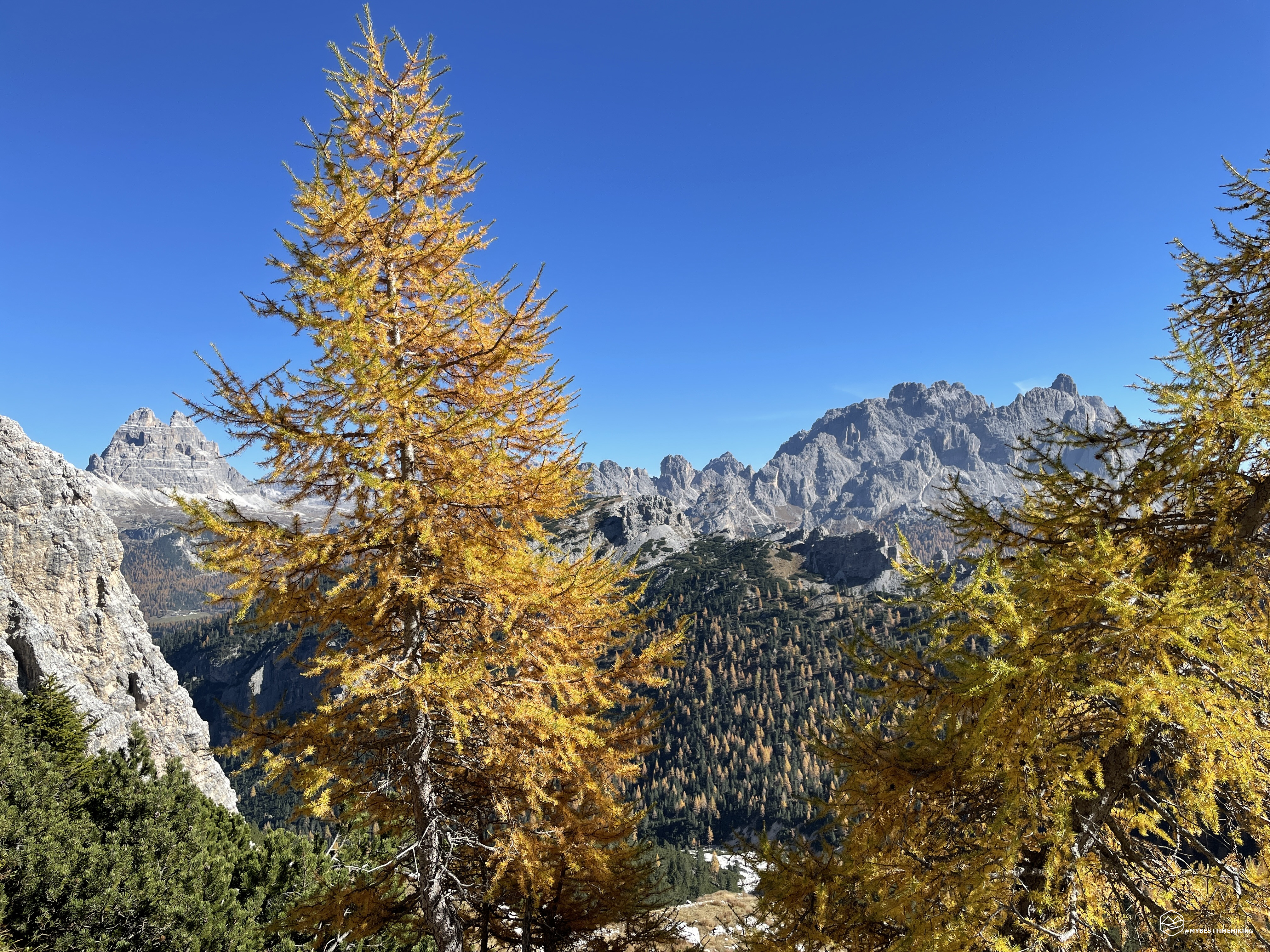


Late autumn, the leaves are tinged with the characteristic bright colors. The season still seems to offer a few days of a summer that does not want to leave us.
9 am, the sun is high in the sky in mid-October, Diego and I have reached the starting point of this new exploration adventure. We are located between Cortina d'Ampezzo and Misurina, shortly after Passo Tre Croci in the direction of the latter. Precisely on the SS 48, at the height of the former roadman's house at an altitude of 1665m, at the Rio de Pòusa Marza, where there is a decent space to leave the car and take the CAI 224 path which starts right from here. br /> A wide concrete mule track accompanies us for the first few meters of altitude. It goes in the NW direction, among colored larches, pines and firs, up to an altitude of 1794mt. An ambiguous deviation shows us both to the right and to the left the way to the Popèna saddle. We choose to take the more "rustic" path keeping to the left and thus leaving the mule track. The path thus becomes more authentic and juggles among low pines, giving us the first views veiled by a light mist.
In short we reach Pòusa Marza, a flat clearing with a small hut where you can contemplate the silence. We veer again to the left and climb among the baranci that have now become higher, even if not yet as dense as we like them! At an altitude of about 1936m, a timid track on the right climbs up decidedly, making us cut a wide bend in the official path and making us gain about 50m in altitude quickly.
Thus we find ourselves on the CAI 222 path, part of the Alta Via number 3, also called "via dei chaosci", which starts from Villabassa and arrives in Longarone, in the Piave valley. We are right under the Corno d’Angolo, a characteristic ski mountaineering destination at the foot of Piz Popèna.
A delightful spring awaits us on a steep stretch created by a recent landslide. We go around this unstable stretch on the right not before enjoying a good sip of this water that gushes from the rocks.
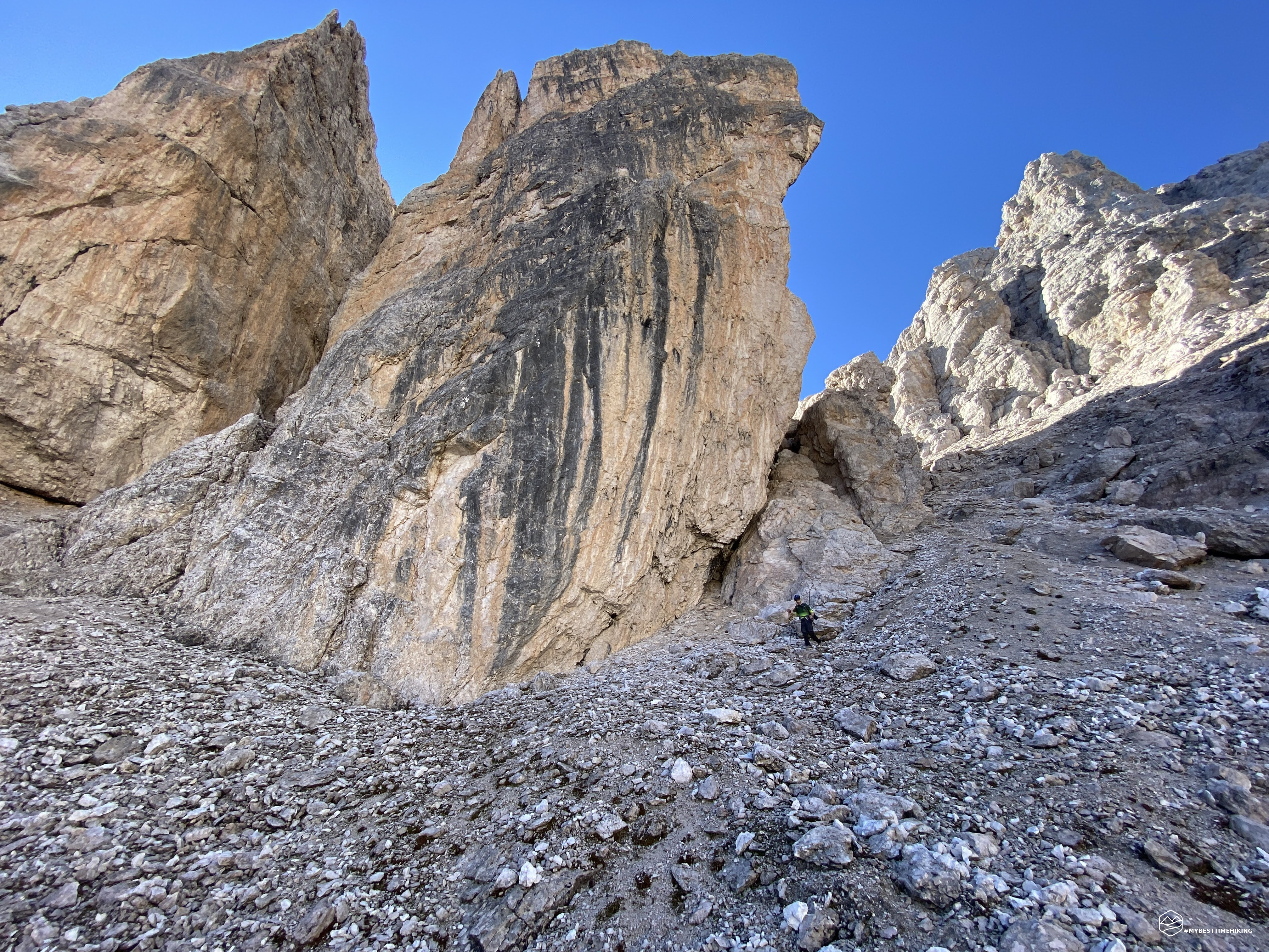
We continue to climb, the slope is never tiring and the route goes again among the pines and some sloping rocks that lead us to a large scree at about 2150mt. The panoramic view opens on the Cadini, the Marmarole and the majestic Sorapiss still obscured by low clouds.
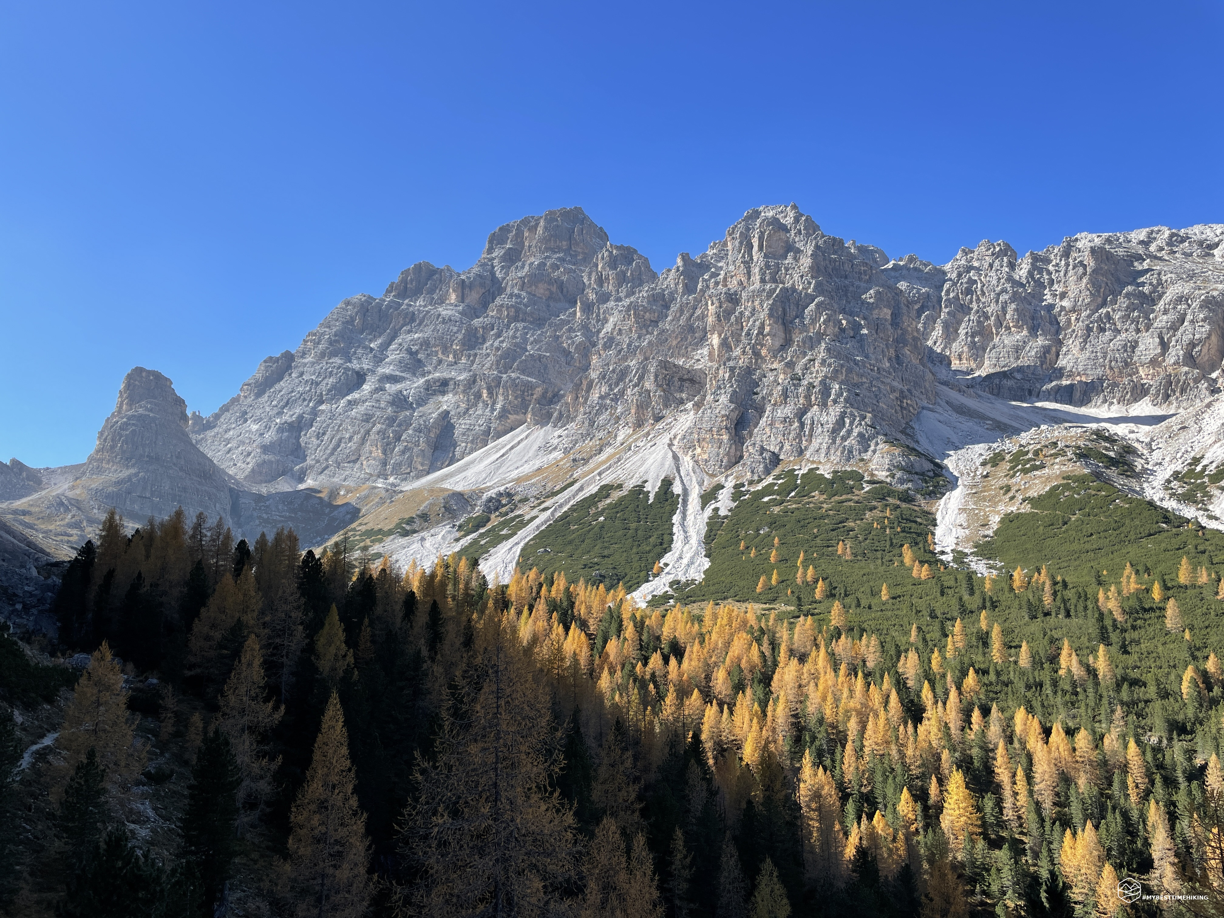
A recent major landslide forces us to make a passage on gravel which is strangely stable and allows us to overcome the deep impluvium formed. Thus we approach the rock, the path becomes narrower. We notice a deviation on the left towards the NE on the CAI 224b track that would take us straight to the Misurina hut. Instead, we choose to stay on 222 and, having decided towards the N, we walk a thin track on the edge of the rock, never dangerous, thus reaching a stretch refurbished in military style: wide wooden walkways, comfortable well-placed steps allow us to climb the last meters towards the Popèna saddle in total safety and agility. The parapets are not present in all points of this section: pay attention to those suffering from vertigo. We thus reach the saddle from which you have a beautiful view of the Cristallo Group. Below us the ruins of the former Popèna refuge. Inaugurated in 1937, destroyed by fire, now only the dilapidated external walls remain. In an enviable position, it embraces the view of the Sorapiss, from Piz Popèna with its bell towers, Punta Michele and the bell towers of Val Popèna Alta.
Here is today's goal: these spiers suspended in the void are the exploratory goal of today's excursion. From the position we are in, the climb we want to undertake seems really daring. We go down to Val Popèna Alta, temporarily leaving the CAI 222 track and choosing "visible" streets to point towards the bell towers.
We go down a dry meadow, we overcome a short stony stretch to start again the climb on grassy crags interspersed with gravel. We go up on this scree disguised as a meadow, decided in the N-NE direction, we head straight towards the Campanile Dibona.
The Campanile Dibona is named after the legendary mountaineer from Cortina d’Ampezzo, Angelo Dibona, who climbed this summit alone in 1913. A titanic undertaking for the time, truly audacious: a bell tower that, to my non-expert climber's eye, seems really impossible to climb without belaying or anchoring.
The closer we get to the scree, which will take us to the saddle, the more we see that the way is possible, the shadows formed by the bell towers had uselessly worried. Now the trace is evident, the points of ascent to the fork seem really feasible without major difficulties.
Date
16-10-2022
Distance
14.65 KM
Hike type
Hike
Ascent
950 mt
- Mountain
Gruppo del Cristallo
- Address
Misurina, Veneto, Italy
- Altitude
2454.00 m
- Refuges
Malga Misurina
- Information
We wedge to the left of a rocky ridge, with the Campanile Dibona showing us the way. We go up until we reach the slender saddle that creates the rocky ridge. We are at an altitude of 2300m from which you can enjoy a view of the entire final part of the Val Popèna Alta. The last tufts of grass are here on the saddle, from now on only rocks await us.
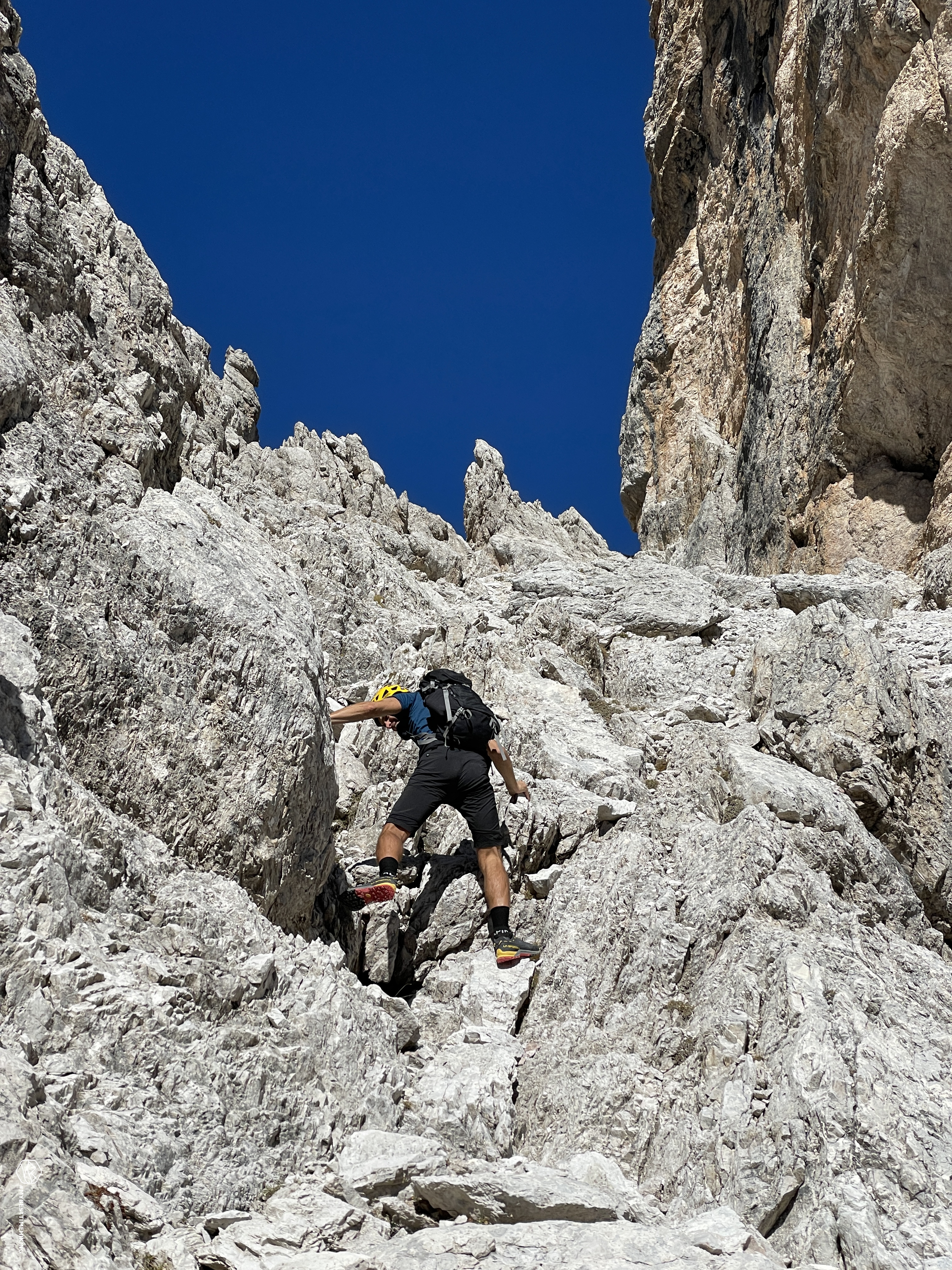
We put the telescopic sticks in the backpack and attach the helmet for safety from possible stone discharges.
Thus we begin the final climb towards the unnamed saddle, the unprecedented saddle of the Campanili di Val Popèna Alta that stand out majestically on our right. We flank them, the characteristic yellow-pink Dolomite rock constantly catches our gaze. Our steps, on the other hand, are made decisive on the gray-white crests of varying sizes. From small stones they turn into compact boulders with small cracks in which we can climb. We thus easily climb some easy rocks, gradually choosing the best direction. The progression is really pleasant in an almost playful climb, never exposed.
The shapes of the bell towers are becoming more and more defined and, looking at them, we can distinguish on the left the fateful Campanile Dibona while, on the right, the bell tower of Popèna Alta. In the center, an unnamed pinnacle is distinguishable only from the angle we are in now during the climb. We are practically behind the famous rock "heart" that can be admired in its original form by climbing to the Cristallino di Misurina and the Michele fork. In these reports you will find photos of this magical rock shape.
Last meters under a hot sun that seems to be at the end of August. The rocks almost turn into gravel, the blue of the sky is getting closer and closer. At noon we reach the saddle!
The view from here allows us to observe the climb that we have just covered overlooking the sweet end in Val Popèna Alta. Other rocky ridges do not allow us a clear view of Piz Popena. The funnel towards the descent from the saddle is so bleak and narrow that it is scary. It seems that from here it is not possible to descend easily. We are looking for a second descent route, then, bypassing a rocky ridge to our left through a comfortable ledge, thin, but with easy grips. We come out in a few steps on a second window of the fork where the digression seems much more feasible. Only the first few meters seem really crumbly and unstable… in fact they are just like that!
We decide to go down this side, in this gorge in the shade with a gravel, not very hard, but highly unstable. We walk these few meters with all the calm and attention possible, moving slowly to the left and gaining an easier inclination and more comfortable gravel.
From here we have a truly spectacular view: on the left the legendary Michele fork, unmistakable, then passing through the normal route to the Cristallino di Misurina. The gaze continues on the fork de le Bance, then descends into Val de le Barache and stops at the sight of the Tre Cime di Lavaredo that stand out, central, between the Cristallino and the wall of the Campanile Dibona that we can almost touch with our hands. > We first move to the left, where we find a faint trace (perhaps of chamois), which brings us back to the right. We go down on sometimes slippery ground. It is mandatory to have a sure and firm step.
We fold back to the left to avoid very evident rocky leaps and thus we wedge between boulders and blocks where we descend with ease. You don't even need to unclimb. You need to have a sense of direction and a critical eye to choose the easiest way. After this challenging stretch, we find ourselves on the gravel gully. A common gully that points straight to the Val de le Barache.
At first a bit hard, then it turns out to be a "skiing" scree. I turn around and no longer see Diego, who has already left for a liberating race on the inviting gravel. I follow closely, having fun like crazy in sinking my boots and creating that unmistakable sound of a fast descent of the gully. Every now and then I turn to the Campanile Dibona to scrutinize the road I have just traveled: a nice exploration!
We arrive in Val de le Barache and, at an altitude of 2170m, we rejoin the CAI 222a path, normal route to the Cristalino di Misurina, where we stop for a short restorative break.
We then go down the path until we reach Val Popèna Alta. Here we head to the opposite side in the E direction until we reach the CAI 224 path (variant of Alta Via number 3).
The landscape changes completely: from the recently left scree, from the majestic rocks of the Cristallo Group, the environment becomes sweeter and more pleasant with the presence of yellow-orange larch trees. We have to go up again to reach the highest part of the Costa de Popèna.
Walking inside the multicolored larch forest does not make the climb difficult, you proceed very quickly thanks also to the not excessive slope.
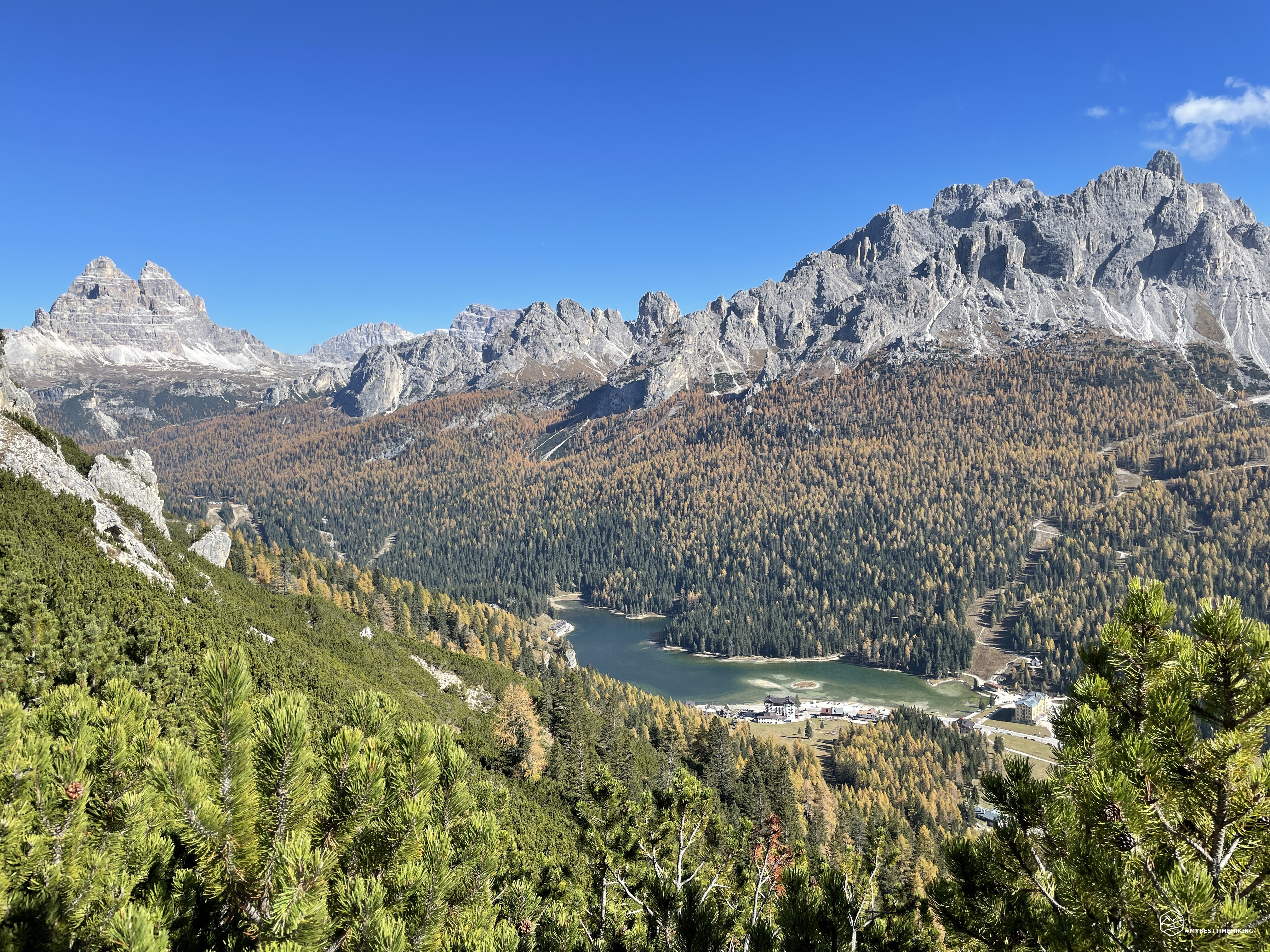
In short we reach the top of the Costa de Popèna from where we begin to see Lake Misurina and the magnificent Cadini.
The path now descends gently between high pines. At the first bend on the left, looking up, you have the most beautiful view you could wish for: the lake, emerald in color, embraced by the sloping Cadini to your right. The warm yellow larch trees dot the wood of the Col de Varda; in the background, the Tre Cime di Lavaredo stand alone, closing an autumnal picture that leaves you speechless!
We enter an increasingly dense forest, until we reach a large clearing where a large hut with an adjoining stable emerges: the Misurina hut! At an altitude of 1795m our excursion ends, we sit comfortably at a table in the malga: sun in the face and warm warmth anticipate a succulent lunch based on local cold cuts and cheeses. A round of homemade grappa is a must while contemplating the feats just experienced.
Malga di Misurina is a 10-minute walk from the main road and can be easily reached by car: for people who are minimally prepared, I recommend that you reach it on foot and then go back along the path just described and enjoy the splendid view.
This concludes a splendid exploratory adventure, free from technical difficulties, exceptional from a landscape and historical point of view. An excursion suitable for expert hikers only for the ascent, and the first landslide downhill stretch, of the Campanile Dibona fork, the rest of the exploration juggles ample tourist trails with CAI trail markers within everyone's reach.
For more information, details and photos of the adventure do not forget to read the Diego's wonderful report on his blog WindChili!
DifficultyExpert hikers - are generally signposted itineraries but with some difficulties: the terrain can consist of slippery slopes of grass, mixed rocks and grass, stony ground, slight snowy slopes or even single easy-to-climb rocky passages (use of hands in some places) . Although they are routes that do not require particular equipment, equipped sections can be presented even if they are not demanding. They require a good knowledge of the alpine environment, a safe step and the absence of vertigo. Physical preparation must be adequate for a fairly continuous day of walking. |