
I searched for a title that represents with a few words the immensity of today's adventure but I don't think we have succeeded. Even the subtitle does not help me because there are too many strategic points, too many stages to mention by importance! The correct title would be: "Summer crossing from Val Popéna, Via Forcella Michele, reconnaissance of the popéna and crystal glacier, up to Val Fonda"!
A bold path, most probably unpublished in the summer season, suitable for expert mountaineers with great spirit spirit. Thanks to my friend Diego I have the chance to experience this magnificent experience and to share it to allow some other passionate to be able to undertake it or at least dream. Given the peculiarity of the street and the limited information we have managed to find in some points of the journey, will be our Also Giacomo Zardini, Guide to Cortina d'Ampezzo, which will help us overcome any unexpected. For me it is the first adventure with an alpine guide: another emotion that is added to my baggage of Dolomite experiences.
Let's start! Alarm clock at 4, a nice charge for breakfast and Via Cortina d'Ampezzo where we appointment with Giacomo at the bus station. The weather should be cleavage from the forecasts we have consulted. The sky, however, is gray with compact clouds. At the height of Borca di Cadore begin to go down the first drops of rain and we begin to fear the worst. Arrived in Cortina the rain is a bit more insistent even though it remains very light. We come in advance with respect to what is agreed, so we opt for a walk to the center of Cortina even if in the rain. Slowly the rain begins to slow down, at 8 punctual as a Swiss watch arrives funambic at the mythical Giacomo. Some beats and we follow him to reach the final destination. We reach Ponte de la Marogna after passing Passo Cimabanche and Carbonin. We leave Giacomo's car here and head to the stage of departure to Ponte Val Popéna Alta, a few miles later on the same street. The weather improves, the rain stopped and the clouds leave room for some cropping of blue sky.
We verify the equipment from mountaineering, which today increases the weight of our backpacks, synchronize the watches and leave! The first thing we notice at the Imbocco de Path Cai 222 is a nice plaque with the word "closed path". We look at each other and confirm that you have done well to rely on an alpine guide! Most likely the closure is given by the landslides that have canceled part of the traced path. We hold the orographic left of the Rio Popéna and go back with a sweet slope between the rocks and the limit of the forest. The slope is pleasant and we have the chance to chat with Giacomo on its history of alpine driving, its experiences, the life of him! Having such a prepared person and so in hand makes the mountain even more fully fully. Every now and then there are also pearls on the surrounding flora. Up to the fee of 1900mt the path remains almost constant, until the vegetation and reunion with the Greto del Rio Popéna is released. Here we walk on the scree created by the Rio, after a while we go back to the orographic left and leave it behind. We reach a beautiful glade in bloom with a magnificent view of the Piz PiZ. We soon realize that the path is gone and that we are following the winter ski mountaineering trace. We had to stay more determined to the right to keep us in line with the path. Thus, to resume the path we make a very short scorpacity of pines Mughi.
Founded the path Here is a deviation that allows us to cut and return surrounded by the Baranci, though on a beautiful spacious street. We continue to rise from here the climb becomes more decisive. We arrive at a barrier made with stacked branches and an arrow (congratulations to those who made it) created with very white stones and willing to form the indication of the right direction to be undertaken. We are at almost 2000mt of altitude, looking to our right we can notice the three peaks of Lavaredo who stand out in the distance, the Mount Piana in the foreground. Continuing you can observe the Val Popéna just traveled throughout its beauty.
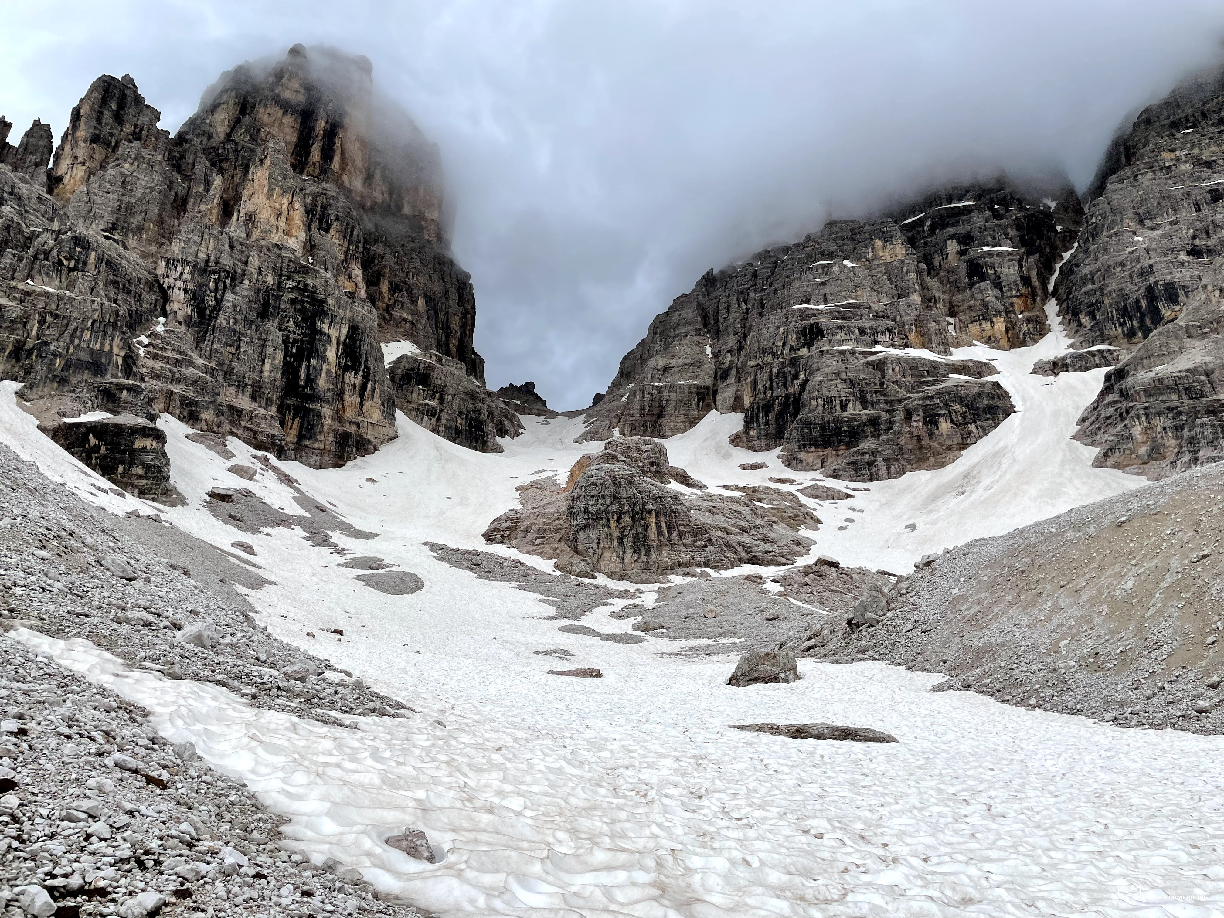
Last mughi and nature changes, it makes it less lush and begins to be more and more the presence of stones and gravel: we started Val de Le Barache and the CAI 222A path. This valley, during the First World War was disseminated with barracks, precisely, hospitalizations and cableway that connected the other stations on the crystalline. The sloping and imposing rock that stands out to our right is just him: the crystalline of a measure. It is easy to notice a deep slit on the rock, own central than our position. It's right there that ends the crystalline and starts the popéna group. And it is right at that point that there will be the first stage of today: fork Michele.
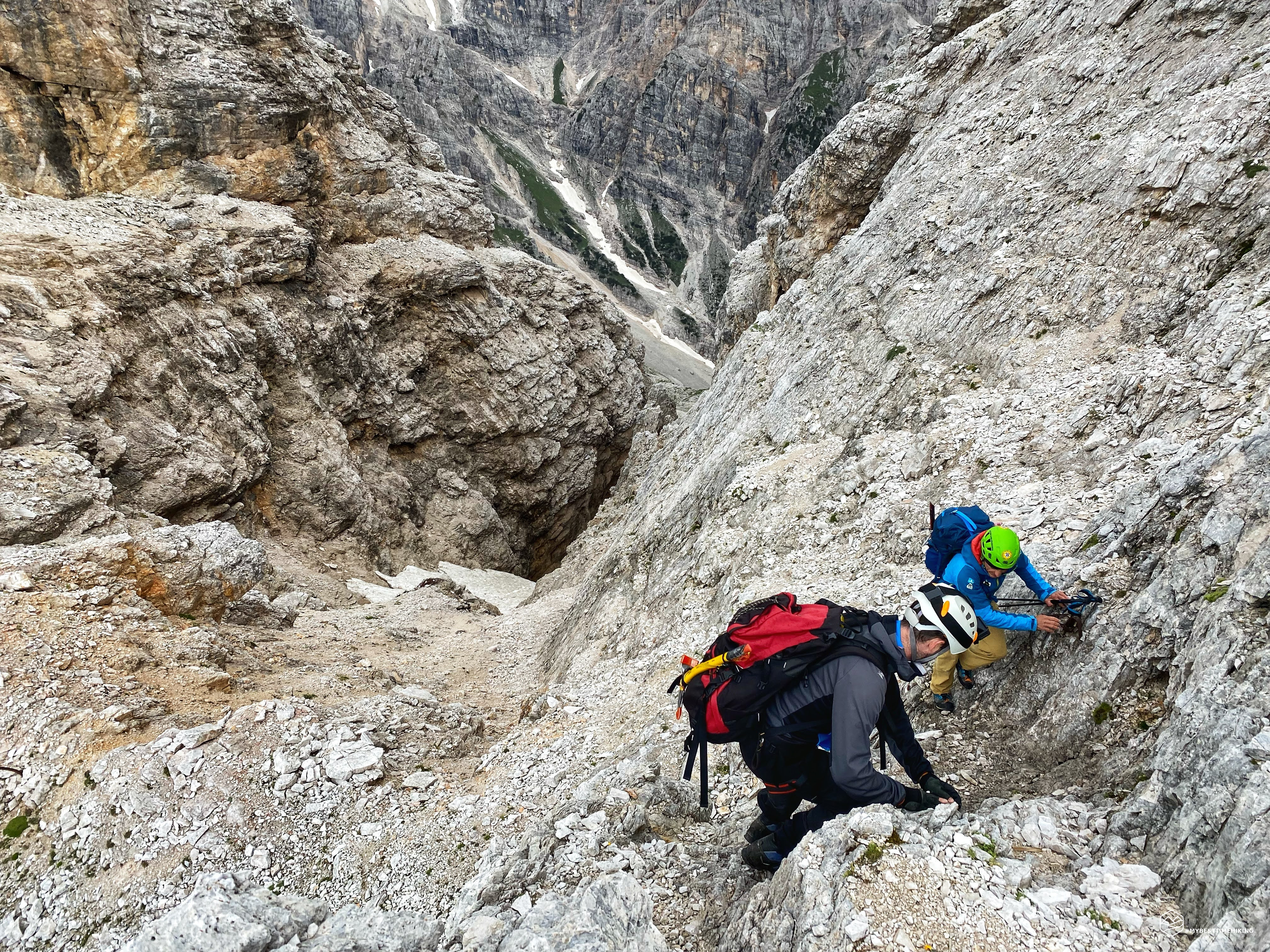
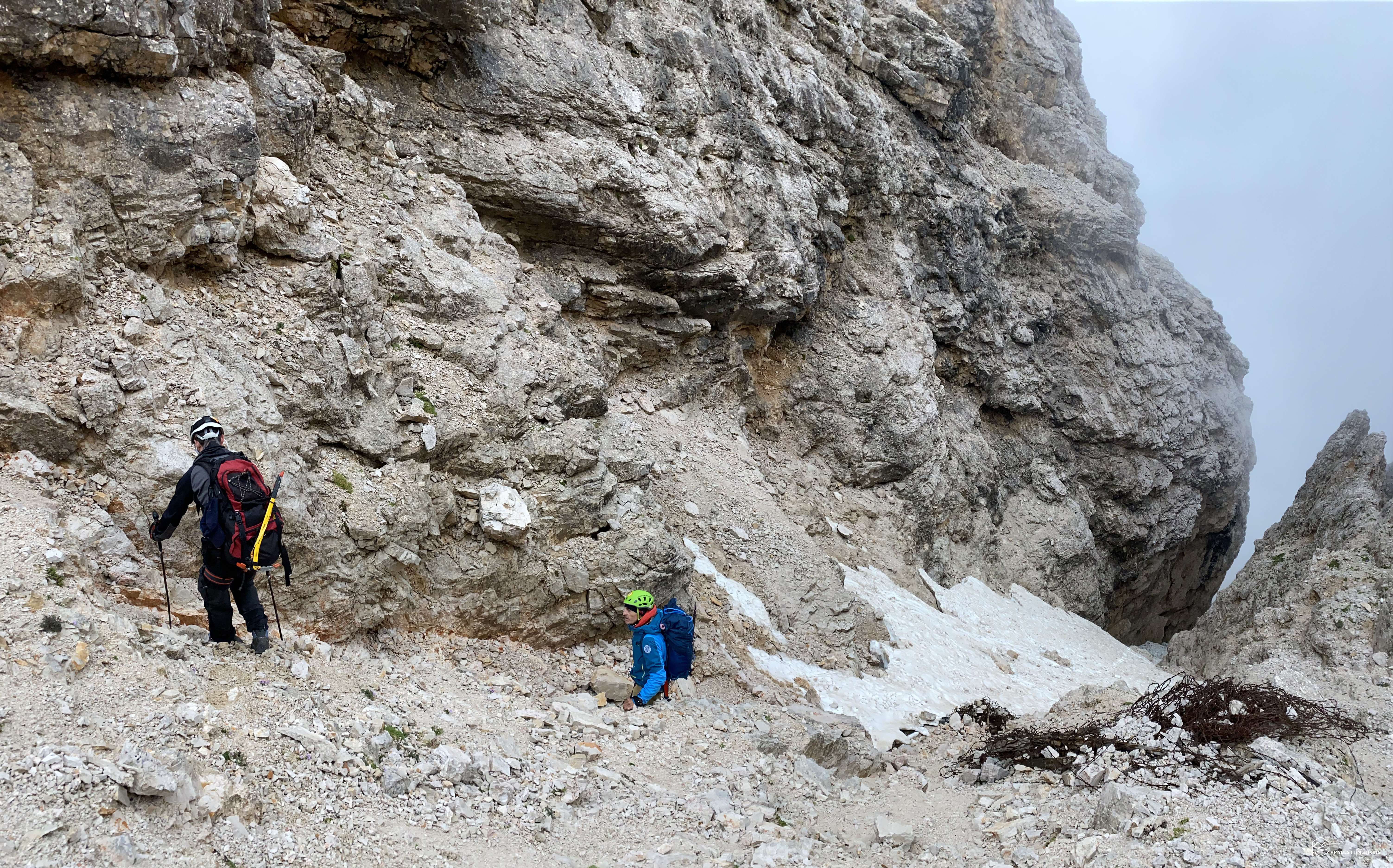
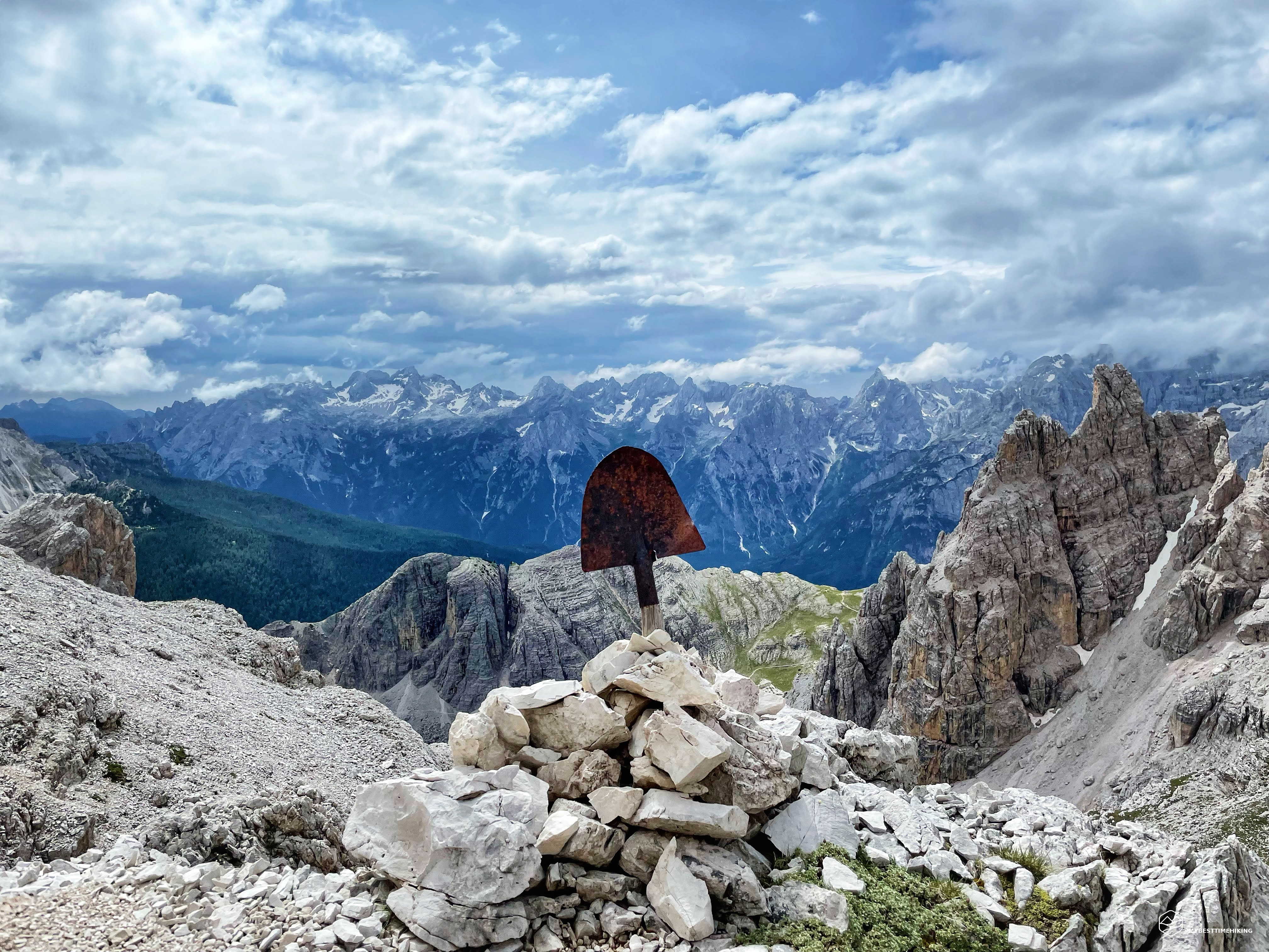
The path continues and advances conveniently to Zig Zag to make quota. When our gaze goes to the left of Val de Le Barache we can see the bell towers of the popéna with a beautiful heart-shaped rock poised on the valley. At about 2300mt begins a beautiful brand new via ferrata that allows you to get from the rust that addresses the fork of Le Bance. The equipped piece allows you to go safely on a well-weld rock. There are no pieces exposed and the climb is rapid and not very tiring. At the end of the ferrata you pass a wooden bridge, recently sampled even with concrete reinforcement, and where we find a huge metallic ring set in the rock. Surely it was used during the war for mortar and mule anchorage. The path continues on quite easy and ever exposed rummies. In some places, small rock ravines develop in which it is necessary to get to advance. Detail to report is the presence of a badile dating back to the war period, which overlooks the Val de Le Barache and allows you to have a spectacular view of the Sorapiss group. We reach the highest share of the day 2632mt. We stop for a short break and observe: we are on an old military structure with the remains of barbed wire, trunks and nails everywhere. We have a spectacular view of the crystal massif from which you can see the Cross and Lorenzi Refuge for several years (sigh ...). Here we cross the only forms of human life of the day that are heading to the top of the crystalline of a measure. They continue on the right and follow the path.
Date
18-07-2021
Distance
18.81 KM
Hike type
Hike
Ascent
1101 mt
- Mountain
Cristallino di Misurina
- Address
Cortina d’Ampezzo, Veneto, Italy
- Altitude
2632.00 m
- Refuges
- Information
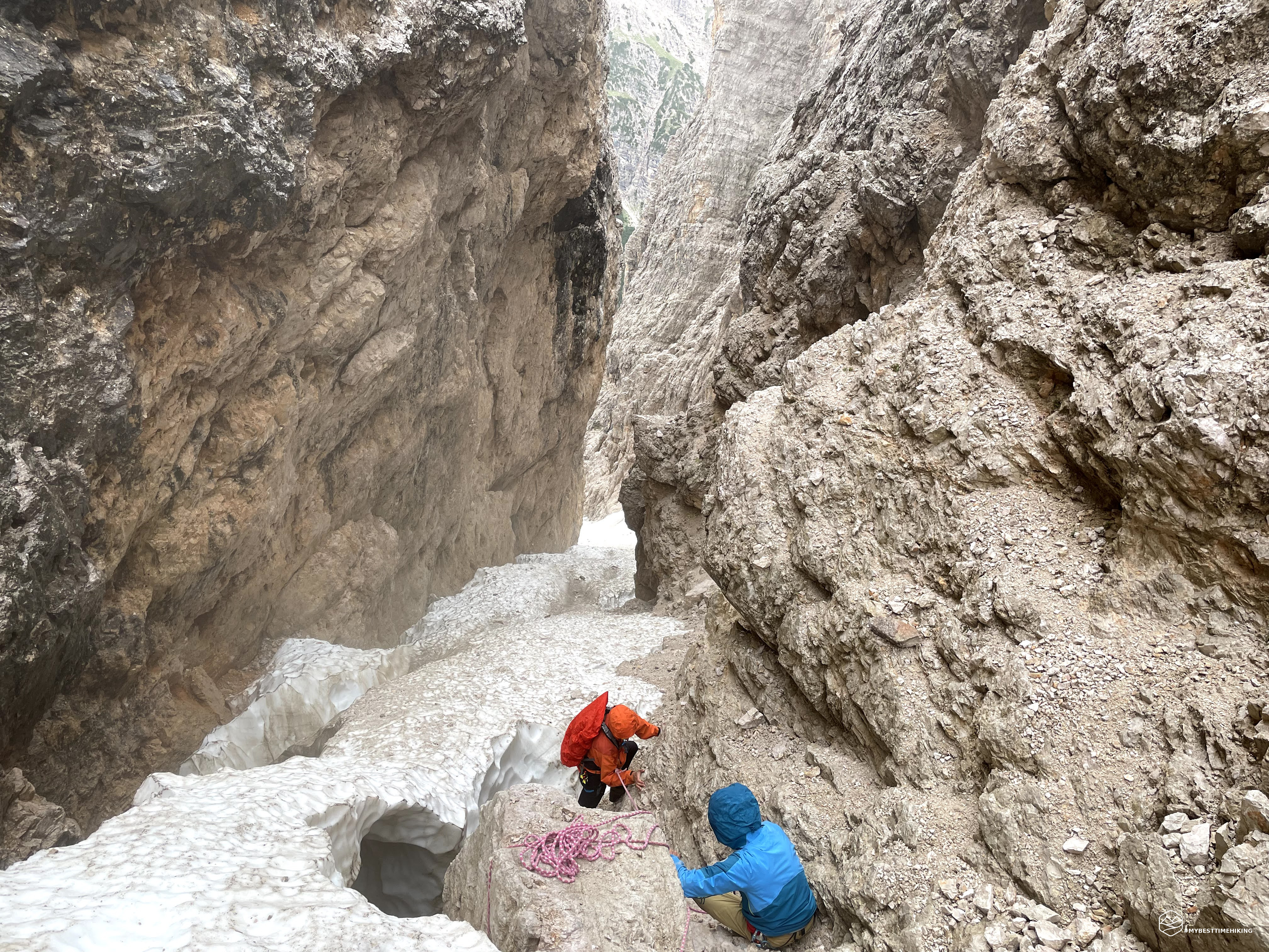
We, instead, log left, go down slightly, and take a timid trace that takes us to a spectacular window that from towards the crystal circus. We can already see the path we will return. Still a few steps on the left and here it is there: the fork Michele. With its very thin blade shape, narrow in width, and certainly inviolated for months, it is waiting for us with its moistling call. From the summit of the ridge, looking towards the path just route, you can notice a well-decked cocuzzolo. Instead, turning a look under, towards the north-west it is possible to observe the lupo's mouth that is waiting for us: a descent between unsafe boulders, Sfasciumes and a snow tongue that we see mentioned but that we can't understand until where it will last. Here begins a few drops of rain, or rather, a cloud of moisture charge comes from the bottom of the throat, as a prolonged lien of a big bear waiting in his den. The beginning is challenging but allows to descend easily according to the unstable stones that are found. We continue thus for about ten meters and then reach the snow tongue we had noticed from the apex of the fork. Here the path is definitely more comfortable, even if the snow is quite soft and slippery. We must be determined in the steps to avoid losing support. It seems too simple and, in fact, about half of the path the snow tongue becomes thinner, dissolved at the edges creating a dangerous suspension bridge that we cannot go. We need to choose the right side of rock and overcome it and then find the compact snow lower. Unfortunately there is a nice jump that awaits us. It was created by the erosion of the water and, with the dissolution of the snow towards the center of the throat, a group of rocks was discovered that does not allow us to easily advance. The only solution is to an anchor to the larger boulder and deserve safely. Giacomo prepares the safe, begins Diego who, clinging to the vertical rock, performs a crosswood off the way from debris and facilitating my descent. It is the first time I carry out a passage anchored to a safe rope. The feeling is strange, I feel pretty sure, but not at ease. They exceed rock leap and release the carabiner. It reaches Giacomo in a double rope and we conclude the difficult obstacle. From here he resumes snow, with beautiful "trays" that allow you to sink the boots with more safety than before. We achieve without other difficulties the intersection with the crystal clear fork that descends to our right. We must decisive to the left keeping us very close to the walls of the popéna and we head towards the glacier. We find a beautiful passage that turns out to be very convenient for the presence of abundant smudge that allows you to sink into a safe and fast descent. In short we reach the base of the popéna glacier, or rather, what was once the apex of the popéna glacier. We reach 2370MT altitude in the presence of the "Grande Mass" which was to be the identification of the last report of the glacier's front in the early 1900s (for more details, I refer you to the fantastic article by Diego, link below). The snow is very present, but you see that the glacier is suffering not a little ...
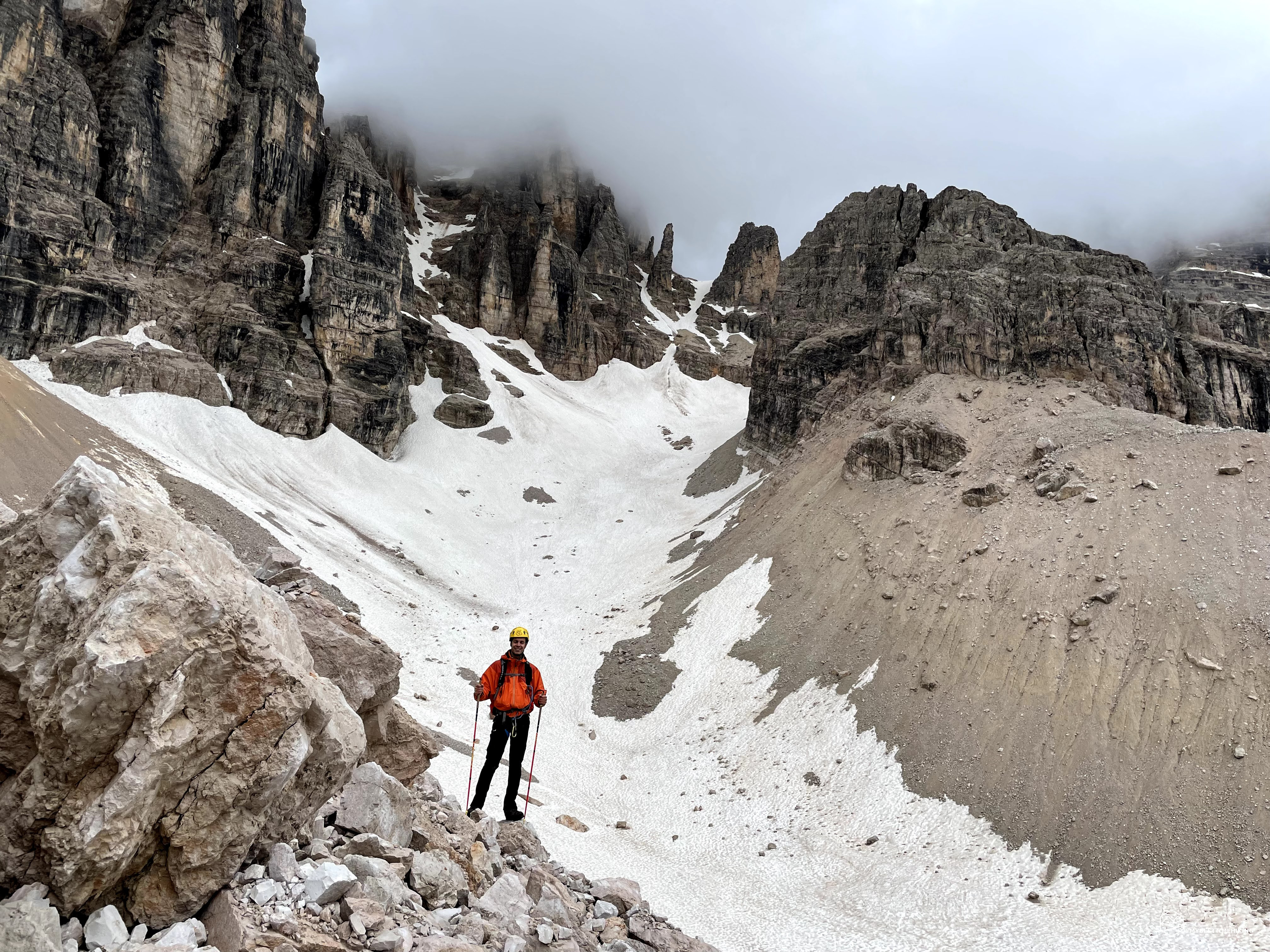
We continue towards the crystal glacier to see how it varied compared to last year (see crystal glacier). Giacomo Devia to the right and wait for us while I and Diego resume a bit of a fee to overcome the ridge that separates us from the second glacier. The climb is felt, but in short we reach a position to be able to make a comparison with the state of last year: thanks to the copious falling snow during last winter we remain pleasantly affected. The crystal glacier has a greater amount of snow mantle that hopefully is helping to slow down the withdrawal of the glacial front! We see in the background the crystal fork that looks at us, also beautiful candida and immaculate, while the peaks of the popéna to the left and the crystal on the right are covered by the clouds that persist. We go down to the morainic crystal circus scree and find James for the last round piece of the day.
Now we have the last difficult descent given by the throat with the presence of the famous waterfall. Last year we traveled uphill, today we do not know how the situation can be. We remind you that there was an old via ferrata, even late 800 which, holding the orographic left of the stream, should favor the descent. Also Giacomo intends to take this choice and find a path marked with red traces. In a few steps the path immediately turns into a rock jump where, insured by Giacomo, we can overcome the in very brief the first leap. The fragore of the waterfall not far is stronger. The way to go Now turns into a very narrow and deep throat, crossed by a lot of moisture and with an unstable structure distinguishable already from the distance. Giacomo ensures us one of the "more stable" nails of the old via ferrata. Start Diego who falls throughout the length of the rope we have available. I don't see it because I'm back to the view of the throat, but I feel all the difficulty! It's up to me is Giacomo constantly repeats the phrase "dropped weight! ... throw the basin back .... Put your legs perpendicular to the rock and throw yourself out! " Here you can see all my inexperience regarding the rope with the rope and my fears related to "but the rope will hold?!". It almost wanted almost all the descent in the throat, but in the end I managed to understand what Giacomo intends and actually, as is the conformation of the rock, it is much easier to fall in weight instead of attempting to cling to rocky spikes that yes They just escape to watch them!
Touch The scree: I arrived! At this moment I feel that this last experience has also gone to my personal luggage. Restraint rest with respect to the throat to allow the descent to Giacomo and to avoid any discharges of stones. Thanks to Diego you can also see the decrease made by Giacomo in double rope and free for a while, where you can observe all the Leggiaria of him. We are on the same junction that we have traveled last year: from here, we had chosen the waterfall for the climb completely ignoring the newly crossed invitation. To tell the truth, covering the subtle and disconnected gorge from which we just went down if I had to choose, I would always choose the waterfall! We are at about 2000mt and we go down to rock mixed grasses decided towards the Val Fonda Tiefental. On the right the rock leap stands out from the rest of Panorama thanks to the waterfall that falls for about ten meters in a spectacular dip. Once on the gravel fund of the Val Fonda begins the long descent that winds between gravels and the presence of rivoli that form the Rio from the name to the valley. Towards the end we take a trace that goes up to the right on a scree and then in the middle of the mills to avoid the bottom that becomes more disseted and crossed by more and more water. We relieve at the end of the valley in the process of the majestic mass that acts as a "door" of the Val Fonda. From here, in a short time we reach the car we left in the morning at the Ponte de la Marogna.
Thus ends this epic (yes, for some traits it was epic) exploratory excursion, of recognition of two unknown dolomite glaciers to many and almost unpublished for the summer season. Thanks to the indispensable help of the legendary Giacomo Zardini, but above all thanks to Diego who wanted me to accompany him to this unforgettable experience!
Don't forget to go and see its detailed report, with historical notes, anecdotes and scientific in-depths on the way traveled: Fork crossing Michele and exploration of the popéna glacier (... with final reconnaissance of the crystal glacier)
DifficultyExpert Hikers with Equipment - The equipped routes (or via ferrata) are indicated, they require the use of self-insurance devices. |