New exploratory adventure in the Giau Pass area. This excursion has different facets that range from history, to archaeology to the Ampezzo legends. The mountain and the excursion itself almost take a back seat today. Together with me, my partner Diego, the creator of this circular tour with spectacular twists.
As I was saying, we start from the Giau Pass, a super touristy place, crossed by thousands of people every year. We will take hidden paths, a few steps from the "merenderos", to rediscover uncontaminated areas, unknown to most people, but with a great historical-cultural heritage.
We park the car before reaching the pass, on the Ampezzo side, just past the Muraglia di Giau. This is precisely one of the rediscoveries of the day. A two-kilometer-long dry stone wall that cuts the Giau Valley longitudinally from East to West. A work created in 1753 by the inhabitants of San Vito di Cadore to delimit their grazing area due to disputes that had been going on since 1300. But let's see how this wall is described in history books, the interesting ones, such as "The discovery of the Dolomites" from 1862 by Paul Grohmann: […] From Pocol the path enters the woods, staying below the slopes of Formin until it reaches the border of the municipality of Ampezzo, which cuts the Giau valley with a real wall, the upper part of which, which is all a grassy expanse, thus belongs to the province of Belluno. […] The wall, which is about 2 km long and was 2 meters high, still exists, although in places it is decapitated or ruined, and covered with debris and weeds. This wall, which closed the head of the Giau valley where the pastures belonging to San Vito since time immemorial stretched out, was built, following a mutual agreement, by the people of San Vito in 1752 (Grohmann's error) to definitively delimit the borders with those of Ampezzo. This also closed a long period of disputes and disagreements that those contested borders had originated between the two communities.
In the “Guide to the Ampezzo Valley and its surroundings” of 1905, however: Mount Giòu is on the territory of the Kingdom of Italy and is a disputed wooded plateau with pastures, whose disputes between the inhabitants of Ampezzo and S. Vito were only resolved in 1753; and as a border line a long wall (Marogna) was built in the same year from one cliff to the other. You can get there by way of Pocol and Pezziè de Parù.
For those who want to further explore the issue of borders, disputes and how we got to the current border, you can read this exciting thesis by Annamaria Pozzan. On page 115 you can start to find specific information about Marogna del Giau.
As soon as we leave the edge of the road there is the first stone with a beautiful engraving indicating the year 1753, near a modern road sign of the border between the municipalities of San Vito di Cadore and Cortina d’Ampezzo. The adventure begins here, following the trail of the wall. Today reduced to less than a meter in height, covered in moss and brushwood. In some places it disappears completely, making us continue our trail imagining only the straight line of the wall. We arrive on the bed of the Rio Pra d’Adamo and begin to climb decisively in the direction of the high walls that determine the Lastoni di Formin. The climb is steep, hard, between uncultivated grass and small shrubs. The wall reappears, and in some places, it is definitely in good condition. A modern electrified cable delimits the grazing area always adjacent to the wall.
We enter more and more into the thick vegetation and soon we have to undertake the usual fight against the baranci. With a careful eye it is easy to identify a timid trail that allows us to easily overcome the thickest points. In this area we leave the wall on the right, looking for the easiest path among the mountain pines. We soon emerge on a grassy shoulder with an adjacent gravelly drainage basin. We approach it keeping to the grassy part as much as possible and returning towards the fir trees. Here we find a large rock cut from top to bottom with a thin crack but sufficient to pass through it. The presence of earth and small rocky protrusions allow us to overcome the rocky block. We are very close to the rock face of the Lastoni di Formin.
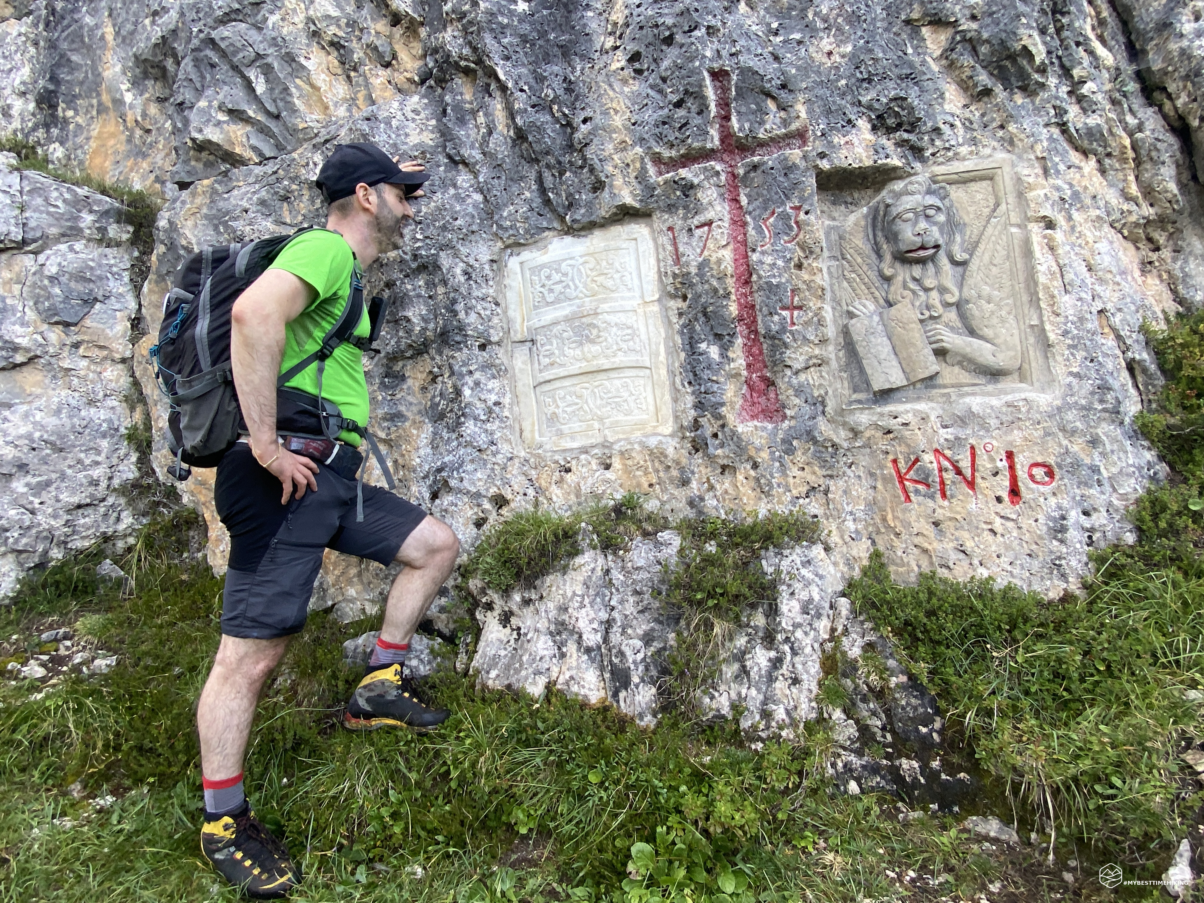
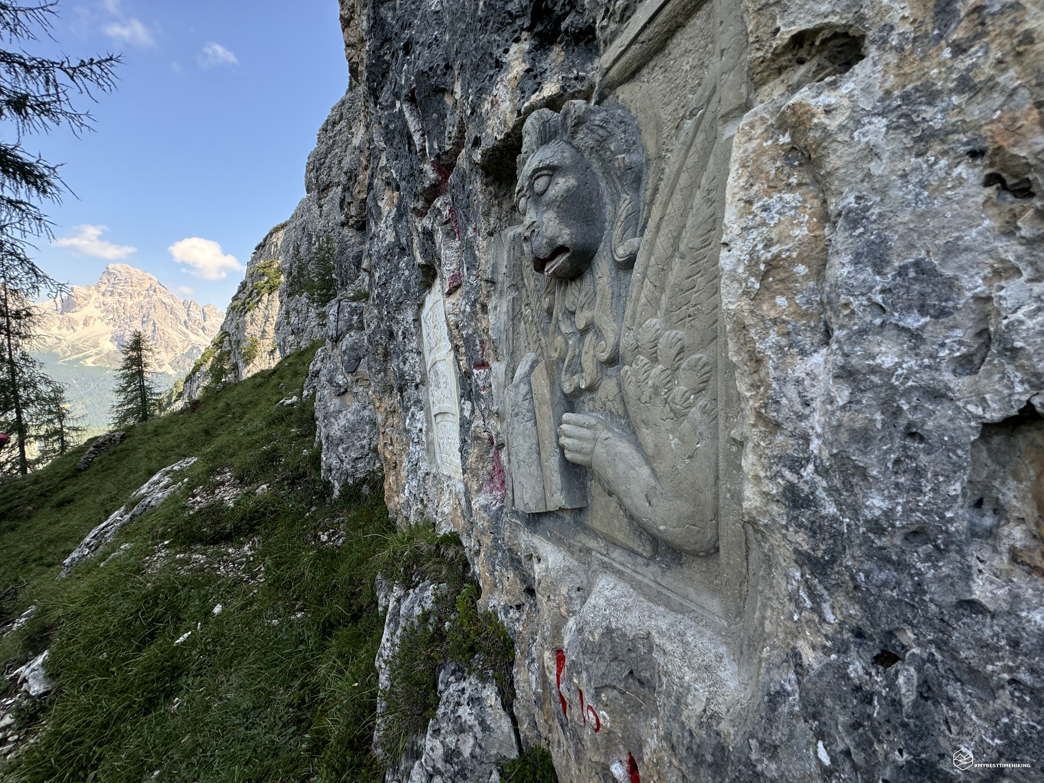
We stop to locate the straight line of the wall and find the point of junction with the wall, we move slightly towards the South and, there it is! The end (or the beginning, depending on the point of view) of the Marogna de Jou, the Wall of Giau!! A border coat of arms engraved, or rather, "affixed", set into the rock to indicate the area of Ampezzo and Belluno. On the Ampezzo side here is a white stone stele, almost marble with stylised designs, on the right instead the representation of the Lion of San Marco indicating the Serenissima of Venice. In the centre a majestic cross painted in red with the indication of the year 1753. It is an immense emotion. Here in 1753 simple shepherds, workers, an entire village united to protect their clearing, the mountain pasture that guaranteed subsistence to the entire population. With only willpower, sweat and perseverance in 90 days they created this wall from one side of the valley to the other. From where we are it is almost difficult to see the Beco de ra Marogna that marks the other end. It is incredible how the engravings are still so well preserved, like the stone steles. You can also see that the lion's eyes and tongue were painted red in the past. Also, if you look even more carefully, you can see signatures of passers-by who also wrote the year of engraving: 1858, 1866, 1908… An open book on the past for over 270 years!
Date
25-08-2024
Distance
4.86 KM
Hike type
Hike
Ascent
512 mt
- Mountain
Lastoni di Formin
- Address
Passo Giau, Veneto, Italy
- Altitude
2290.00 m
- Refuges
Malga Giau
- Information
We leave this magnificent place to head towards the unnamed and unmarked fork on the topographic maps. We skirt the rocky walls of the Lastoni (or Lastoi) and find a very clear track that directs us right towards the fork. We also pass the landslide basin which at this height is decidedly simple and agile to pass. In short we are at the fork: a steep and truly accentuated climb but facilitated by the presence of grassy ledges. With agile zig-zags between the firm rocks and the comfortable grass we manage to gain the missing height difference. We name the destination as "Forcella della Marogna" in honor of the wall which is actually very close.
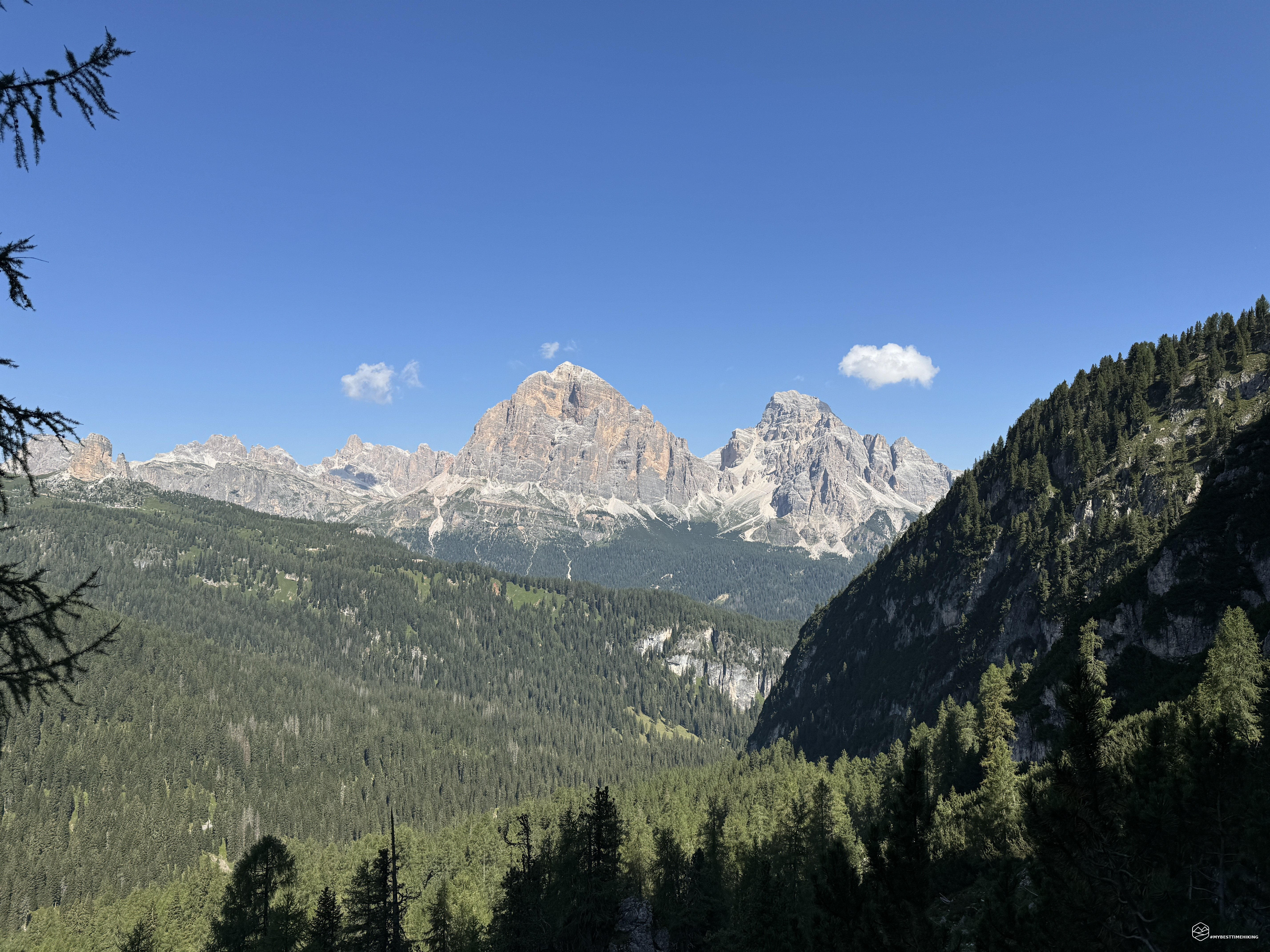
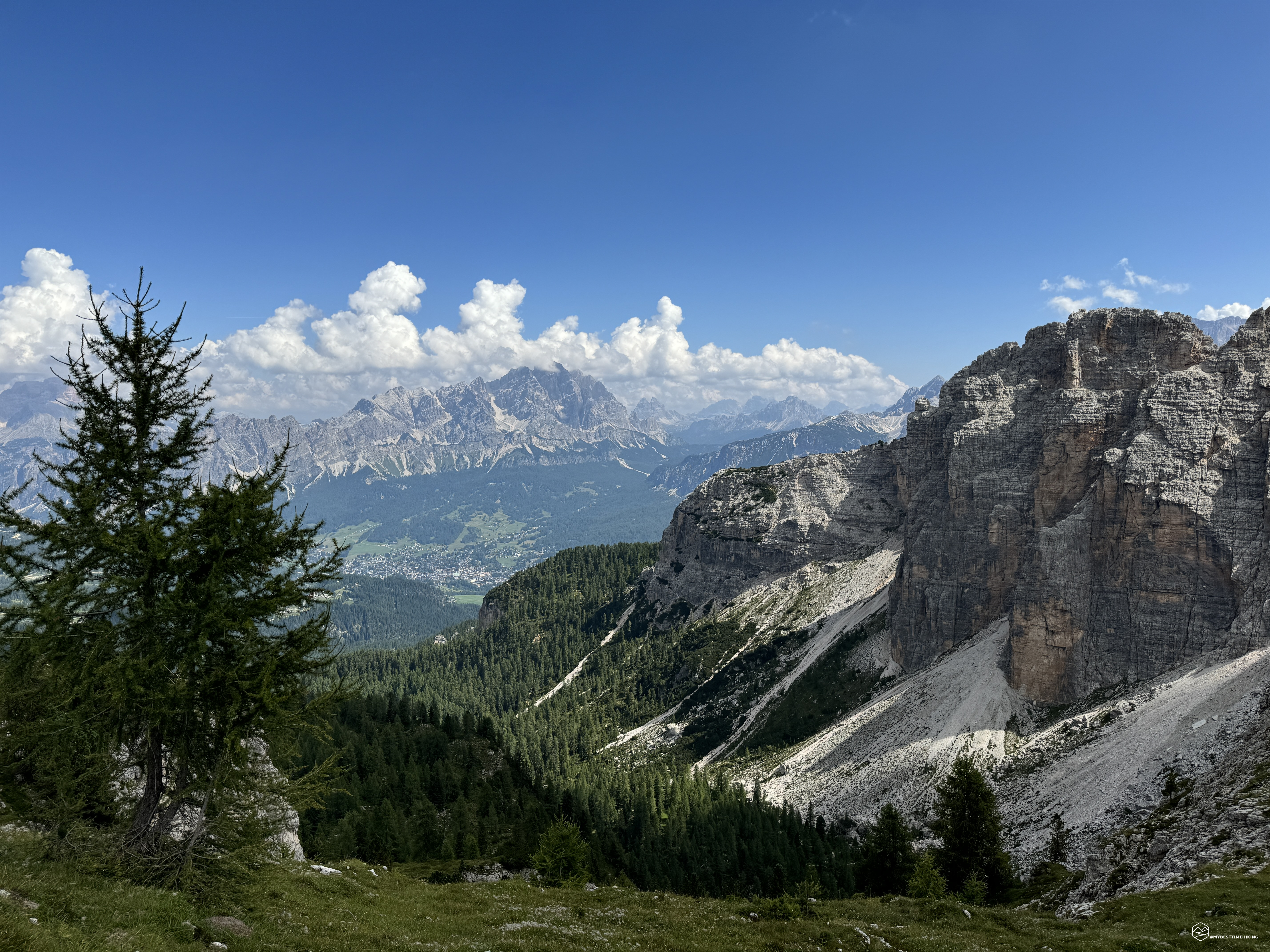
The view from the fork is exceptional: the Tofana di Rozes stands out with its unmistakable pink color and is emphasized even more by the clear blue sky of today. Looking east we see the imposing Croda da Lago. In front of us the Lastoni di Formin plateau, more precisely we are in the area called Pènes: a grassy clearing with some trees around it.
We climb the last few dozen meters to be right on the top of the plateau and we are dazzled by the beauty that we have all around us: from the Tofane to the Cortina d'Ampezzo plain protected by the Pomagagnon and the Cristallo group, we move on to the Croda da Lago group, so close that we can almost touch it with its sheer walls with the Dolomite color par excellence. On the opposite side the Ra Gusela that stands out on the Giau pass, the Nuvolau that emerges behind, the Averau, the unmistakable Cinque Torri and the Lagazuoi. The tour ends on the extreme tip of the Lastoi de Formin that continues its jagged ridge up to us.
Interesting is a note by Paul Grohmann in the 1862 book in which he reports: […] Is Formin perhaps an abbreviation of Formarin? In that case, as Steub states, it would be equivalent to Val de Marina. Marina would derive from «mara», Muhr, (mudslide, debris) […]
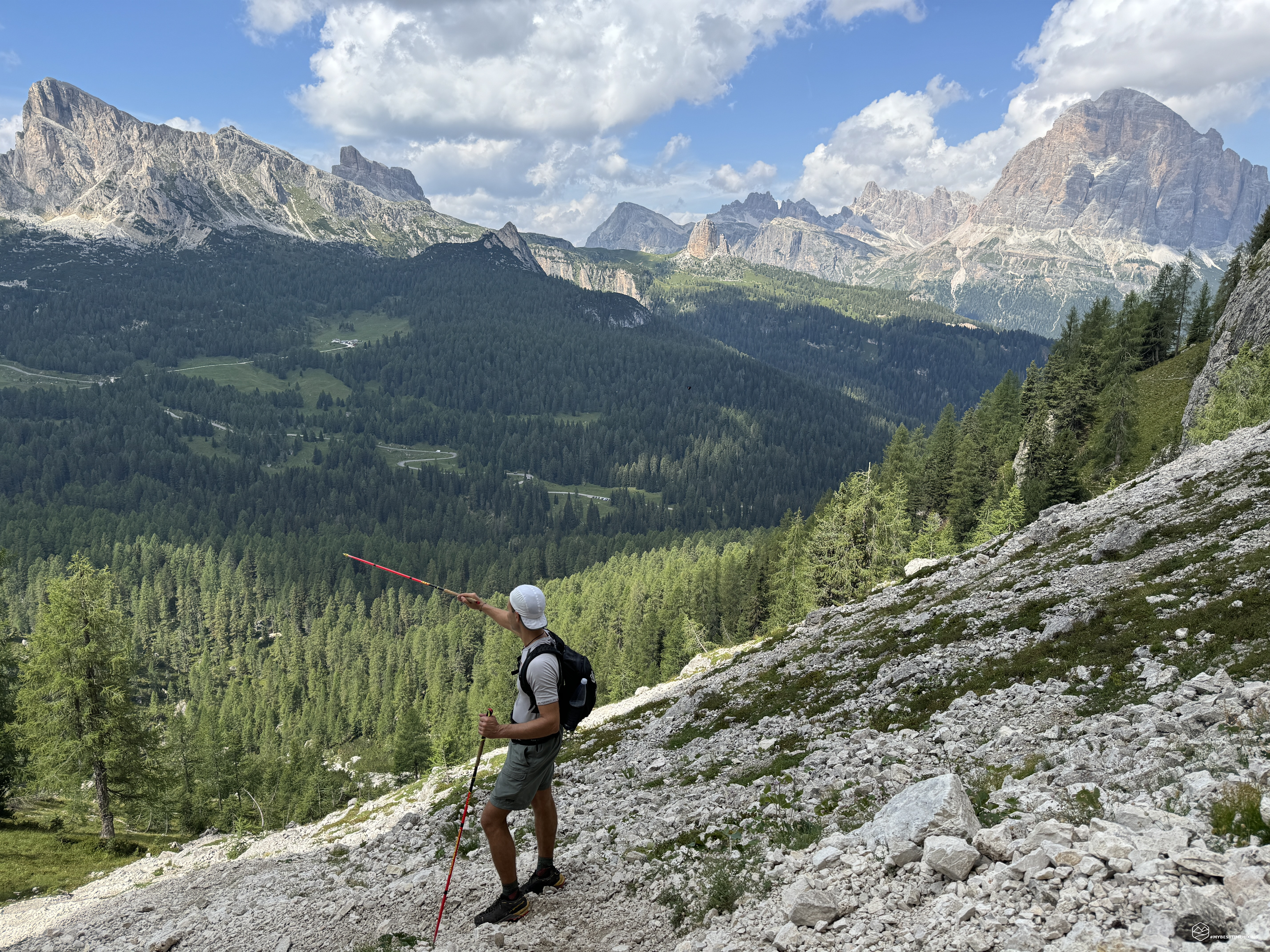
We proceed on this wonderful plateau, we seem to literally advance between earth and sky in one of the most characteristic places I have ever seen in the Dolomites. You have to pay attention to where you put your feet because the clearing is not so flat and there are some furrows in which there are rocks that could make it difficult to walk. I also recommend not leaning too far towards the edge: the walls that form the Lastoi de Formin drop vertically. An access for the descent is given by our next destination. A fork, also unnamed and not marked on the maps, that descends in correspondence with the Torre Marcella. This Dolomite tower is easily identifiable by its size and its horizontally cut summit. Once we reach the start of the fork, which we have named “Forcella Marcella”, we notice an immense stone man that unmistakably indicates the descent. A track is also clearly visible among the various boulders that make up the scree. A last look at the natural window that this magnificent place gives us and we continue on the descent.
The progression in the scree is easy, no technical difficulty and pleasant. The only danger could come from the Torre Marcella, a popular destination for many climbers. The route passes in some points exactly under the overhanging wall of the tower and you have to be careful of any rock discharges that may come from climbers. We soon reach the first vegetation and we approach the Giau pass again with the continuous noise caused by the countless motorcycles that are crossing it today.
We return to the vegetation of the Ciou de Ra Maza, we head north to rejoin and complete the ring. The forest still gives us great satisfaction. We notice an arrangement of large boulders, certainly belonging to a remote landslide, which also form here almost a pattern, with a defined logic. One of these, due to its position, was certainly used in the recent past, as a shelter for animals and people. Most likely in the Mesolithic era these places were also populated by the "Mondeval man" who is actually a stone's throw from here. To learn more about the Mondeval site you can find all the information on my blog: Alla scoperta di Mondeval
Continuing through the green meadows we also come across the discovery of a delicious source of pure water with a white flavor. Shortly thereafter, here is the last wonder of the day: the Ciou de ra Maza lakes. Pearls created by underground springs that give plays of light and unusual flashes for mountain lakes. A few steps from the first lake, which is usually dry, Diego points out to me a mysterious block of stones arranged in a straight line that no one has yet been able to explain. In this area, the legend of the Anguane was born: female figures linked to the mythological culture of Veneto and Friuli, who live in the streams or lakes of the mountainous territories. They are represented as spirits of nature, similar to the nymphs of the Roman world (probable original model of the myth). They are frequently described as young women, but other times they appear instead as beings half girl and half reptile or fish, capable of letting out loud screams (in Veneto there existed, until recently, the saying "Sigàr come n'anguana", scream like an anguana). In other stories they are old, thin, ghostly women, or nocturnal figures, who always disappear before those who meet them are able to see their faces… For those who want to delve deeper into this legend, I highly recommend the excursion made last year by Diego himself in this exact place: In search of anguane: exploring the Ciou de Ra Maza lake.
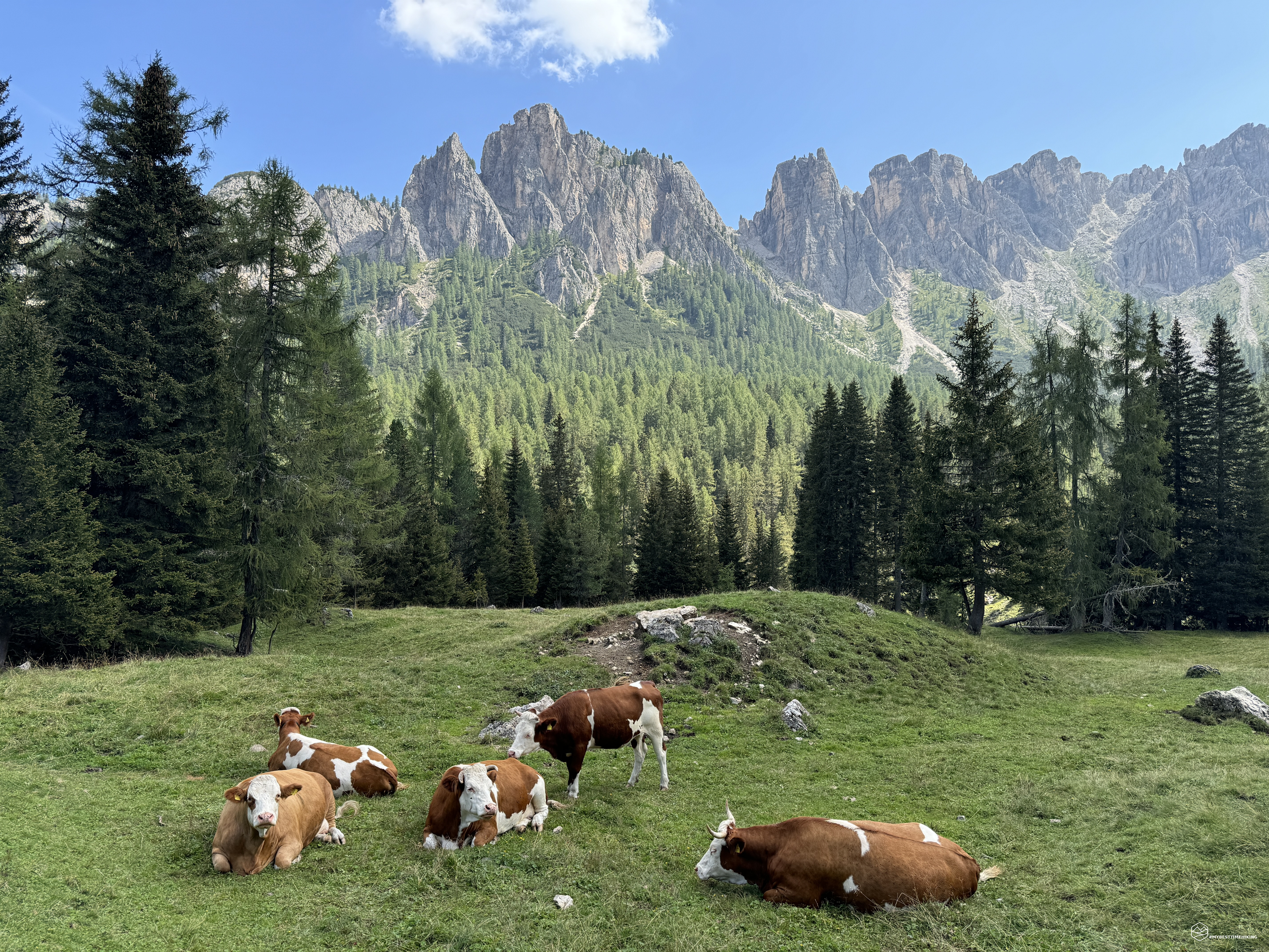
We are on the home stretch to conclude this fantastic circular tour; an anomalous swelling on the trunk of a tree welcomes us in the last clearing with cows grazing in front of the parking lot.
An unusual adventure, simple and without technical difficulties from an excursionist point of view. However, the area has no official paths, so it is mandatory to have an ability to observe and orient yourself to determine the right path to follow. The same caution must also be maintained on the Plateu dei Lastoni, and for this reason I identify the excursion with an EE grade. Certainly not an adventure for everyone, but for those who want to take a dive into the past, into our rural history, among unpublished traces and legendary rediscoveries. For those explorers who truly love the mountains and who prefer a "ravanage", albeit short, away from the masses that can concentrate at the Giau Pass!
For those who want to have an even more precise look at the technical level of exploration, you can visit Diego's blog here: Exploring the Giau Wall and the Lastoni di Formìn
DifficultyExpert hikers - are generally signposted itineraries but with some difficulties: the terrain can consist of slippery slopes of grass, mixed rocks and grass, stony ground, slight snowy slopes or even single easy-to-climb rocky passages (use of hands in some places) . Although they are routes that do not require particular equipment, equipped sections can be presented even if they are not demanding. They require a good knowledge of the alpine environment, a safe step and the absence of vertigo. Physical preparation must be adequate for a fairly continuous day of walking. |