

Today's adventure takes us to the Venetian Prealps, precisely in the Treviso area in Cison di Valmarino.
Together with our hiking companion Leonardo we reach the Peroz car park, passing the characteristic village of Cison and the memorial of the fallen Alpini, the Penne Mozze forest.
The itinerary includes a feast of peaks and ridges on one of the last days of winter where, at these altitudes, snow is now a fond memory.
Directly from Piazzale Peroz, a crossroads immediately appears before us where we choose the most direct route, apparently the most tiring, that is, the Asta path, CAI 987 trail sign. We enter an area where the vegetation is bare and immediately the tenor of the climb is felt. A continuous, accentuated slope, which forces us to catch our breath at fairly close intervals. We proceed in very close zig-zags, passing rocks and short panoramic clearings. We soon reach the characteristic stretch of this variant: the equipped route. A succession of short metal cables (about thirty metres) which facilitate progression on some slightly exposed but never dangerous rock leaps. Of course, the hiker who ventures into this stretch of trail must be prepared and have a steady step. The climb gives us a magnificent aerial view of the surrounding peaks as we proceed in this gorge between slag and bare rock.
In this part of the path we also encounter small ticks. The entire area described in this adventure must be carefully evaluated for the presence of ticks. Years ago I remember descending from one of these tracks and finding myself "spiked" by about ten ticks. Foresighted, Leonardo and I sprayed ourselves liberally with a specific repellent for these parasites.
Continuing, reaching the apex of the rocky gorge, rejoining the Costa del Vent path, which can also be followed from the Peroz car park and a valid, simpler alternative to the Asta path. We immerse ourselves in a beech grove which still lets the warm rays of the sun pass through. The route continues with short and narrow bends, always proceeding practically in a straight line in the direction of the Loffs. We also intersect path 991 towards the Foran pass which we will reach later. From here there is very little left until today's first stage.
We go out onto a small grassy plateau, we notice a large raised wooden bench that heralds the arrival, bypassing a rocky coast, at the legendary Lòff bivouac! In the Cimbrian language “lòff” means “wolves”, hence the translation bivouac of the wolves, a nickname which, among other things, is given to the inhabitants of Cison di Valmarino. The bivouac is set against the rock face of the Crodon del Gevero, in front of which a beautiful terrace allows you to enjoy a splendid panorama of the Cison valley.
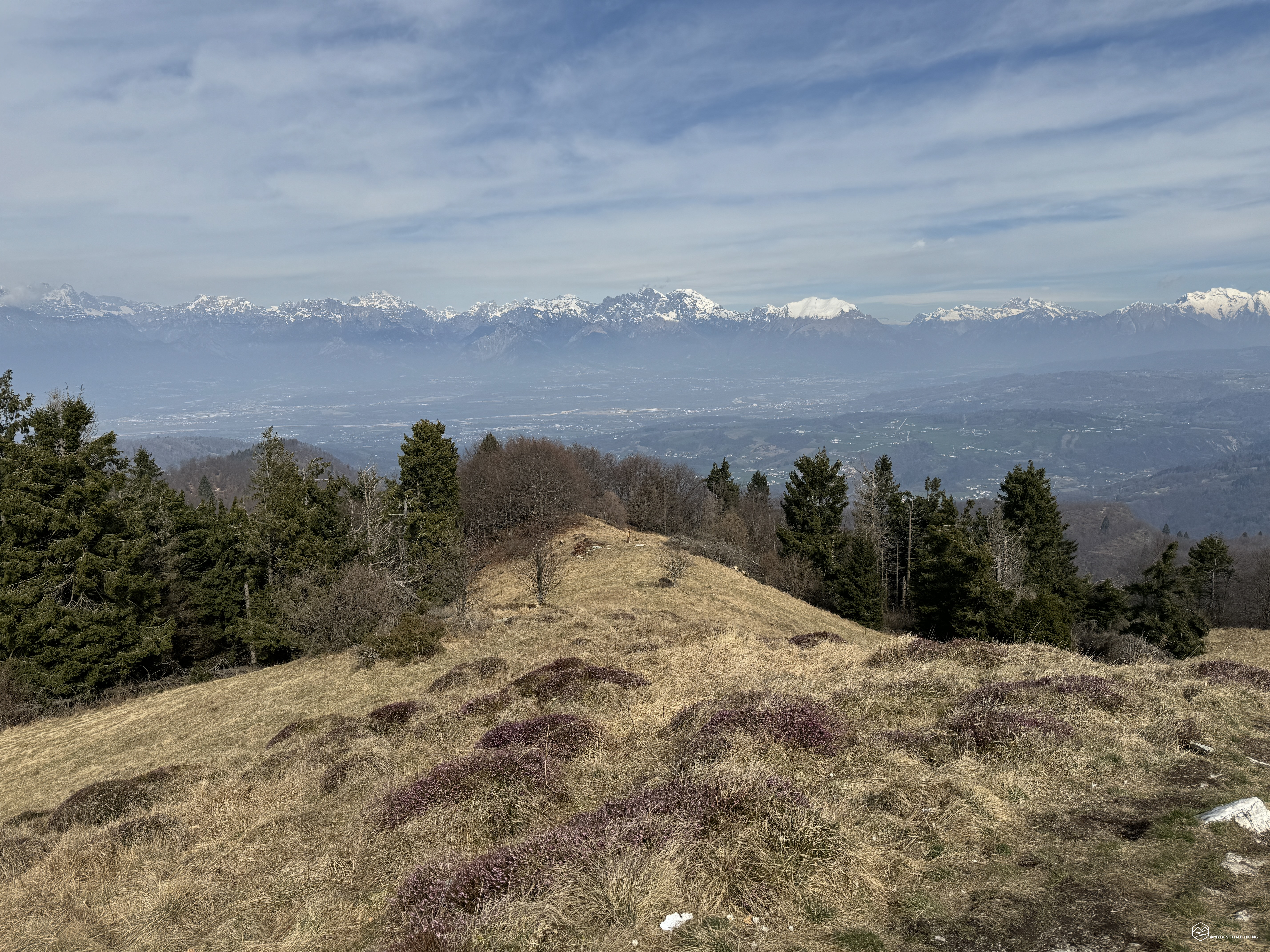
At the crossroads of many paths, the Lòff bivouac is an obligatory stop. In fact, here we find several people resting to continue an itinerary different from ours. We briefly retrace our steps until we come across the deviation at the height of the wooden bench indicating the summit of Valon Scuro. A clearly visible path on the grassy cliff allows us to reach the crests in a few minutes. Once you reach the saddle you can immediately notice a spectacular view of the last Venetian Prealps such as Col Visentin and Col Nudo, and then get lost in the more typical Dolomites such as Cima dei Preti, Schiara, Pelmo, Civetta, up to Agnèr!
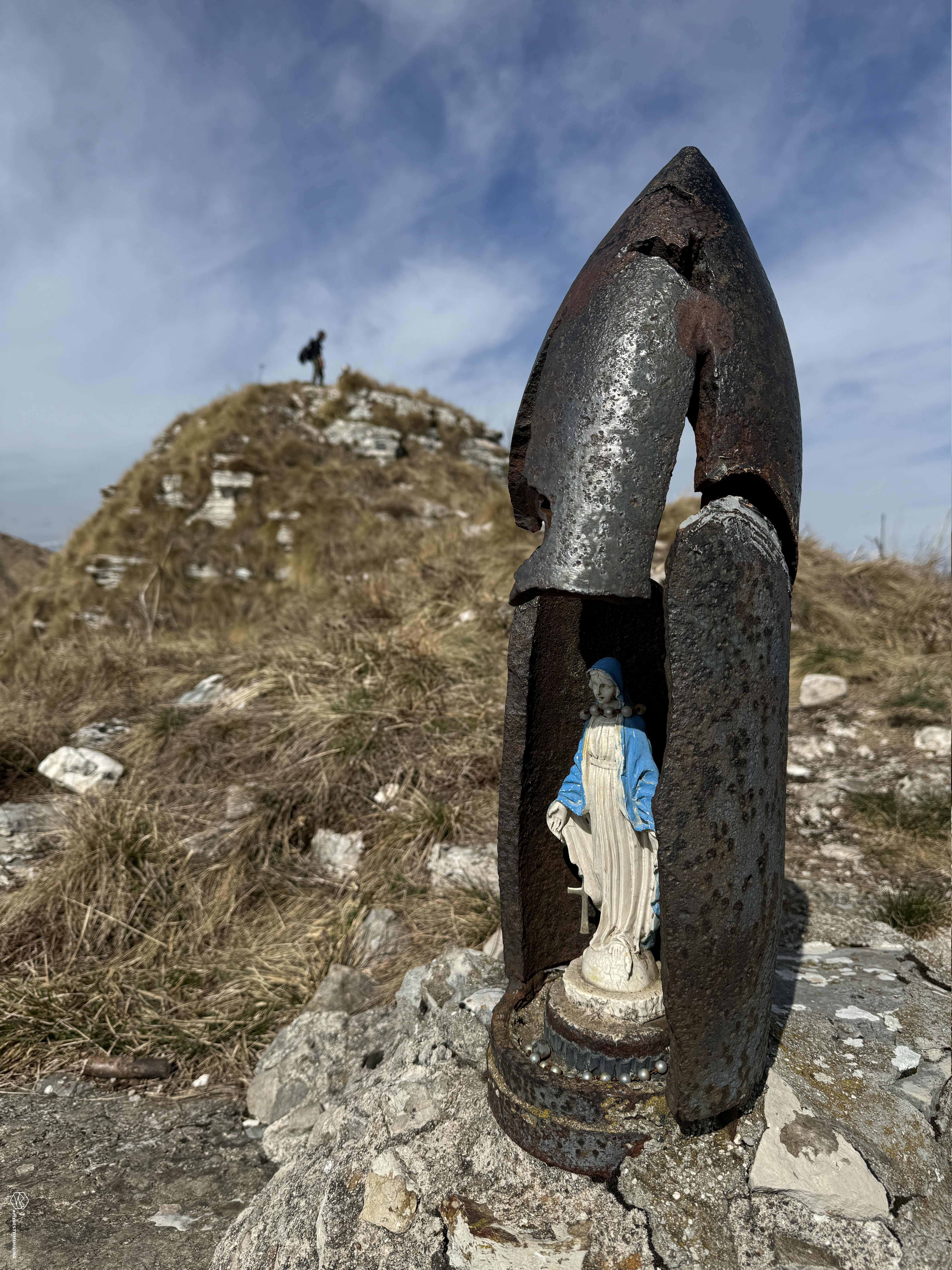
We go up to the nearby Crodon del Gevero (in Venetian "hare"), a particular "stone" prominent towards the south which is truly characteristic and worth the climb also for the presence of a small Madonnina set in a bomb splinter from the First World War which seems to have been created specifically as a capital. There is also the summit book below the Madonnina, at an altitude of 1250m.
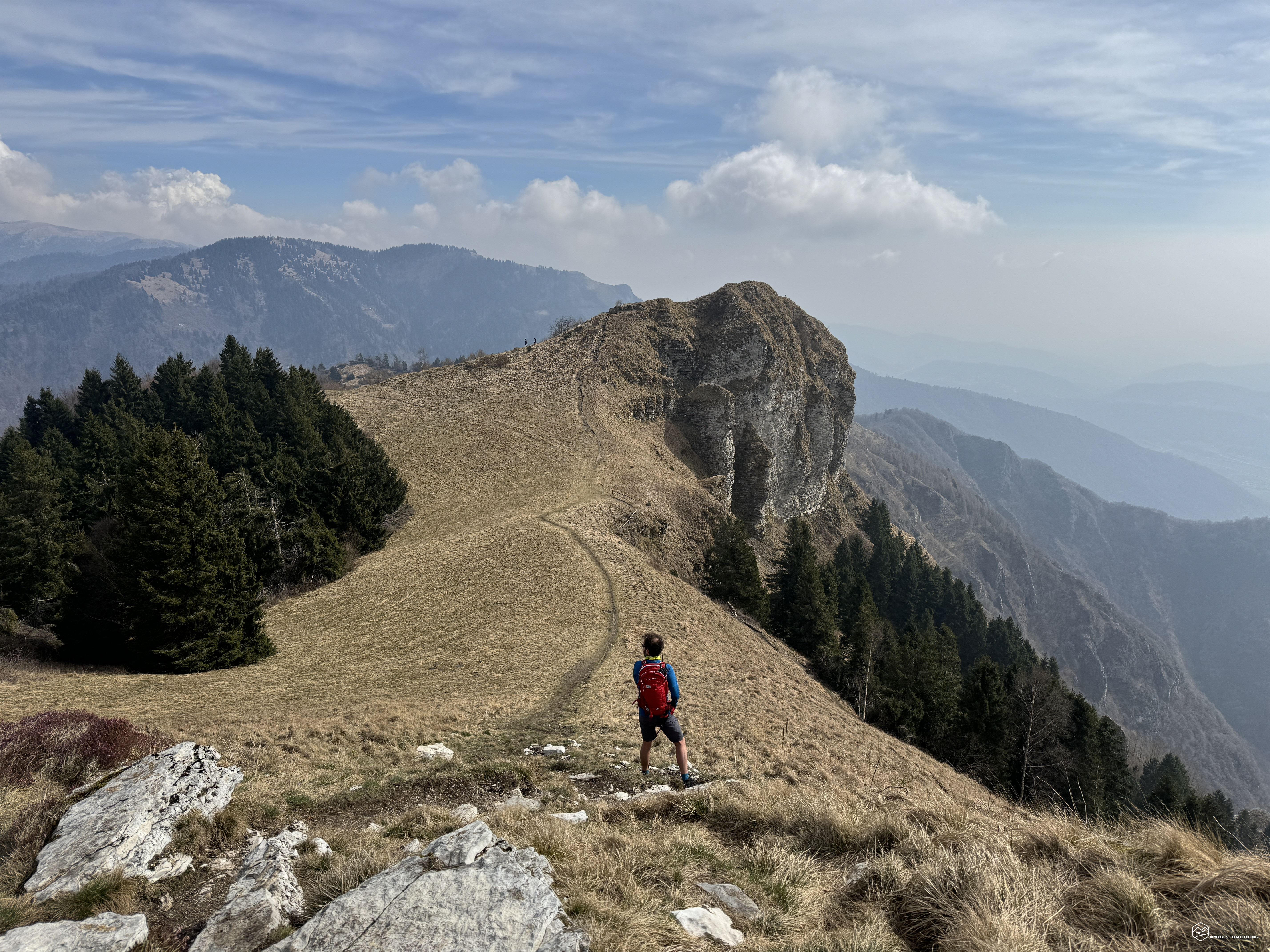
We return to the ridges and follow them entirely in the direction of Cima Valon Scuro (or Cima Vallon Scur or “La Pala”). Definitely wide, pleasant ridges, never exposed but which give a beautiful feeling of freedom given the wide range of vision between the Cison valley and the majestic Valbelluna. In about ten minutes we also reach the second peak: the Vallon Scuro.
At an altitude of 1280 metres, a classic cross indicates the summit. You continue to have a splendid panorama in the direction of Follina and the Soligo plain. The peak can also be easily reached from the Trichiana area with a quicker route.
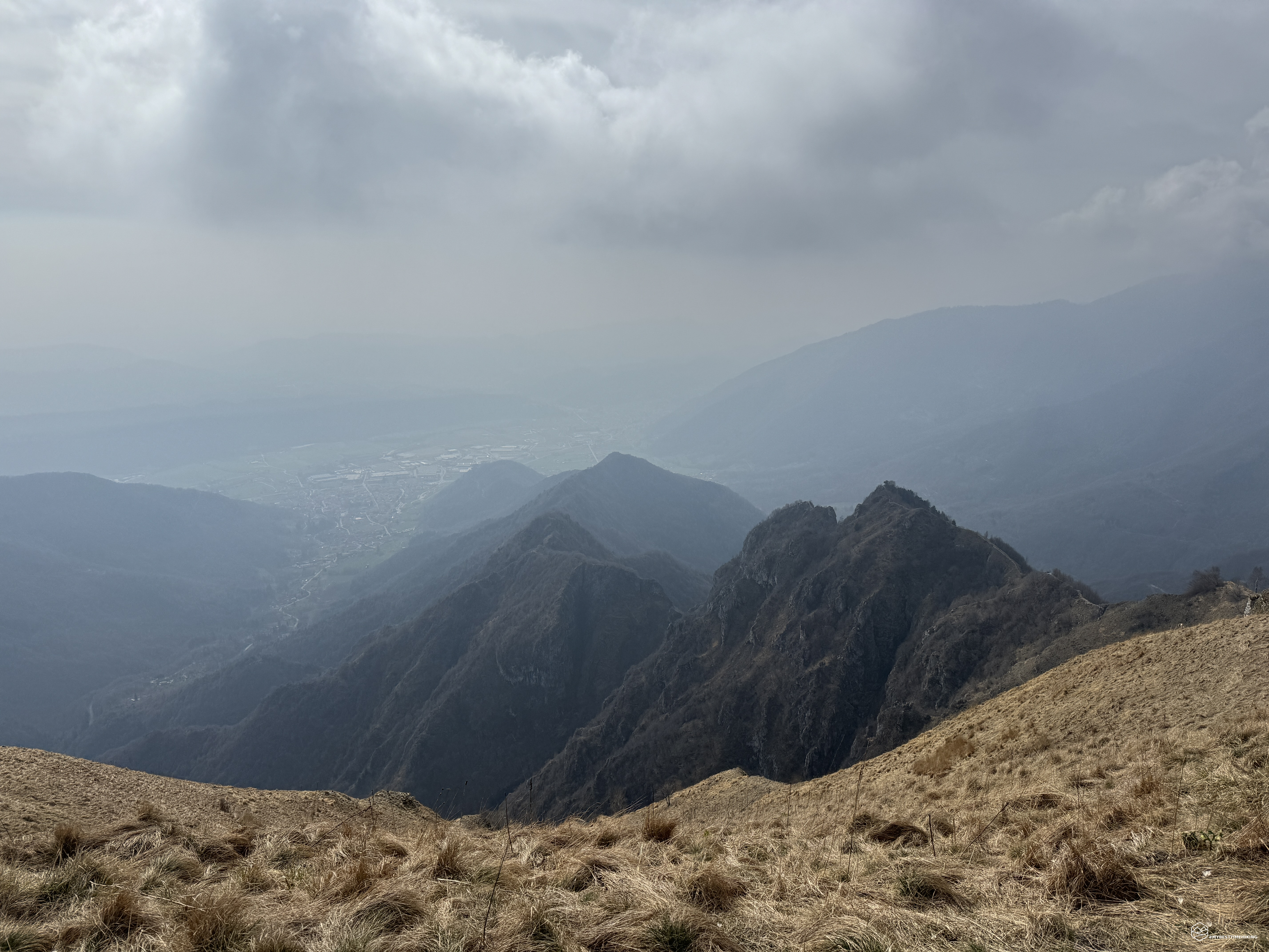
We leave the Vallon Scuro and begin a steep descent towards the Foran pass. In front of us the next objective and the highest peak of the day: the Col de Moi. We descend quickly until we reach the fork and choose the direct route along the ridge, on the CAI 991 path, to reach the summit. So you go back uphill, the last 300 meters of positive altitude difference.
A series of clouds begin to gather around us, bringing more of a thick mist. The crest of the hill is pleasant even if, after having already covered 700 meters of altitude difference and a refreshing descent, it seems like a particularly hard climb. Several paragliders circle above our heads and, in fact, the wind begins to be more and more present, incisive and biting. And finally here we are on the top at 1358 meters: Col de Moi!
Date
17-03-2024
Distance
8.12 KM
Hike type
Hike
Ascent
1025 mt
- Mountain
Col de Moi
- Address
Cison di Valmarino, Veneto, Italy
- Altitude
1358.00 m
- Refuges
- Information
The historical significance of this peak is very interesting. In the past, when farmers went to mow hay on the ridges of this mountain, it often rained and consequently it was always seen and labeled as "wet", "humid". Obviously the nickname was given in the local language, in fact in dialect "moi", "moio" identifies something full of water, decidedly humid.
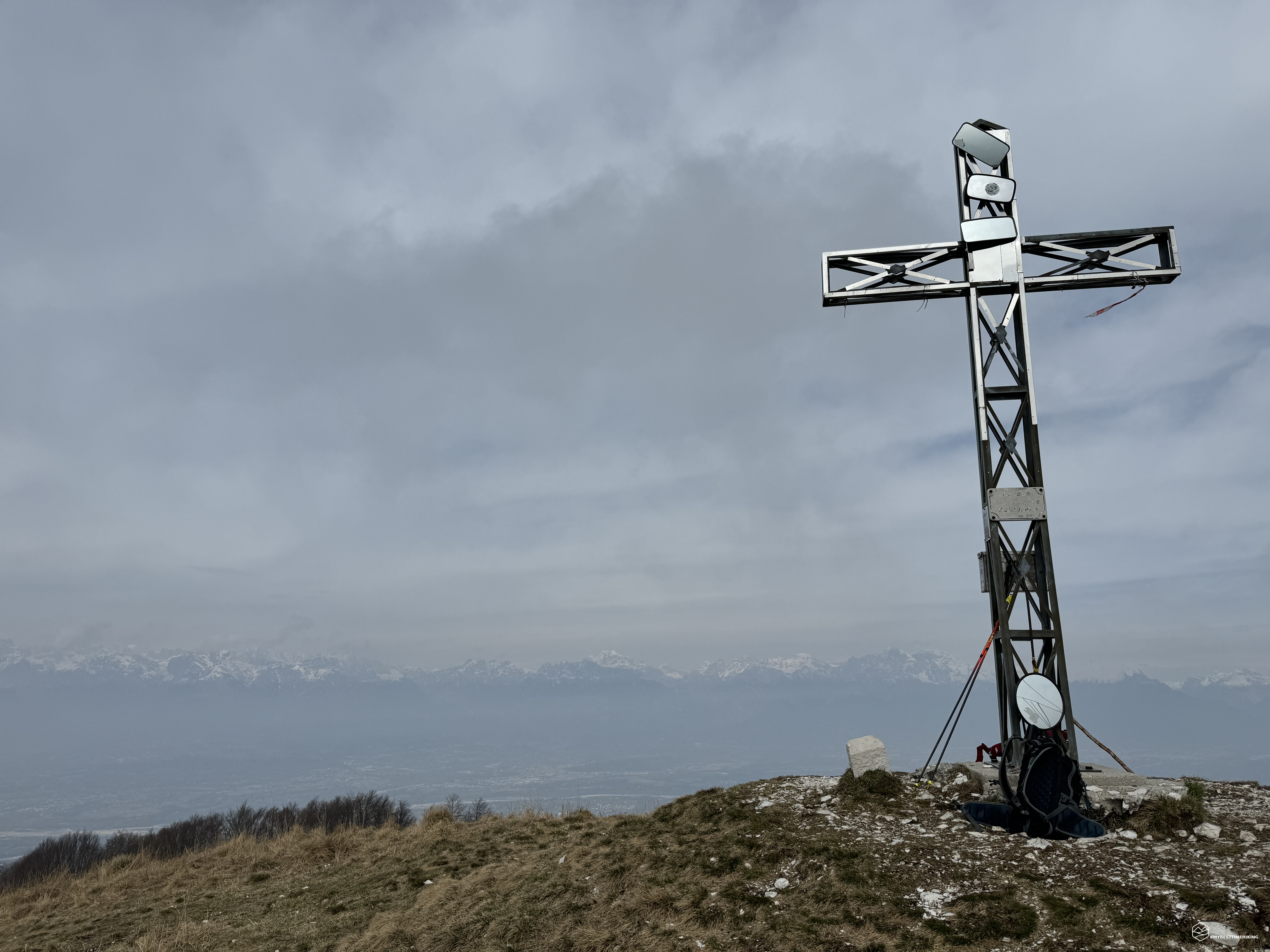
At the top of the Col de Moi there is a particular steel cross filled with many mirrors and mirrors. Given the foggy day and the presence of many paragliders, it is easy for me to understand the reason for the installation right on the cross. Unfortunately the weather doesn't allow us to observe the view from this point, the decidedly cold wind forces us to take a quick break and then descend towards the Foran fork.
From here we take a shy path indicated with a slender wooden pole and the plate engraved with "TV1" and just below "E/7". This track is known as the "Sentiero dell'Arco" and right from the start it is an exceptional sight! A beautiful, fun crest that allows you to walk almost on a razor blade without particular dangers. Some points are delicate due to the presence of short rocky crags and therefore I recommend it for well-prepared hikers. We proceed first at altitude, we descend meeting a small saddle where on the right we can continue towards Mount Schiaffet and Val del Diavolo with the fork of the same name, where in 2020 we carried out another very exciting excursion. We continue on the descent and are captivated by the view of the place that gives its name to the path: a majestic rock arch that creates a natural window onto the valley. An arch certainly carved out by water over the millennia and where it still flows, giving a pleasant refreshing rain.
We proceed quickly to the conclusion of this ring, intersecting a new track called "Sentiero del Pissol". A path that first winds through a beech grove, then skirts the rocky walls of the same confirmation of the arch. Then a wide ledge turns, which in any case appears sheer, in the most protruding section, towards the Cison valley. A succession of short and steep hairpin bends make us lose altitude quickly, some passages where you need a steady step and a point where you need to climb down a couple of meters are not trivial.
We begin to hear the sound of water, the path becomes increasingly flat and simple. We pass the deviation that goes back towards the Devil's Valley and continue in the direction of the sound of the water. We soon reach the Pissol waterfall: a splendid waterfall of approximately 5 meters which pours fresh water into the valley which allows for lush flora from this point onwards. It was no coincidence that at first we only saw brushwood, rocks and shavings of grass still the color of hay. Here, however, the life given by this waterfall allows you to enjoy an early Spring. We refresh ourselves and enjoy a break in this place of complete relaxation.
We follow the path at the edge of the stream created by the Pissol and, within a few minutes, we emerge at Piazzale Peroz, concluding this magical excursion.
An adventure that can be done in all seasons, spring and autumn are recommended. The choice of paths in this area allows you to choose the best tracks based on preparation. Today's excursion, replicated in full, I recommend to prepared hikers, even if not exactly experts, they must still have a steady step and a sense of direction, especially for the Arco path. By opting to depart from the San Boldo pass instead, the Loff bivouac can also be reached by mountain lovers without particular preparation.
From what you have noticed, this adventure has notable references to animals and the geological confirmation of the place. I therefore allowed myself to imagine this adventure also as a fairy tale for children:
”In the thick woods, the hare Gevero felt the danger approaching. The wolves, with their hungry eyes, were trying to penetrate his Crodon del Gevero. Without thinking twice, Gevero fled, seeking an escape route through the Vallon Scuro. Her small form moved nimbly across the ridge paths as her heart pounded in her chest. After passing the Vallon Scuro, she Gevero found a temporary refuge on a humid hill called Col de Moi. Here she hid, hoping to escape the threat of the wolves. After spending some time in safety, Gevero decided to continue his journey. Following a ridge path, she passed through a towering arch of rock that rose toward the sky. With each step, the tension faded and hope was reborn in his heart. At the end of the path, Gevero found himself in front of a small waterfall that fell gently between the rocks. With a sigh of relief, Gevero approached the waterfall, letting the cool water refresh his tired body. Lying at the foot of the waterfall, Gevero closed his eyes, finally at peace after escaping from the wolves. Now, surrounded by the beauty of nature, he could finally relax and regain his strength."
DifficultyExpert hikers - are generally signposted itineraries but with some difficulties: the terrain can consist of slippery slopes of grass, mixed rocks and grass, stony ground, slight snowy slopes or even single easy-to-climb rocky passages (use of hands in some places) . Although they are routes that do not require particular equipment, equipped sections can be presented even if they are not demanding. They require a good knowledge of the alpine environment, a safe step and the absence of vertigo. Physical preparation must be adequate for a fairly continuous day of walking. |