


Gloomy day. With Giorgia, from our Hotel Gran Paradiso in San Cassiano in Alta Badia, we still choose to embark on a new adventure. This time the destination is in our home region, Veneto. Passing through Corvara, through the Campolongo Pass, we return to the province of Belluno. We park the car astride the pass and get ready, also to resist the adverse weather, with today's goal in mind: the Bec de Roces!
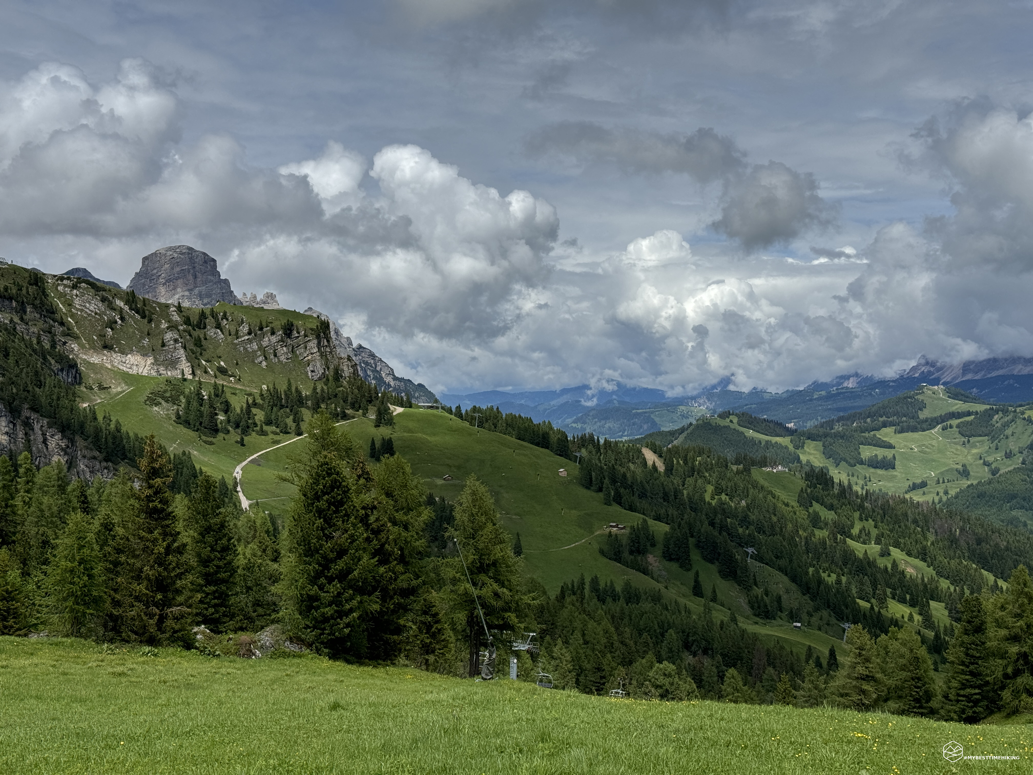
We take the CAI 636 trail sign on a dirt road with a steep slope. In some places there is also the risk of slipping given the compactness of the gravel together with the steepness of the road. It is a panoramic route that allows you to enjoy the peaks of Alta Badia such as Sassongher and Sass de la Crusc. In about 40 minutes we rise over 200 meters in altitude, reaching the plateau in front of the Bec de Roces refuge.
A magnificent view opens up on the Queen of the Dolomites, in a Dolomite landscape which also sees among the peaks those of Cadore with Pelmo and Civetta, today immersed in an almost frightening darkness. At the refuge, which can also be reached by convenient chairlift from the Albergo Boè before the Campolongo pass, you can see the characteristic mountain conformation of the Bec de Roces. A break at the refuge is a must with a refreshing skiwasser.
We continue the excursion and head towards these pinnacles, spiers that stand out slenderly towards the sky which today gives us its gray colour. The dolomite conformations create an image that is always different depending on the point of view. Just a few steps are enough to admire a different facet, an ever new point of view. Path 640 (formerly 636) starts immediately behind the refuge, at the arrival point of the chairlift. The thematic route for the little ones called "Bearlock Holmes: in search of Bec the bear" also begins here. All the information regarding the route is available on the refuge website (you can find the link in the information box on this page). In short, it is possible to collect the route card at the Arabba Tourist Office. On the path you can discover all the curiosities about the life of little Bec and his family using the special stamps that can be found hanging from the Bears along the route. Once you have found all the bears, once you return to the Bec de Roces refuge you can hand in the card and receive a nice prize!
Date
26-06-2024
Distance
5.09 KM
Hike type
Hike
Ascent
443 mt
- Mountain
Bec de Roces
- Address
Passo Campolongo, Veneto, Italy
- Altitude
2236.00 m
- Refuges
Rifugio Bec de Roces
- Information
The track winds between small rocky crags and patches of mountain pines. It must be said that this route is also suitable for little ones who want to walk and are enterprising in some slightly less traditional points. The path is varied, continuously uphill, never boring with the view of these truly fantastic spiers. In some ravines it is also possible to capture splendid views towards Arabba with the legendary Marmolada behind. At Plan da Fistì you enter a parallel world, with lunar soil between crashed boulders, cracked pinnacles that seem to be supported by invisible threads. We then exit onto a clearing of baranci where today the low clouds chase each other revealing the completely snow-covered Sella group, even though we are almost in July.
We arrive at an altitude of 2236 meters at a large monolith with an adjoining dry stone wall which allows us to have a dry place sheltered from the strong gusts of wind that characterize this nameless fork. Here we cross the path coming from Arabba, the CAI 637 which is part of the CAI's Sentiero Italia which entirely connects Italy in one large and mythical path. We take this path among cushions of colorful flowers that liven up this day that does not want to turn into good weather. At our side the rocky walls of the Sella group stand out with the Boè peak still hidden by some cloud cover. The track is always clearly visible, grassy stretches alternate with decidedly more rocky and, at times, slippery moments due to streams of water. At these points it is essential to take a firm step and pay attention, we are still in a safe place but close to the sloping walls of Ciadinel. We pass this delicate area constantly admiring the Queen and enjoying the Bec de Roces from a new perspective.
We soon reach the CAI 636/B deviation which, through a thicket of mountain pines, first takes us back to a dirt stretch used for downhill. Here I recommend going along it quickly to avoid crossing mountain bikes shooting downhill. We return to the exclusive track for hikers and return to the plateau of the Bec de Roces refuge, just in time before the rain.
A restorative break at the refuge is highly recommended given the delicacies available, the excellent quality of the products and the excellent care taken in preparing the dishes!
The sun finally peeps out and we can enjoy a few minutes of relaxation immersed in the warmth of the rays that we hadn't seen until now. The sky is torn apart and we can admire part of the white Marmolada glacier, passing through the window of Porta Vescovo above Arabba: a spectacle! With these colors enlivened by the sun we return towards the Campolongo Pass enjoying the new panorama that had inhibited us on the way out.
The Bec de Roces refuge is an excursion suitable for everyone, for the lazy ones I also remember the possibility of reaching it by chairlift. For those who want the complete experience I recommend exploring the Bec de Roces in a place away from the tourist masses in an almost magical environment. I also recommend this variant to everyone, the important thing is to have a minimum of ability on rough terrain and not to be afraid of some dives among the mountain pines. The views repay all the efforts and the excellent cuisine of the refuge will certainly make you forget the effort!
DifficultyHikers - Itineraries on paths or evident traces in various types of terrain (pastures, debris, stony ground ...). They are generally marked with paint or cairns (pyramid-shaped stacked stones that allow you to identify the route even from a distance). They can also take place in snowy but only slightly inclined environments. They require the equipment described in the part dedicated to hiking and sufficient orientation skills, walking training for a few hours. |