.jpg)
Summer of San Martino, what better place than to retrace the legendary places linked to this Saint.
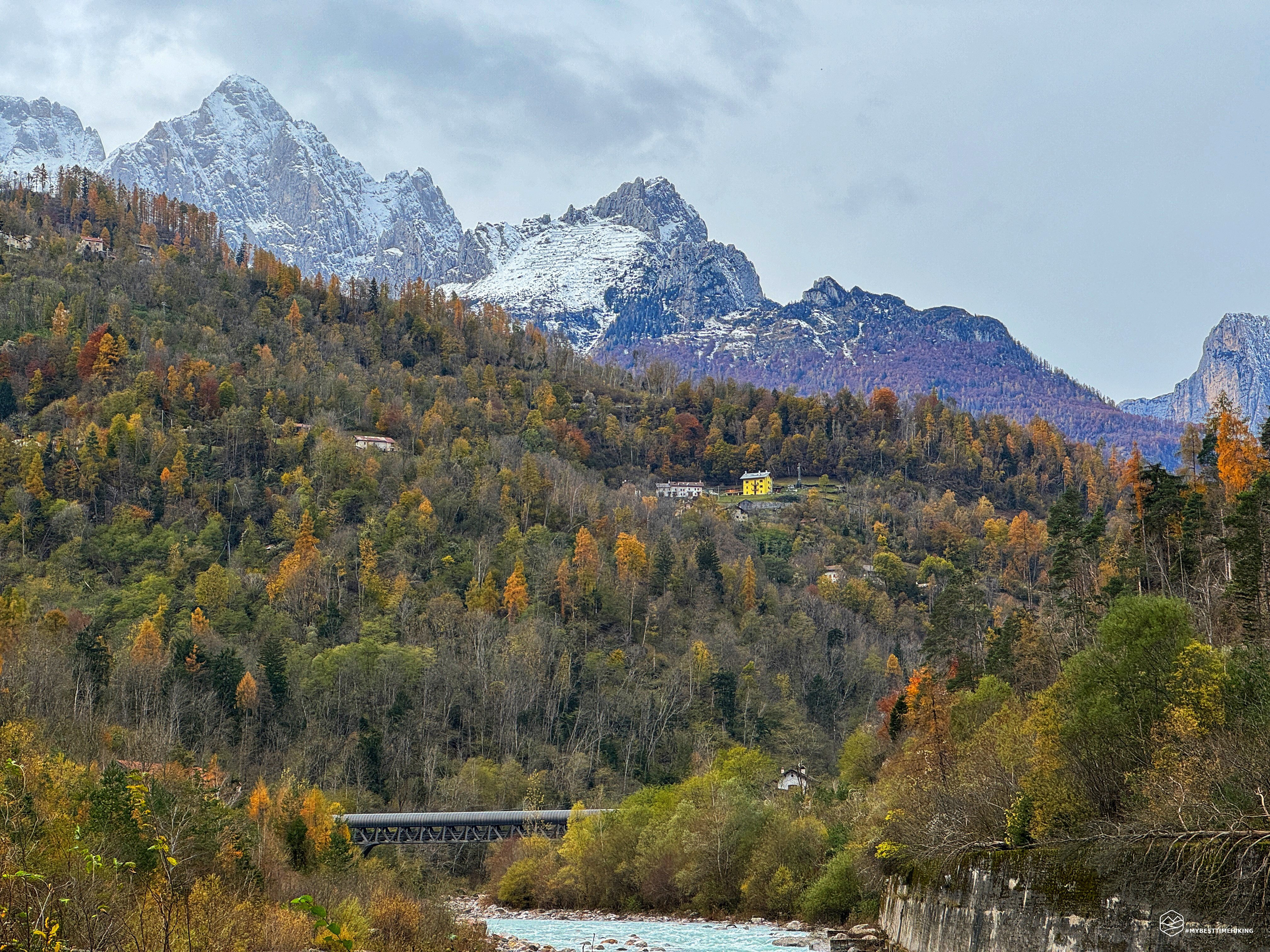
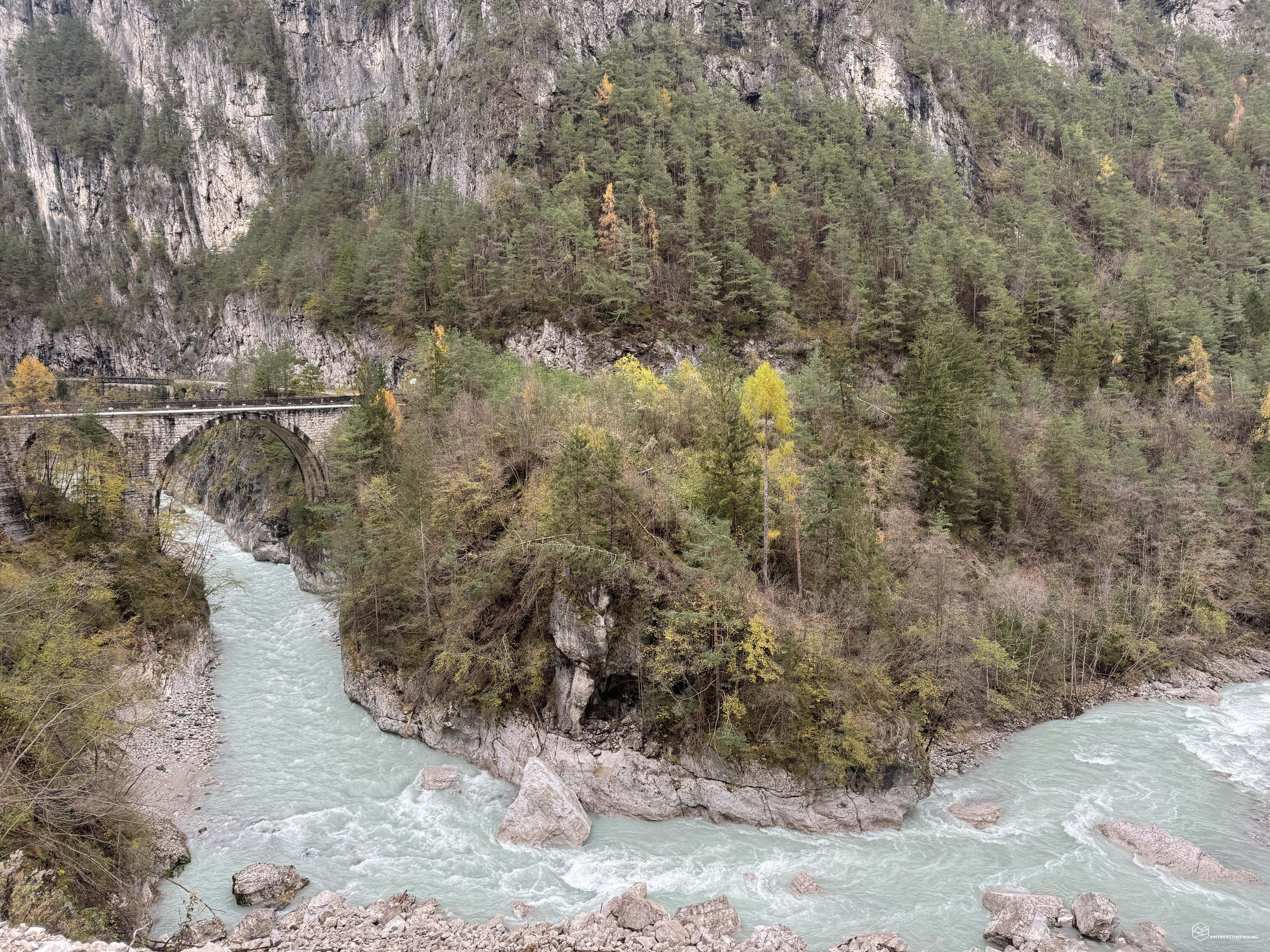
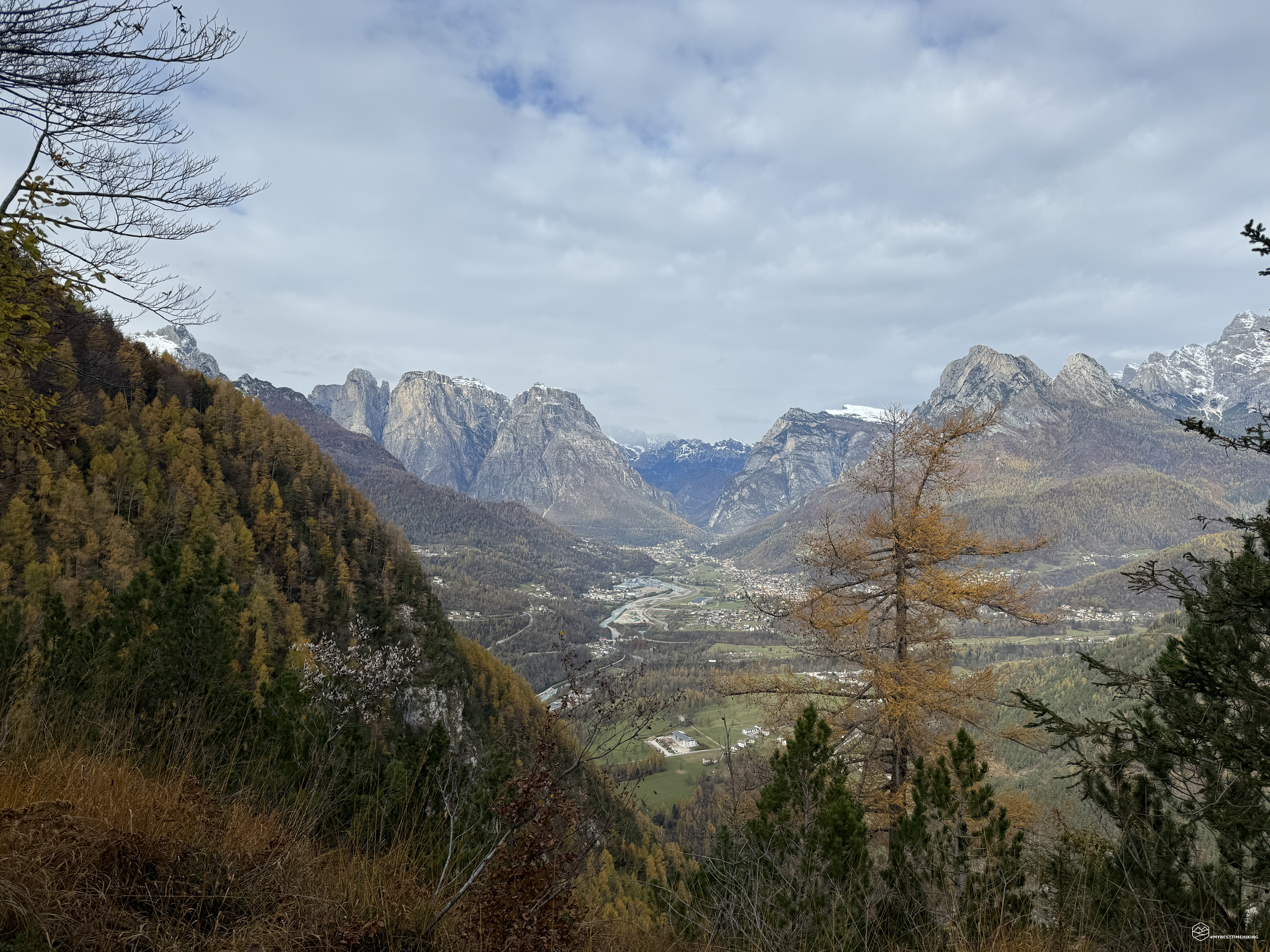
Leonardo, my friend of many adventures, and I are in the Agordino area, more precisely in La Muda. We park the car at the no-traffic sign and walk along the old road before the tunnel. We are on the former state road, still asphalted, immersed in the humid shade of a mid-November morning. On the sides, on the left, Mount Pizon and, on our right, the final crags of Mount Zelo. The impetuous Cordevole torrent of a hypnotic green water divides it all.
We soon reach the first stop, the former roadman's house in front of the Pont de i Castei. First surprise: in front of us a large landslide blocks our way with imposing cliffs that flow into the Cordevole. The roadman's house can be glimpsed behind this stony wall. We pass the barrier, still unstable, and head towards the bridge, from which we should have the best view of the road ahead. For this adventure, in fact, I read up on the 2005 book by Teddy Soppelsa entitled “Excursions in the Dolomiti Bellunesi National Park”, itinerary number 7, in which the area is described: “ […] directing your gaze towards the west above the roadman's house, a curious monolith called the Panocia (850 m) is visible, which stands out in the center of an ancient landslide, now colonized by mountain pine and birch groves, which fell from the slopes of Col Pizòn (1482 m) probably in course of the landslide which, as mentioned, would have blocked the course of the Cordévole torrent, creating a vast lake basin. […] A few tens of meters to the left of the roadman's house you take the beautiful military mule track (closed to motorized transit) which climbs gently along the steep northern slopes of the Piz de Mezodì (or Pizón).”. Analyzing the place we do not notice any monolith in the shape of a "Pannocchia" and, even more worryingly, we do not see any military mule track... Further investigation subsequently found that both the monolith and the mule track were swept away by this powerful landslide which occurred on 17 February 2022 between 4 and 5 in the morning. A little discouraged by this discovery, aware of the fact that the adventure would soon end, we observed the Ponte de i Castei with its splendid view of the stream and recalled an ancient legend of this place, the Tagliata di San Martino, linked precisely to the Saint.
Soppelsa describes it very well: “According to a legend in this place, also known by the nickname “taiada de San Martin”, Saint Martin performed a miracle. In fact, it is said that, to save a child who fell from the boat into the waters of the lake which then covered the Agordo basin, the Saint cut the downstream barrier with his sword, causing the water to flow out and thus saving the child, who had the name Agordo. . The legend of San Martino, as sometimes happens in popular mythology, finds a solid historical foundation here. Several scholars in fact agree in affirming the existence of a lake, formed in the Neolithic between 5780-6000 years ago, which extended from Listolade (south of Cencenighe Agordino) to the gorge of the stréta dei Castèi, for a length of approximately 8.5 km. Among the hypotheses on the origin of the lake, the most likely one seems to be a landslide that fell from the slopes of the mountains located on the orographic right and left of the Cordévole near the Pónt de i Castèi.”.
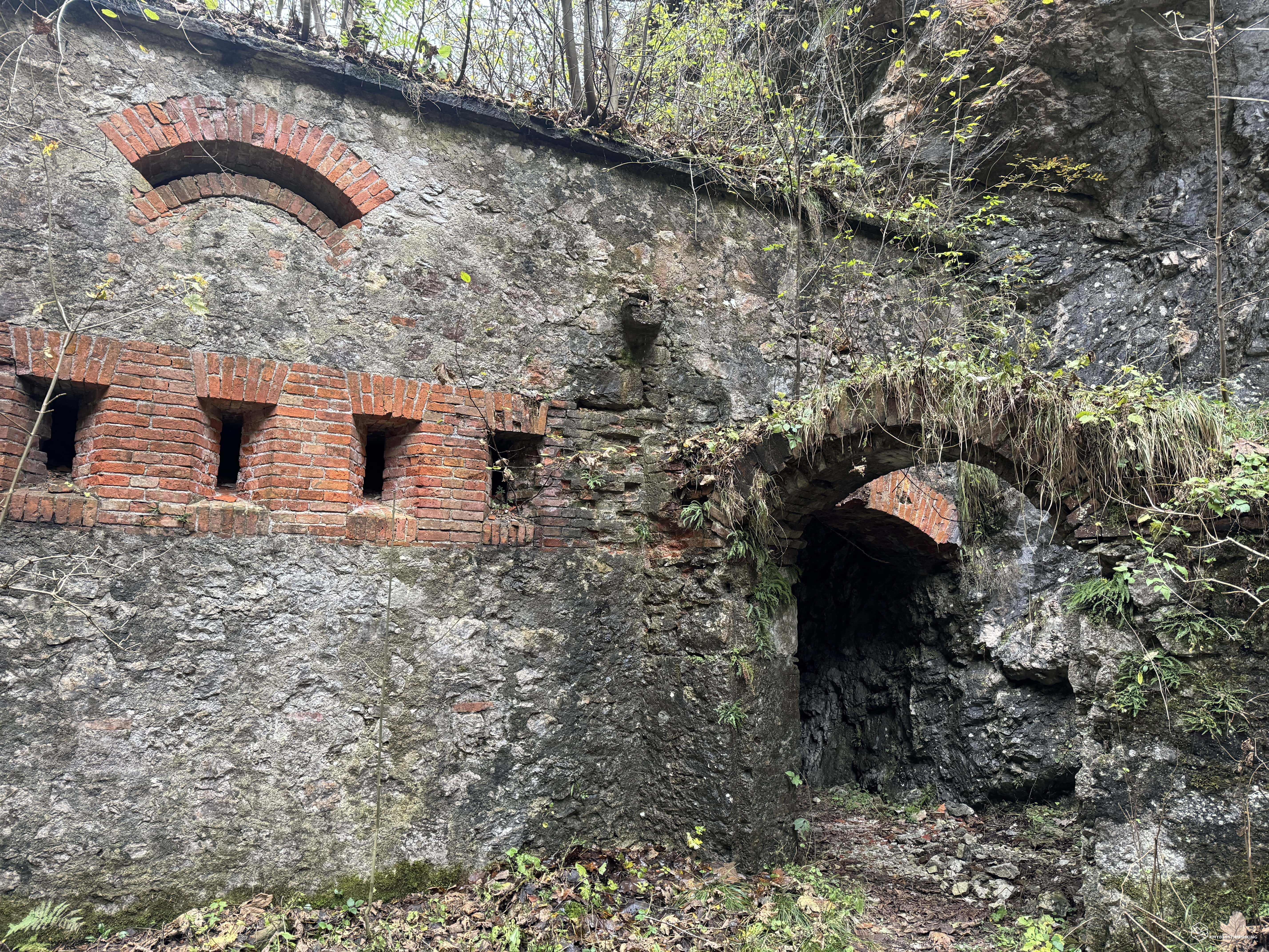
After having almost relived this legend by observing the deep cut in which the Cordevole now flows, we visit the remains of the lower fort which stand out slenderly on the orographic right of the stream a few steps from the roadman's house. Here, crumbling tattered walls indicate the presence of an old bastion called Forte di San Martino or, also, Tagliata del Sasso di S.Martino. The construction, which began in 1883 and ended in 1887, already represented a strategic point at the time for defense against possible incursions by the Austrians. In the First World War, during the Italian retreat, it was blown up in 1917 to prevent the Austro-Hungarians from using it in the event of an advance. In the Second World War it was partly restored (presumably the upper part, which we will see shortly) by the Germans as a defense against a possible American incursion from the South. Fortunately, the structure has never been involved in any war.
A little dejected, we are about to retrace our steps and when I am about to think about returning to the car, I try to walk along a very dense grassy stretch that turns from the fort towards the stream. I go down a couple of meters towards the ravine and notice with surprise two bright red stamps painted on a tree in front of me: all is not lost. I call Leonardo back and proceed into the unknown. Initially this track is surrounded by tall grass and crashed trees, but step by step we come across some red and white bands tied to some dangling branches. Other signs on large trunks leave no doubt: although it is impervious, this is a new route after the disastrous landslide that obliterated the old mule track! We proceed safely on this grassy cliff overlooking the Cordevole ravine below us. We move towards the West where the track now climbs steeply into the woods. We slide on slippery and uneven terrain, the crashed trunks help us in our progression. The path is truly covered in red signs. Soon we arrive at a clearing with grass that reaches our hips. A well-maintained and easy road on our left and, in front of us, the (high) Fort of S. Martino in all its beauty.
The historian Ottone Brentari identifies it as the "Guard Corps" and describes it impeccably in his book "Historical-Alpine Guide of Belluno-Feltre Primiero-Agordo-Zoldo" of 1887: " [...] began in 1883, finished in 1887. The grandiose wall supporting the road was erected in 1885. - From the fort, going up a small path on the left, in 5 minutes. you reach the "Guard Corps", a small fort that closes the narrow gorge between the Sasso and the mountain that rises on the right of the Serrade Valley.”
We immediately notice the recent reinforcements on the windows which, most likely, were carried out by the Germans in 1945. We put on the extremely necessary headlamp and enter to explore the fort which exudes history in every brick. We follow it for its entire length where, at the end, we notice a small tunnel and it gets lost in the pitch darkness. We are here to explore and therefore, off into the unknown, into the darkness pierced only by the glare of my headlamp. The tunnel is really long and winding, slightly downhill. I begin to express the idea of going back when I feel a spray of fresh air coming in front of me. Shortly after, the exit is on the left! We thus emerge a few dozen meters behind the fort towards Val Carbonere. A beautiful discovery that galvanized us. We return to the fort and directly under a characteristic portico we return to the front part.
We decide to follow the marked path that should have led us directly to the fort to find out where the landslide interrupted its path. Here too we find a short tunnel that leads us to the mule track a little further on. The track gradually becomes wider and more comfortable. We arrive at the crossroads with the CAI path 874 and proceed slightly downhill towards the south. We thus arrive at the interruption of the path devoured by the landslide of the "Panocia" del Pizon. We notice a faint trace on the extreme edge of the landslide that leads to the stretch of mule track where we are at the moment. The fact remains that the variant described above is the most comfortable and safest way to reach the San Martino fort.
Date
12-11-2023
Distance
19.14 KM
Hike type
Hike
Ascent
913 mt
- Mountain
Sasso di San Martino
- Address
Agordo, Veneto, Italy
- Altitude
1056.00 m
- Refuges
- Information
We retrace our steps and at the crossroads we choose the route towards the East towards Pianaz. At the first bend to the right you can see a majestic bas-relief in the rock which should represent the coat of arms of a brigade, most likely the "7th Alpini", given the number imprinted in the upper part of the figure. We proceed steadily uphill until we reach the series of three tunnels that pierce this Pizòn ridge. The tunnels were built relatively recently, following the Great War. In fact, before there was an old military road created in 1915 that followed the side of the mountain further down the valley. This is still passable, it can be seen at the exit of the first tunnel and the beginning of the route can be identified at the exit of the third tunnel on the right. The first of the tunnels is the longest and requires a torch. Inside, various longitudinal cracks allow the linear progression to be diversified.
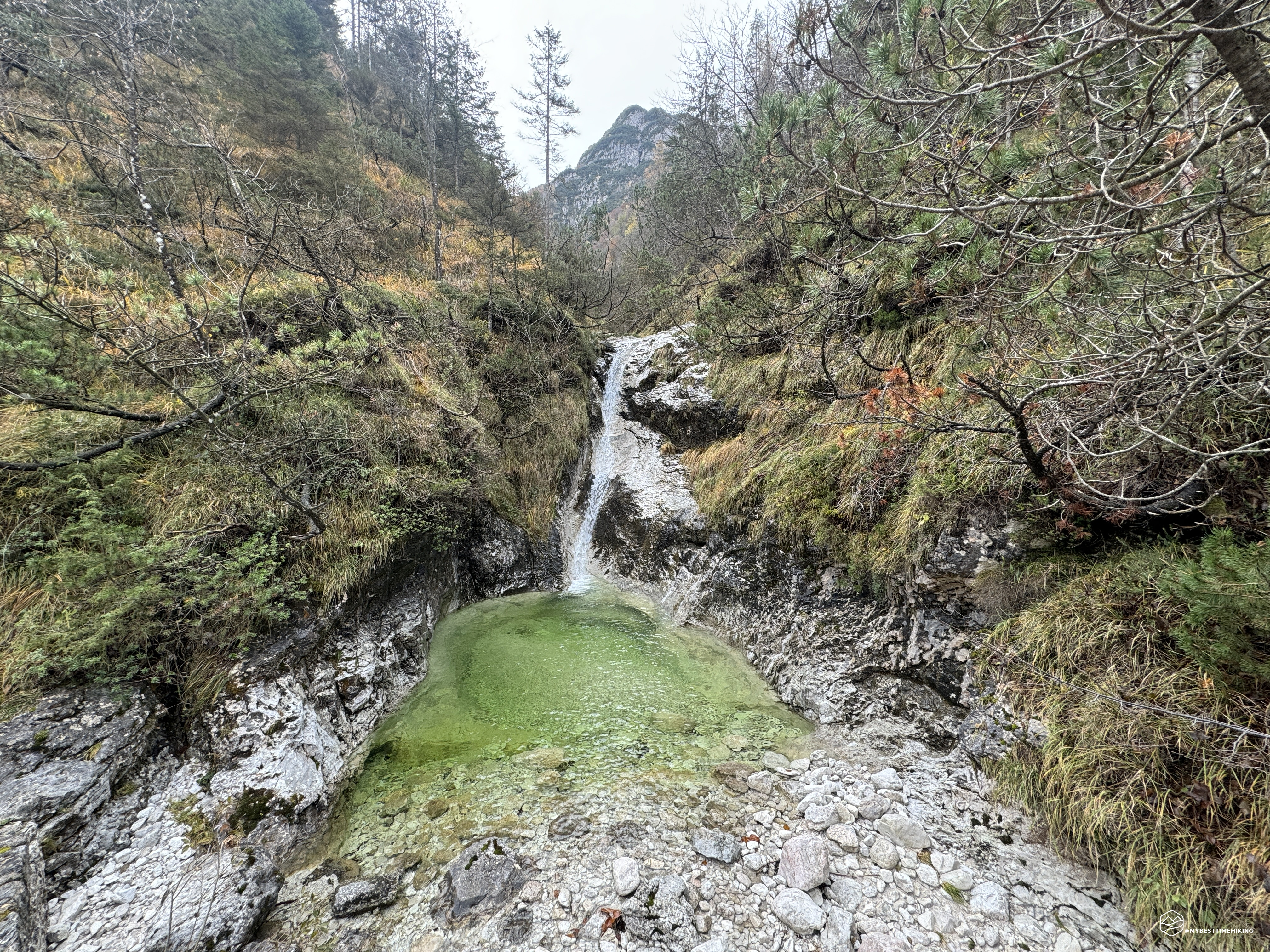
At the exit of the last tunnel we find ourselves on a lovely wooden bridge from which we can admire a wonderful waterfall that creates a basin of emerald-coloured water. On the opposite side, the same stream that comes from Val Carbonere makes a second waterfall in the direction of Cordevole. A glance that deserves a break to fully enjoy all its features! As reported by Soppelsa, the toponym Carbonère recalls the period in which these mountains were almost completely deforested to obtain the vegetal charcoal from wood which was essential for the copper manufacturing and smelting processes in the nearby mining complex of the valley Impèrina.
Immediately after the bridge there is a crossroads: the downhill route leads to the Impèrina Valley, the other uphill route is indicated for the Forcella dell'Om and the Bus de le Neole. This last place will certainly be an objective of the next spring/summer season. We follow this trail uphill with a succession of hairpin bends that quickly make us gain altitude. During the progression we cannot help but admire the changing color of the yellow-orange beech trees, the larches in the distance and the birches also in autumnal style. We reach an altitude of 1050 meters where we are welcomed by a plateau called Pianàz. The view is exceptional: you can admire the entire Agordina basin, on the left stands Agnèr, followed by the Pale di San Lucano, Mount Pezza, Palazza Alta, the snow-capped Mont'alt di Pelsa, the Framont up to Moiazza . A panorama, although contained, which still offers great emotions!
We turn around between crashed trees that interrupt the final access to Pianaz, and return to the CAI 874 path following the numerous bends backwards. At the crossroads, found shortly after the exit from the third tunnel, we take the descent route which is part of the thematic path "La Via degli Ospizi". A route of approximately 20 km which from the Certosa di Vedana, in front of Mount Peròn, reaches the mines of the Impèrina Valley via an ancient connection route between the Piave Valley and the Agordino, along which there are some hospices of medieval foundation .
We descend on a steep section and soon reach the lower edge of the mountain on board the Cordevole which accompanies us with its roar. We also pass a characteristic stream of water that creates very pretty puffs and waterfalls. We thus arrive at a crossroads, which we will encounter again later, and we proceed in a North-West direction towards the mines. We walk along a series of apparently unstable and unreliable wooden bridges. We are at the point where more than a hundred years ago there was the Ponte del Cristo (Pònt del Cristo), of which only an old iron base remains visible on the bed of the Cordevole stream. Ottone Brentari is interesting in 1887 in a section in which he describes the same route towards the mines: "At the Ponte del Cristo (built in iron in 1886) you pass again on the right of the Cordevole". While Teddy Soppelsa in 2005: “[…] built in 1886, whose remains can still be seen on the Cordévole riverbed. The bridge was blown up in 1917 by the sappers of the "Alpi Brigade".
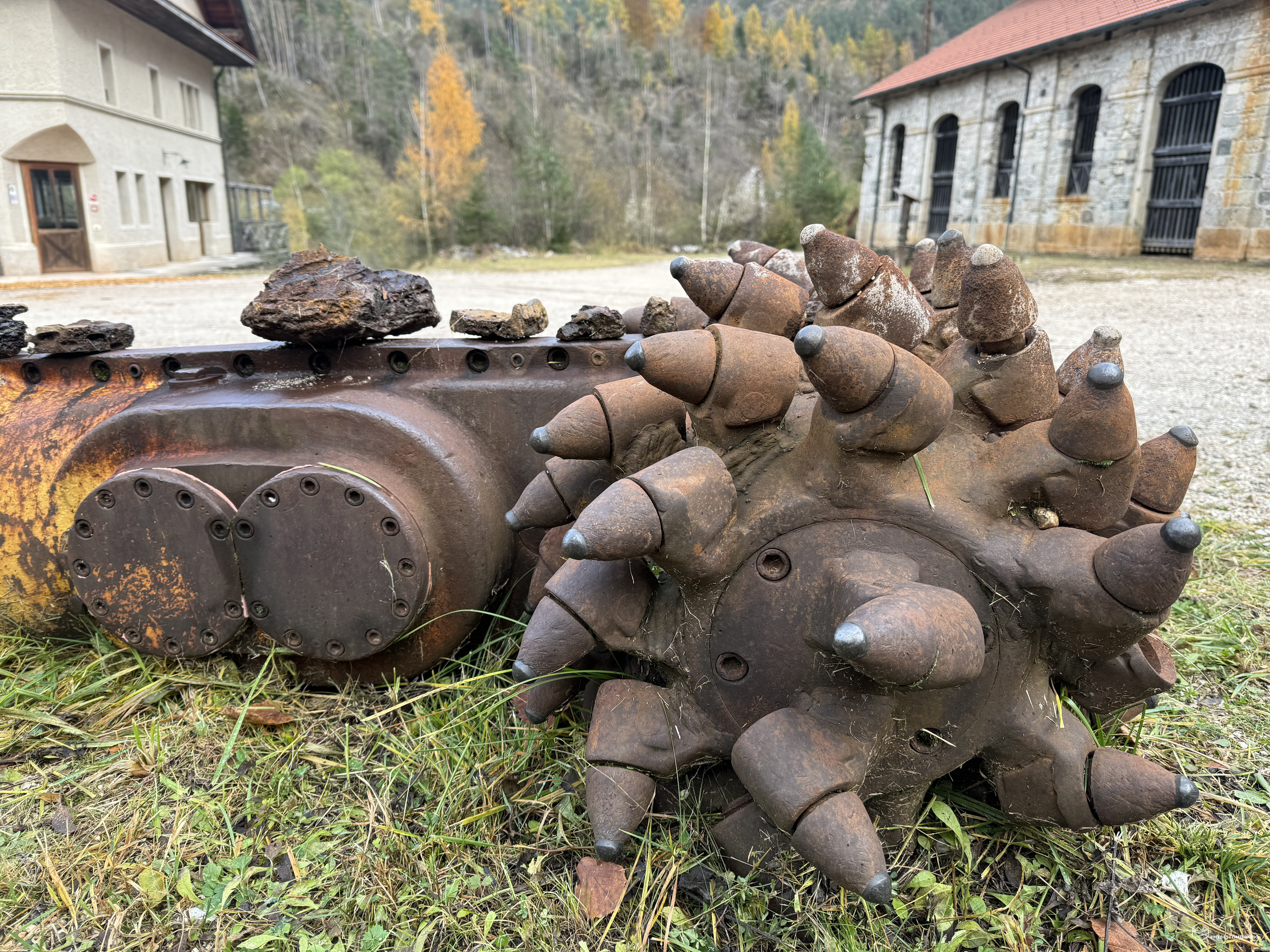
Last stretch of path halfway up the hill and we arrive at the mining village of Valle Impèrina! A place where every brick is full of history. An old hydroelectric power plant welcomes us in this exploration with an open-air museum composed of old turbines and hydraulic motors of German and Italian manufacture from the early 1900s. We follow the well-maintained path and notice old stables, former shelters for miners, the forges, until we reach the current Valle Impèrina Hostel and Restaurant, refurbished for hikers.
I report the principle of the accurate report that Ottone Brentari makes in his book. I reserve the right to share only the beginning so as not to bore you, but I am available to anyone who wishes to share the entire history of the mines present in the 1887 book: “From Agordo to Pontalto (see p. 250 in about ½ hour you go down to the Fucine delle Minere di Agordo (see p. 257); a visit that no one will fail to do if they have even a few hours available. The discovery and beginning of the mine are not known , and this is because a terrible fire destroyed the majority of Agordo with all the archives in 1635. However, note that in the famous document of 1347, with which Emperor Charles IV invested Jacopo Avoscano with the captaincy of Agordo, not the slightest mention is made of the mines, while many other things are also mentioned: indirect proof, it seems to me, that the mines did not exist at the time. They must therefore have been discovered and worked towards the end of the 14th century or the beginning of the 15th: because Catullus (On the Mines of the Venetian Alps) reports that in the Belluno statute of 1420 mention is made of this mine: and Marin Sanudo in his Itinerary (1483) talks about it with these words: «From then on one finds the Carbonare, and the fusina where one collects branches, which it was by Zuam Piero da la Torre from Treviso; and mine is then the buse, which I saw, and it was titled as follows: San Michel, Santa Barbara, San Zorzi, Santa Trinita; and I went inside, it goes past 56; and I saw a master Sboicer, German, with a long beard. Here inside these buses it is always water, and homeni cava, inside with light. This mountain, where this vein called Agort is located, is 10 m high. » From the report then sent to the doge by the podestà Francesco Soranzo we learn that the mine employed 300 men in 1529; and a document from 1559 tells of a flood that occurred in Finin before the silver-bearing veins lost from Palonia. In a writing from 1568 there is mention of another flood which caused major damage to the underground and caused the vaults of some stolli (= Gallerie, from the German Stollen) to collapse, and of continuous quarrels between those who had been invested. A proclamation dated 28 December 1568 orders that all the silver from the mine must pass to the mint of Venice to be converted into "mark" silver. [...]”.
Also interesting is a short paragraph in which the profit of this place at the end of the 19th century is described: "[...] The Agordo mine is still able to provide the Italian industry with an annual production of around 200,000 for many years kilo. of copper, 30,000 of sulphur, and 2,000,000 of green vitriol or sulphate of iron.
The sale of copper-poor pyrite to sulfuric acid manufacturers has now also begun; and if this sale takes hold, as there seems to be no doubt, 8 or 10 million kilos could be sold. of pyrite per year.
The copper rosette was sold in recent years to
L. 1.60 per kilo. and malleable copper in plates and ingots L. 1.80; sulfur per cent. 13, and the vitriol at cent. 5 per kilo.
In the mine, the horizontal or almost horizontal underground areas are called galleries or stolli. The tunnels open into other tunnels, proceed, branch out, end. Some, cut into the living rock, support themselves, others are supported by large beams and armour. Not all of them can be walked straight. In some the air is hot, breathless, in others fresh. Two or three men work at the bottom of each tunnel, illuminating the rock with an oil lamp. [...]”
Incredible how long these areas have been used for mining purposes! Changed hands from the German people, to the Lombards, to the Republic of Venice, up to the present day, where the mining activity, initially reconverted to the production of sulfuric acid, stopped all production in 1962. For over thirty years these places were left in decay more absolute until the new valorization that we enjoy today.
After having filled our eyes with so much history, we retrace our steps and retrace the same path as we went, up to the crossroads described previously. Here we proceed in a south-east direction towards Pian Castello (“Pian dei Nof”), a clearing of unkempt grass where a ruined dairy farm emerges. Even this place, which has less impact, hides a surprise: "[...] having passed the stream on a plank, continue along the mule track that crosses the Piano della Polenta. Below this, and soon N. of the rock, Edelweis are found in great quantities. This is a very rare and very remarkable thing; because these gentle alpine flowers, which as a rule are only found above 2000 m. high above the sea, here they thrive in a place that is approximately m. 520 on the sea!”.
The edelweiss! In this plateau that Brentari calls "Piano della Polenta", the edelweiss were present (or still are in season) at a truly impossible altitude.
We follow the trail that gets lost in the tall grass. However, clear stone cairns allow us to make easy progression. We enter Val Carbonere again. In front of us is the Sasso di San Martino, a monolith smooth on the sides with a bush of trees acting as its headdress. The stream that descends from the valley and flows into the Cordevole creates emerald waterfalls that accompany us to a small bridge. Here we pass on the orographic right of the stream and find ourselves in a very characteristic canyon. Rocks with reddish veins remind us that we have just left the copper mines. We climb onto a clearly visible track and soon here we are again at the San Martino fort. One exploration is missing: the top of the Sasso!
Ottone Brentari comes to our aid again: "[...] we reach the Guard House, a small fort that closes the narrow gorge between the Sasso and the mountain that rises on the right of the Serrade Valley. From here in another 5 minutes, along the path that first turns to the W. side and then to the N. of the hill, you reach the summit of Sasso di S. Martino, large rounded cliff that closes the valley. From up there towards the N.W. you can see the plains of Noach and a good part of the road towards Agordo, Agnèr and Pale di S. Lucano, and towards the S.E. the mountains towards Belluno, including the Gusella di Vescova. The ruins of the chapel of S. Martino still exist."
It seems impossible, but by following these instructions to the letter we found the path, still passable, almost easy, except for a few fallen trees. We go up, we are close and... here is the top! It leaves us with a bitter taste in our mouth since the summit is practically a single pile of crashed trees. We are looking for the remains of the church but they have evidently been swallowed up by vegetation. When we are about to lose hope, a couple of rocks stacked in a linear and orderly way make us jump: yes, it could just be a part of the wall of the old 15th century church that stood alone here!
We are satisfied with the rediscovery, we return to the fort happy with this adventure. We just have to go down but the "Tunnels" sign that we notice at the entrance to the descent path leaves us perplexed: where are these other tunnels? We've pretty much explored everything around here and haven't seen them. We follow this, initially thin and then very wide, track and we notice another new tunnel. We carry out this last adventure in the company of the frontal one and discover a maze of variations that lead upwards: shall we return to the top of the Sasso di San Martino? We beat them inch by inch and on the steepest route we see a tunnel hole that seems not yet finished. In fact, we struggle out of the tunnel and practically emerge on the top of the Sasso, surrounded by other crashed trees. We dive back into the tunnel that is not particularly easy at this point and exit through another variant further down. We find the external path again and follow it backwards until we rejoin the fort and the descent route. Once back at the roadman's house, we quickly return to the car, remembering to turn around and admire Agnèr in the distance, which is taking on the colors of the sunset.
Thus ends this truly surprising adventure which gave us anecdotes and singularities at every step. The view was the protagonist as in all excursions, but here today there was much more. A set of stages that left us speechless among myths, history and mountains with autumn colours. An excursion that was not excessively long and tiring and gave us truly evocative emotions. However, it is suitable for expert hikers due to the difficulty of orientation in some points (especially the more exploratory ones), an alternative to the more famous streets of the Agordino area.
DifficultyExpert hikers - are generally signposted itineraries but with some difficulties: the terrain can consist of slippery slopes of grass, mixed rocks and grass, stony ground, slight snowy slopes or even single easy-to-climb rocky passages (use of hands in some places) . Although they are routes that do not require particular equipment, equipped sections can be presented even if they are not demanding. They require a good knowledge of the alpine environment, a safe step and the absence of vertigo. Physical preparation must be adequate for a fairly continuous day of walking. |