New adventure in the Agordino together with the legendary Enrico. Today we retrace the footsteps of the first hiker to reach the top of Sasso Bianco: the English explorer of the late 19th century, Amelia Edwards.
We reach the village of the Pecol fraction of the municipality of San Tomaso Agordino early in the morning. The road is paved but quite narrow. Fortunately, a large parking lot has been created where there is a trail sign indicating "Rifugio Sasso Bianco". Should there be no space in this new clearing, there are some seats on the roadside. The day is immediately hot with a sun that has no intention of giving a break. We prepare to perfection, backpack on our shoulders and start the wide road that lies ahead.
The cart track is very wide, dug between the porphyry rocks and the wood of Monte di Sotto. The road does not match the track shown on the Tobacco map. Compared to what is reported in the cartography, the road is decidedly easier and with a gentler slope. Most likely this new access road was created specifically to quickly access the forest after the disastrous Vaia storm. On the sides of the path, in fact, we notice several crashed trees next to numerous trunks properly sawn and ready for transport.
We begin to see the first old barns, the wooden tabià, and at an altitude of about 1400 meters the road continues inside the wood, but a sign with a path on the left notifies us of the change of direction to reach the refuge. We thus enter the undergrowth, in any case not so fresh. The terrain varies almost immediately from earthy with outcropping roots to rough asphalt optimized for the winter season. Even if it doesn't seem like it, given the difference in width with the wide road just left, this track is used by the jeeps of the residents who have tabià right here. The paved path takes a decisive inclination and allows you to gain a lot of altitude in a few hundred meters. Wooden barns are starting to be more frequent and even the types are distinguished between old wood with worms and tabià refurbished complete with nameplates.
At the end of the paved climb, the path becomes stony again and soon takes us to a panoramic opening towards the Pale di San Lucano. We are on the "Costa delle Palote" where the driveway actually ends and there is the cableway used by the refuge to receive the heaviest objects in comfort. Here begins a path finally worthy of its name among green meadows always welcomed by the surrounding wood. A small wooden bridge heralds a special climb that runs alongside a luxuriant and bubbling stream. Rocky leaps create playful waterfalls and the track develops on the edge of these wonders. Pay attention in this part of the path due to the presence of wet rocks which may not always guarantee sure footing.
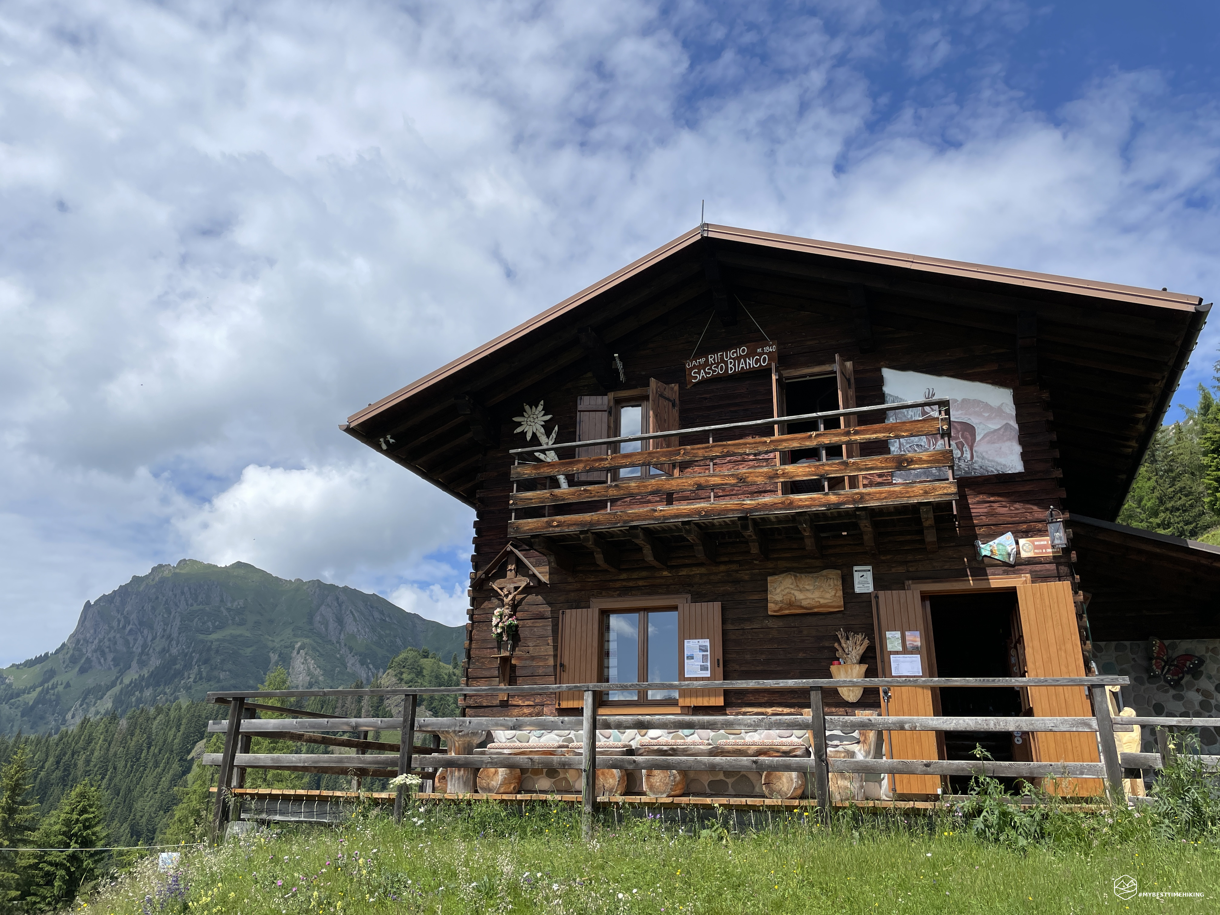
We are now at an altitude of about 1700 metres, we climb steeply in this particular section which opens up from the shade of the wood with the first aerial panoramas of the surrounding peaks. We are above the rocky crag of Monte di Sopra. We reach the last uphill section with the "Colfosch" trail sign (1790 metres) and the slope almost disappears. A comfortable and relaxing lawn introduces us to a plateau dotted with a myriad of wooden houses. It seems to have gone back in time: children playing ball, clubs cutting the grass, the scent of hay, the scent of fields in bloom. In the background towers a wooden house bigger than the others: we have arrived at the Sasso Bianco refuge!
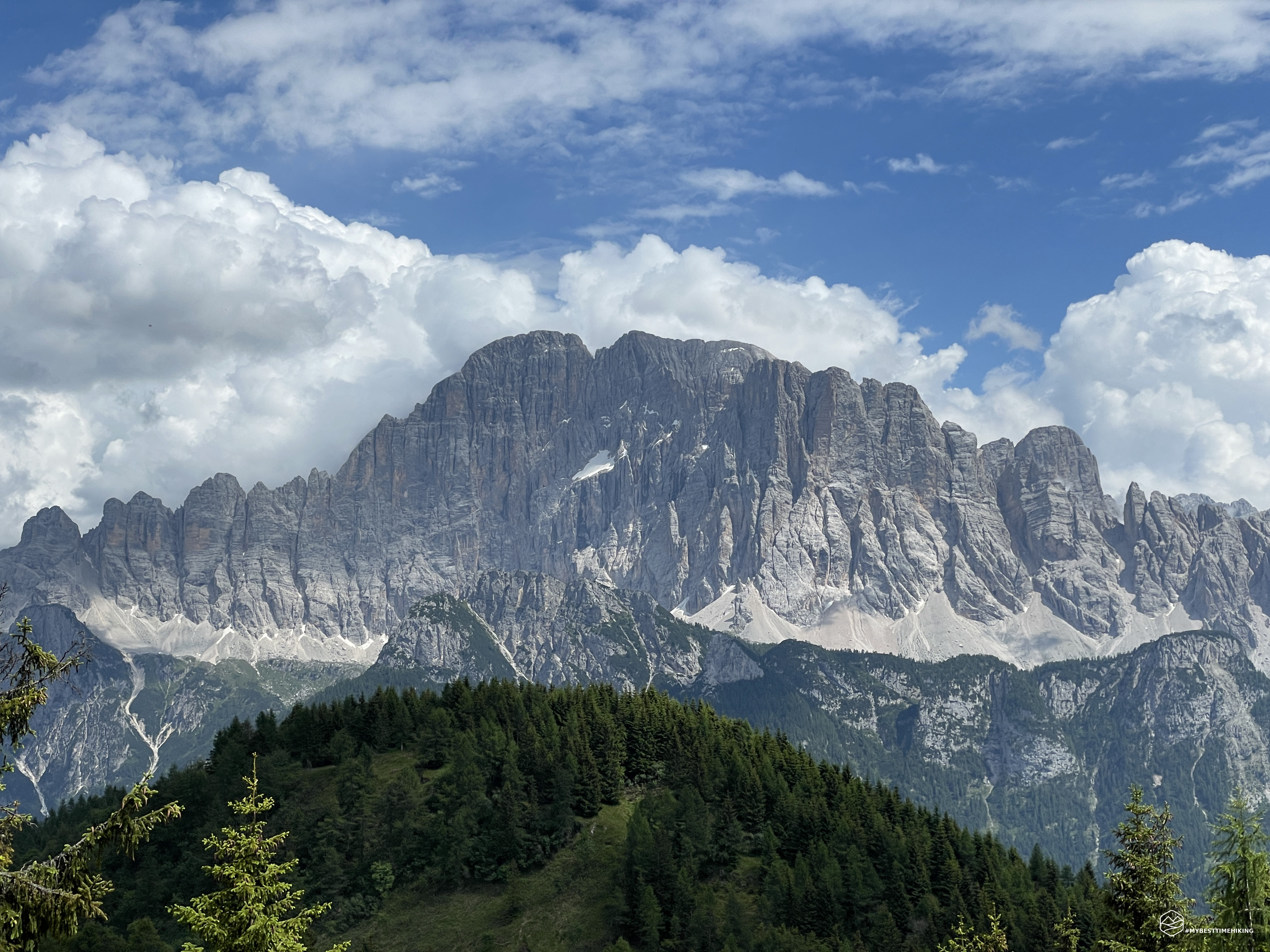
The refuge dominates this grassy expanse, as we turn around to admire the panorama behind us we jump: the unmistakable wall of the Civetta is in front of us, majestic, without interruptions, it seems we can touch it! We allow ourselves a small break and look at the remaining route to the top on the large map printed next to the refuge. Thus we continue on the only path of the day, the CAI 623 track, immediately gaining some altitude by first entering a short wooded stretch, and then exiting on an expanse of tall grass (with a view of the Civetta). In a few minutes we reach the saddle from which we continue westward climbing the ridge. Various vertical signs invite you to go east towards Pecol-Piaia, while to the north towards the meadows of Giardògn. It was from this place that the explorer Amelia Edwards ascended during her ascent at the end of the 19th century. From here we imagine that we are rejoining her journey: she is still on horseback, while we are still on foot.
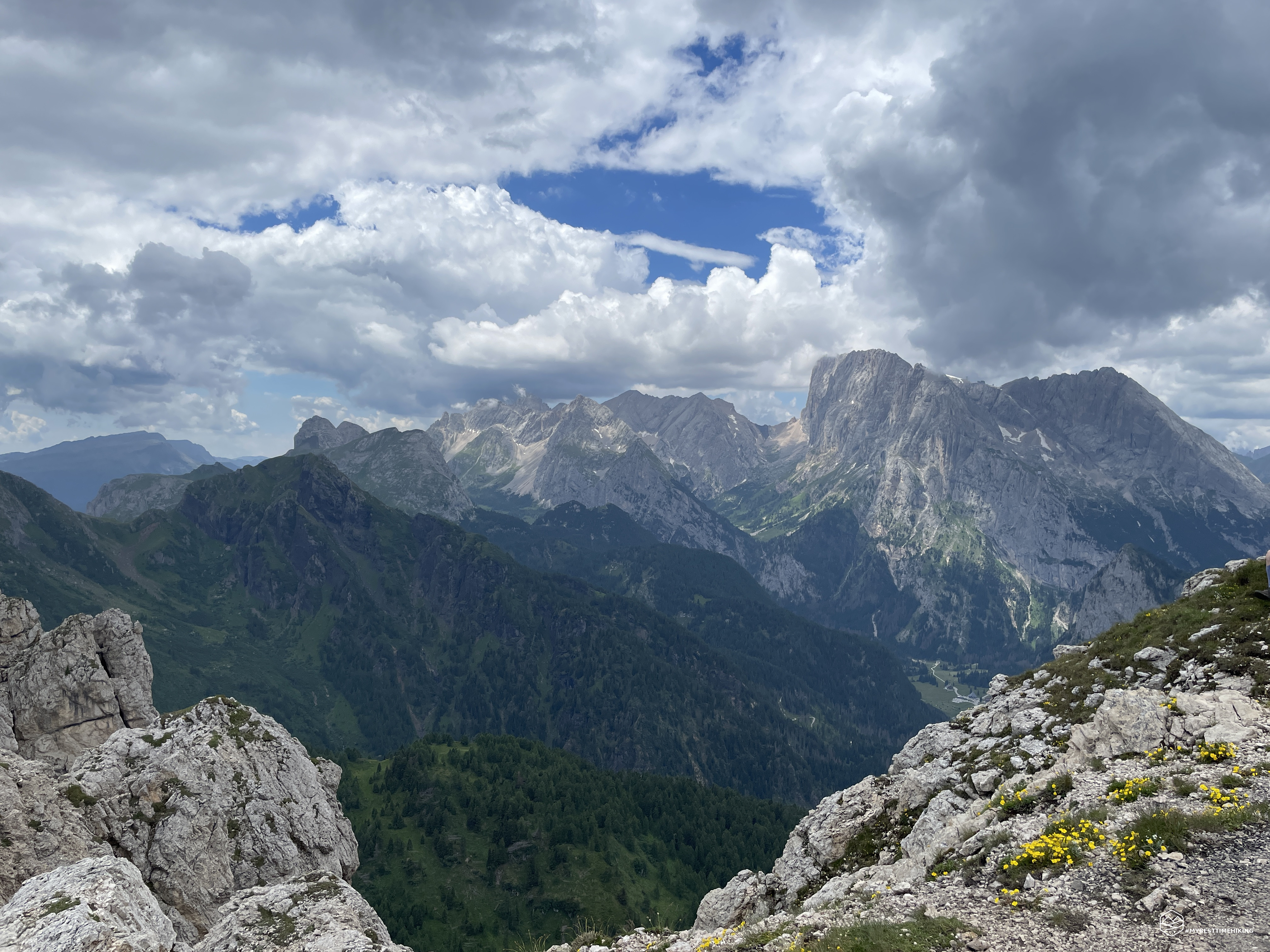
The ridge climbs steadily, occasionally opening up to incredible views towards Col di Lana, Val Badia and the Tofane. We proceed in a North-West direction towards the Sasso Nero, an old volcanic cap. We soon arrive right near the apex of the cap, we pass a short collapsed section and go around the top of Sasso Nero. We thus arrive on a gentle slight slope that allows us to observe a rocky barrier that appears bold. In the book "Unviolated Peaks and Unknown Valleys", Amelia Edwards described this point thus: ”The climb isn't easy and we, improvised climbers, don't face it in the best conditions. We use the unevenness of the terrain and the small cracks as natural steps, but they are so steep and jutting out that they remind us of the rough and worn steps of the Great Pyramid. And if it weren't for Giuseppe, who climbs up in front of us to offer us help if necessary with the power of a winch, the writer would not have overcome the last barrier first. Along this stretch, short but inflexible, we expect to glimpse a profile, a sign indicating the summit, but it remains stubbornly invisible and it seems to us that we are moving away from it irremediably."
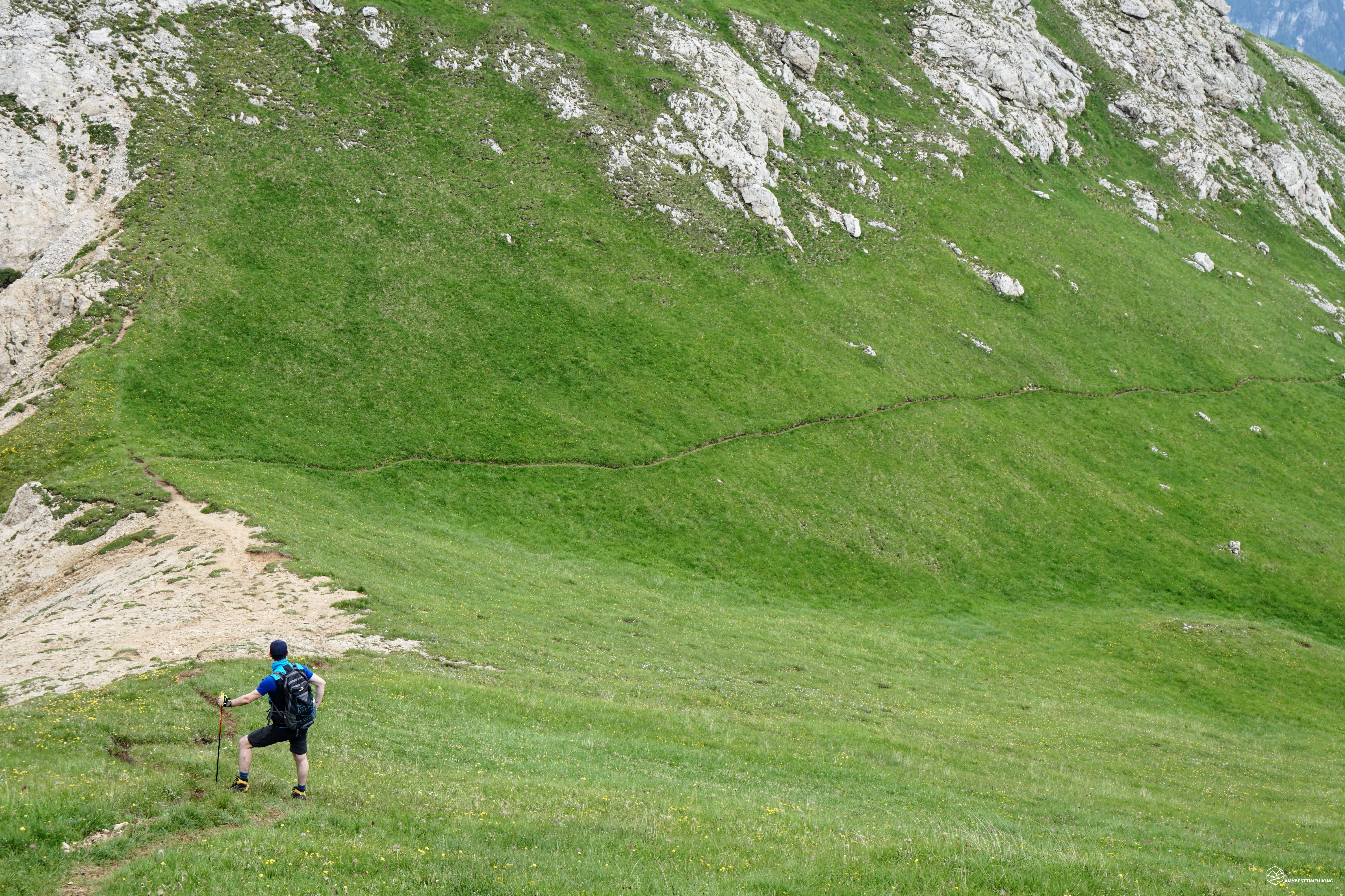
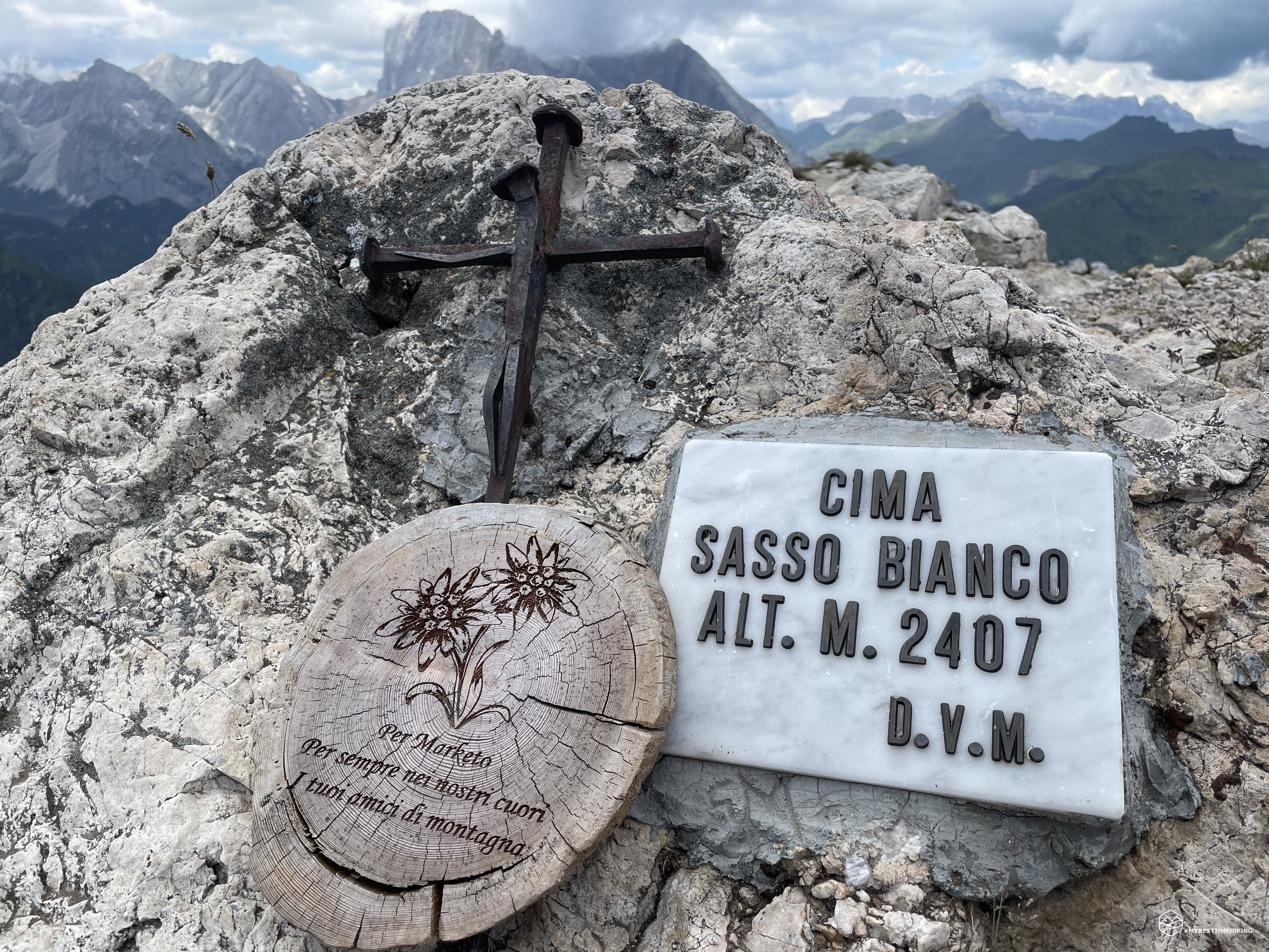
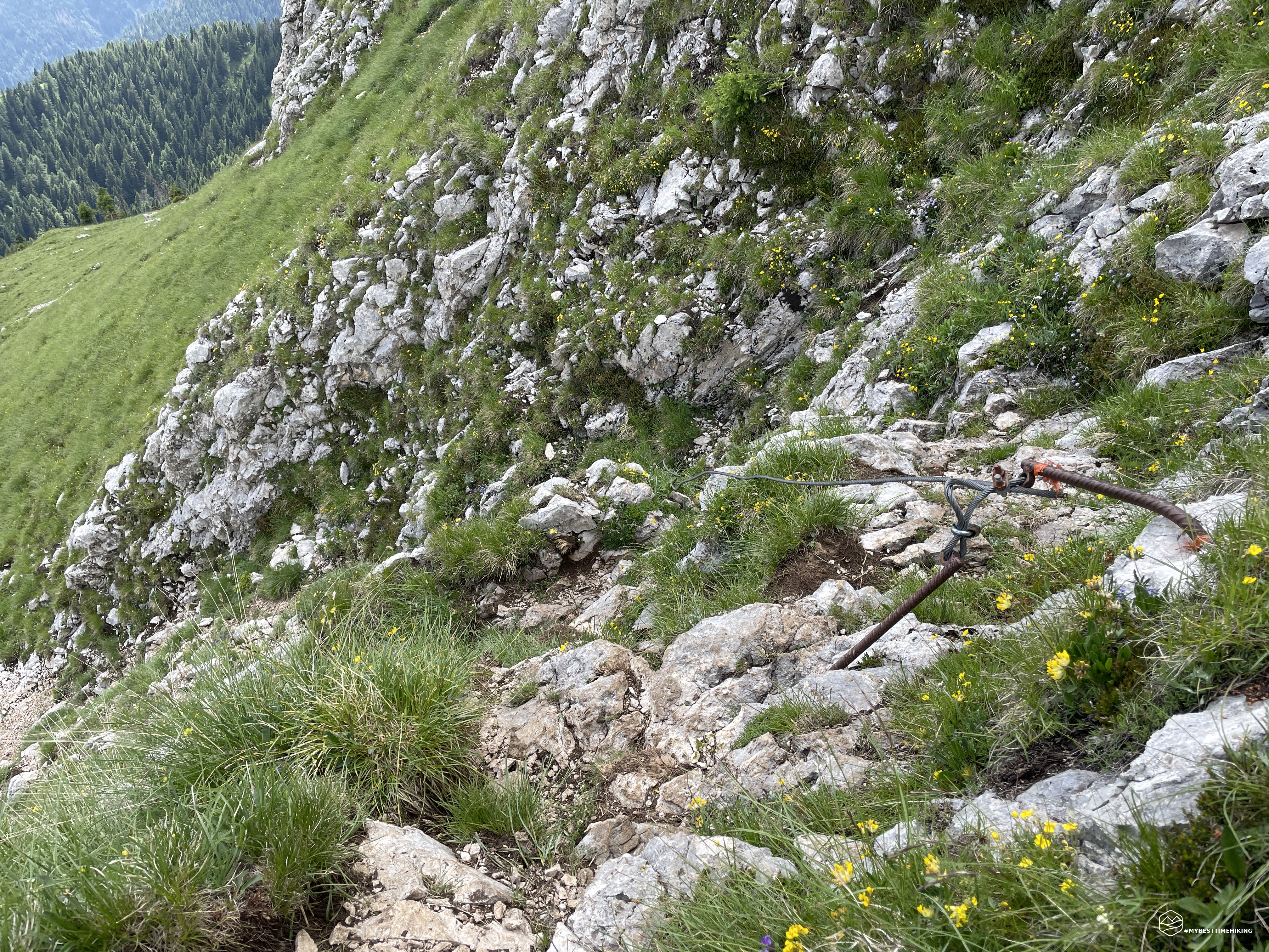
Amelia is right about the brevity of the stretch and the impossibility of still seeing the coveted peak, but now the track is clearly evident. There is also a metal cable that should provide more security. Unfortunately to date, in the absence of maintenance, it appears more dangerous than useful for the purpose. We carefully pass the rocky ledge and find ourselves in a verdant basin with a clear indication "Cima Sasso Bianco". A little further on we first find the indication for the foresummit "Cima Plan", then a large boulder with red paint and relative arrow identify our half of the day. The path proceeds in a different direction than indicated by the arrow on the boulder. I recommend following the arrow. Proceed thus on a grassy ridge, very comfortable, where a timid path is visible. We proceed with a steep but never too tiring slope.
Date
08-07-2023
Distance
15.58 KM
Hike type
Hike
Ascent
1305 mt
- Mountain
Sasso Bianco
- Address
San Tomaso Agordino, Veneto, Italy
- Altitude
2407.00 m
- Refuges
Rifugio Sasso Bianco
- Information
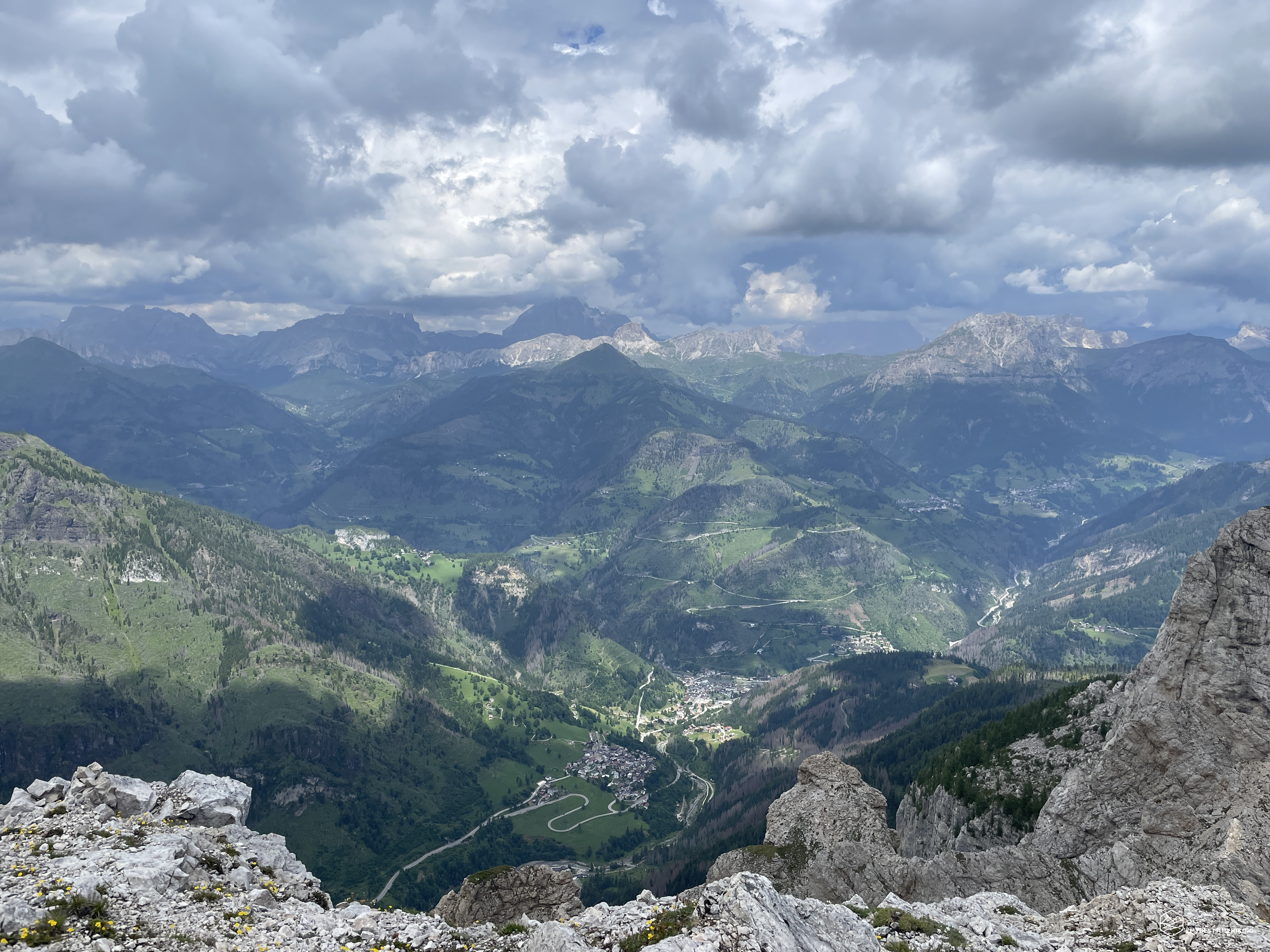
They gain altitude and in less than half an hour we arrive close to the foresummit. In a westerly direction you can clearly see the path that approaches the ridge that connects the summit and foresummit. From here we can see the tip of Sasso Bianco, just a few steps away! We go down a few tens of meters between the meadows to reach the junction saddle between the peaks. Now let's take the official path and proceed quickly towards the summit. We see the basin towards Sasso Nero, the aerial view begins to be unchallenged, the wind whips and finally refreshes us for the first time in the day. The thin earthy stretch allows you to climb the last few meters giving us overhanging windows towards Rocca Pietore. Last steps, turn north, and here we are: top of Sasso Bianco! 2407 meters above sea level, on the pyramidal cusp of Dolomia of the Monte Pezza group. A peak that stands out in the center of the whole of the Dolomites between the Agordino, the Zoldano, the Ampezzo up to Val Badia and the Austrian peaks! After just over three hours from Pecol, here we are at the top with a breathtaking view!
Here it is obligatory to report the testimony of the first conqueror's arrival at the summit, together with her companion in adventures and the two local porters, with a laughable curtain: "It was already half past eleven: having not touched food since five and having climbed four or five thousand feet since that first breakfast, we felt, and rightly so, really hungry. Thus, before verifying the altitude, identifying the peaks and the relative distances, we busied ourselves busily with the lunch basket and we certainly found the usual meal of hard-boiled eggs and bread no less tasty. The water in the flask was hot, but the ingenious Clementi mixed it with a large block of snow melted in the sun and with a little brandy, thus obtaining a fresh and delicious drink. While we were indulging in that frugal feast, Clementi, with the keen eyesight of a chamois hunter, recognized "L." (which he calls the "Lady Waitress") on the Cordevole bridge, just outside the village. We were able to distinguish only a black dot, no bigger than the head of a pin, but Clementi didn't miss even the tiny spot on the parasol. The two men were immediately on their feet, tied a handkerchief to a white umbrella and tied this to one of our alpenstocks, they waved it vigorously as a signal. The excitement that accompanied this attempt lasted a full quarter of an hour during which the tiny black spot remained motionless on the deck and only calmed down when it slowly dissolved in the direction of Caprile.”
The panorama is 360 degrees, starting from the Civetta moving west you can observe Mont Alt de Pelsa, behind the Moiazza, you can see the whole Agordina Valley perfectly, with the Pale di San Lucano, the Cima Pape, from behind the unmistakable Agnèr appears. Continue to the Pale di San Martino di Castrozza, the Vezzana peak, up to Sass Vernel, the Ombreta peak and the majestic Marmolada. The ring ends passing the Sella group with the Piz Boè, the Col di Lana, the Sass de la Crusc and the Piz de Lavarela of Val Badia, the Lagazuoi, the Tofane d'Ampezzo, the Becco di Mezzodì, the Sorapiss up to the overcast Pelmo! I want to repeat Amelia Edwards' description of the Marmolada (which at the time they identified as "Marmolata") and the Civetta: "At a distance of only two miles as the crow flies, the Marmolata and the Civetta rise in all their grandeur. The latter fills the entire view towards the southeast, up to the horizon line: huge masses of fog still float along the immense wall whose tops plunge into the blue depths of the sky. The Marmolata outlines itself with a bold and clear profile, not veiled even by a wist of fog. Mr. Gilbert, when from Sasso di Dam, therefore from the west, found himself observing the profile of this mountain, he compared it to an enormous pen holder with the vertical side facing south and the long snowy ridge facing north. But from our angle of perspective, towards the east, we can clearly distinguish the deep chasm that divides its high peaks and makes the mountain absurdly resemble the familiar felucca of the first Napoleon: the perpendicular wall is naturally the front brim of the well-known hat and the snowy slope corresponds to the rear part. A wide river of snow lies in the deep bed of the gully and the north side is a completely silver line, while the great snowy expanses and glaciers of the slope facing the Fedaia Pass remain invisible from this point.”
We enjoy these beauties, we finally allow ourselves a nice restorative break and we also observe the sun-kissed valleys below. The village of Rocca Pietore is the most characteristic and continuing with our gaze towards Ronch we notice the monoliths which from here look like simple Saxons without art or part (discover the adventure at Sass da Ronch). We get back on our feet and begin the descent along the same route as the outward journey.
At the fork between the two peaks we choose to follow the marked trail proceeding along the obvious cattle track that cuts the grassy surface like a blade. We return shortly to the detour with the indication on the large boulder seen previously. We proceed in the direction of the rocky crag to be covered carefully, then on the meadows of Sasso Nero and finally to the Sasso Bianco refuge. Here a nice cold beer makes us relax in front of the view of the Civetta today completely clear of clouds. The descent from here to Pecol is rapid, almost running, the legs now go by themselves. The further we go down, the more the heat oppresses us and immediately sends us back to the pleasant coolness found at the summit. We reach the car and congratulate each other again for the wonderful excursion we have experienced!
A fairly long adventure, for hikers who are definitely trained to bear the more than 1000 meters in altitude to get to the top of Sasso Bianco. However, it is possible to arrive at the refuge and enjoy a splendid day immersed in nature with a panorama that is second to none. The summit, on the other hand, offers certainly unique emotions that repay the effort. I close this report with a final consideration by Amelia Edwards, the absolute protagonist and proponent of this adventure who had an immeasurable love for this mountain that she was the first to conquer. Her vision fits perfectly with our excursion today: ”We could have chosen, as I said, a nicer day. We could have... seen Venice and the Adriatic if chains of little importance hadn't come between them; perhaps Lake Garda to the southeast; and maybe the Ortles, if it didn't rise right in front of it Marmolada. Joking aside, the panorama to the north and north-west was wonderful and the view of the surrounding Dolomites extremely interesting. I think I'm right in doubting that there are other points from which it is possible to admire all the giants of the area just as happily and with the same satisfaction."
DifficultyExpert hikers - are generally signposted itineraries but with some difficulties: the terrain can consist of slippery slopes of grass, mixed rocks and grass, stony ground, slight snowy slopes or even single easy-to-climb rocky passages (use of hands in some places) . Although they are routes that do not require particular equipment, equipped sections can be presented even if they are not demanding. They require a good knowledge of the alpine environment, a safe step and the absence of vertigo. Physical preparation must be adequate for a fairly continuous day of walking. |