

New exploration adventure in a magical place to which I return after more than 20 years: the Cadini di Misurina! It is a place of the heart for me, constantly reached every year when I reached Cadore for my teenage summer holidays. I therefore have a truly felt desire to follow these paths and, by inclination of MyBestTimeHiking, to add some unexplored destination that gives an adventurous and interesting sense to the excursion.
I reach Misurina, where you can find roadside parking just before the Pio XII Institute. The air is crisp, 10 degrees are felt, the day promises to be perfect: the last impalpable clouds are leaving the peaks of the Tre Cime di Lavaredo and the blue of the sky is becoming more and more decisive. Laced boots, backpack and let the adventure begin!
I walk along the roadside admiring the grazing cows and horses that keep company with their cowbells. As soon as you pass the Instituo Pio XII, turn right towards the departure of the Colde Varda cable car. Today I give up any external help and proceed along the CAI 120a path which, thanks to a very wide path, allows you to gain the difference in height necessary to get to the Col de Varda refuge. For those who want to "cut" the main road, you can walk through clearings with a nice steep slope that look like winter ski slopes (and perhaps they are too). Within half an hour I reach the crossroads that on one side leads to the Col de Varda refuge and on the other continues towards the Città di Carpi refuge.
I choose the second option and thus walk a path and no longer a dirt road. In a few steps from the crossroads you arrive at a beautiful panoramic point on the Sorapiss with a view towards the Averau, the Nuvolau and the Tofane nell'Ampezzano. The track continues flat, at times slightly losing altitude. It is a really pleasant walk and suitable for everyone: there are no important climbs, the route alternates with pieces in which the side towards the S is open with low pines that allow you to enjoy a magnificent panorama, at other times it creeps into vegetation that refreshes without ever being overwhelming. On the N-NE side it is already possible to see the first peaks of Cadini: the peaks of Maraia. After passing the grave de Pogofa and the Bus de Pogofa, the path begins to rise again gently and opens up in front of a grassy ridge called Col del Viero. From here it is already possible to see the flags that rise above the refuge, while on the other side the dark green of the forest and the light green of the grass form the basis for the spectacular Sorapiss, from which you can even glimpse the sparkle of Lake Vandelli .
In front, however, a stony massif called the Croda de Cianpoduro. Just a few steps away from the Maraia fork from which you can finally admire the Città di Carpi refuge in its full figure. From this position, moreover, you can also observe the beautiful peaks of the Croda dei Toni. A small refreshment break in front of a comfortable wooden sign where all the different options to reach the Fonda Savio refuge are marked. My choice falls on the second option: 116 F. Verzi Nevaio h 3. From the Tabacco map the path 116 is only the one that goes to Cianpoduro while the one I take in the direction of Cadini is 118.
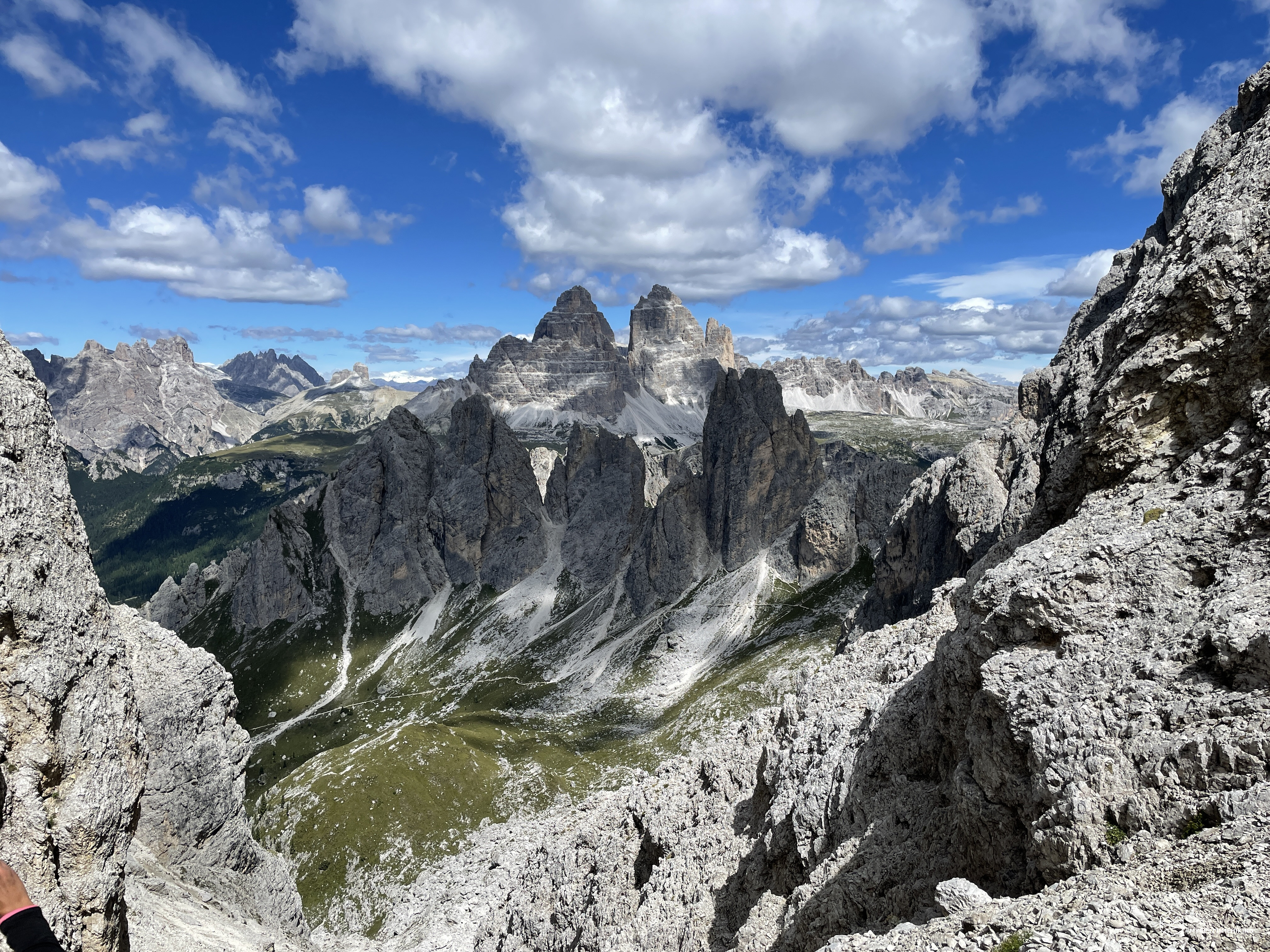
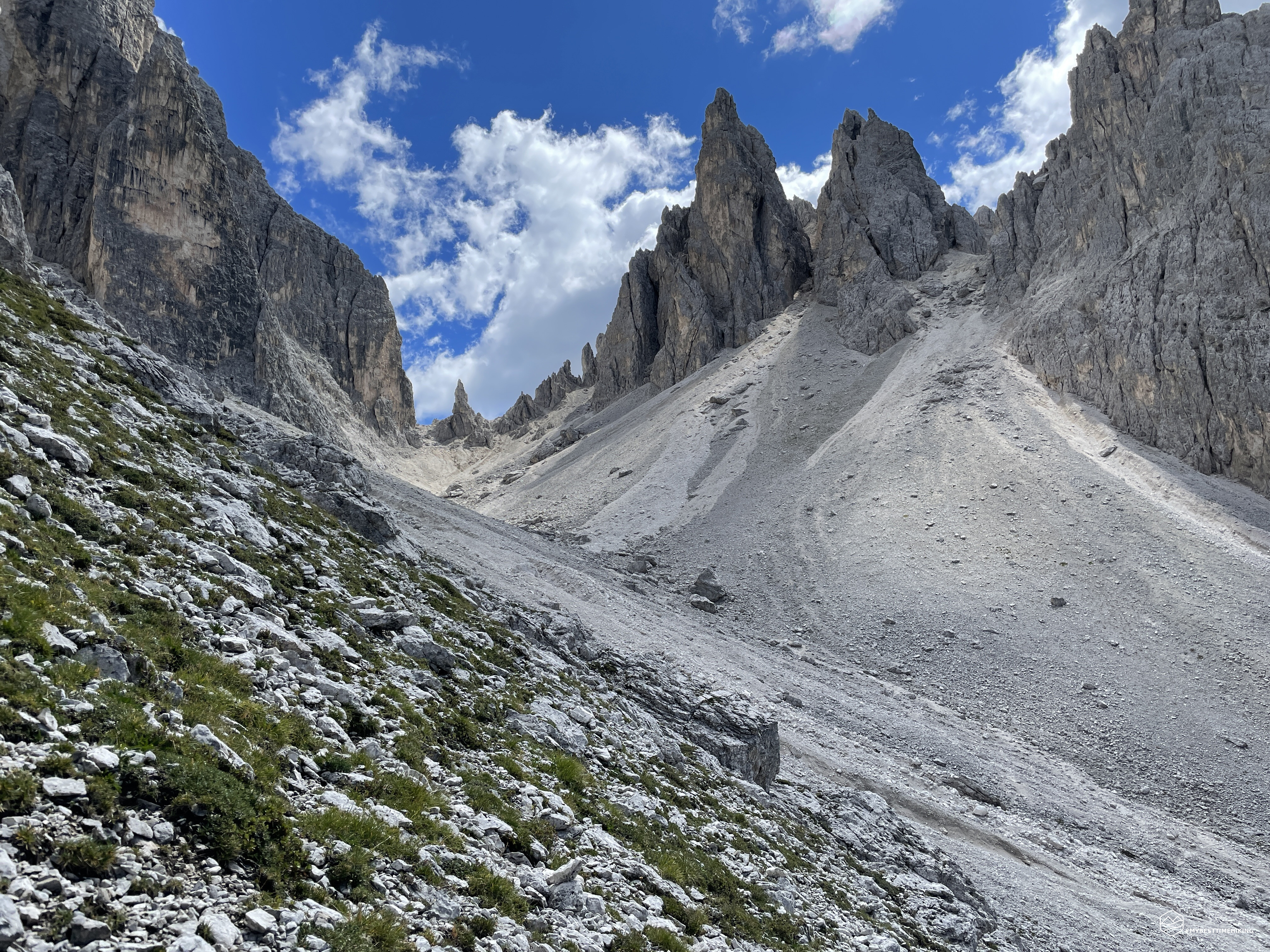
I walk along the Pian de la mussa, a false floor that climbs up a narrow and earthy path in the direction of the first cadin of the day. Climbed over the grassy plain you come out on another plateau with a stony weight from which the road becomes more bristling on narrow furrows generated by landslides. It is possible to walk the path on soft grassy steps on the left and arrive at a fork-like that offers a splendid view of the Cadin de le Pere and in the background the Cadini di Misurina in all their splendor. From here we begin to distinguish the forks of the Snow and the highest Verzi fork, the spiers and the many sharp points that form the peaks of Cadin della Neve, the Cadin di San Lucano peak and the NE (North East) peak with the Merlone via ferrata. .
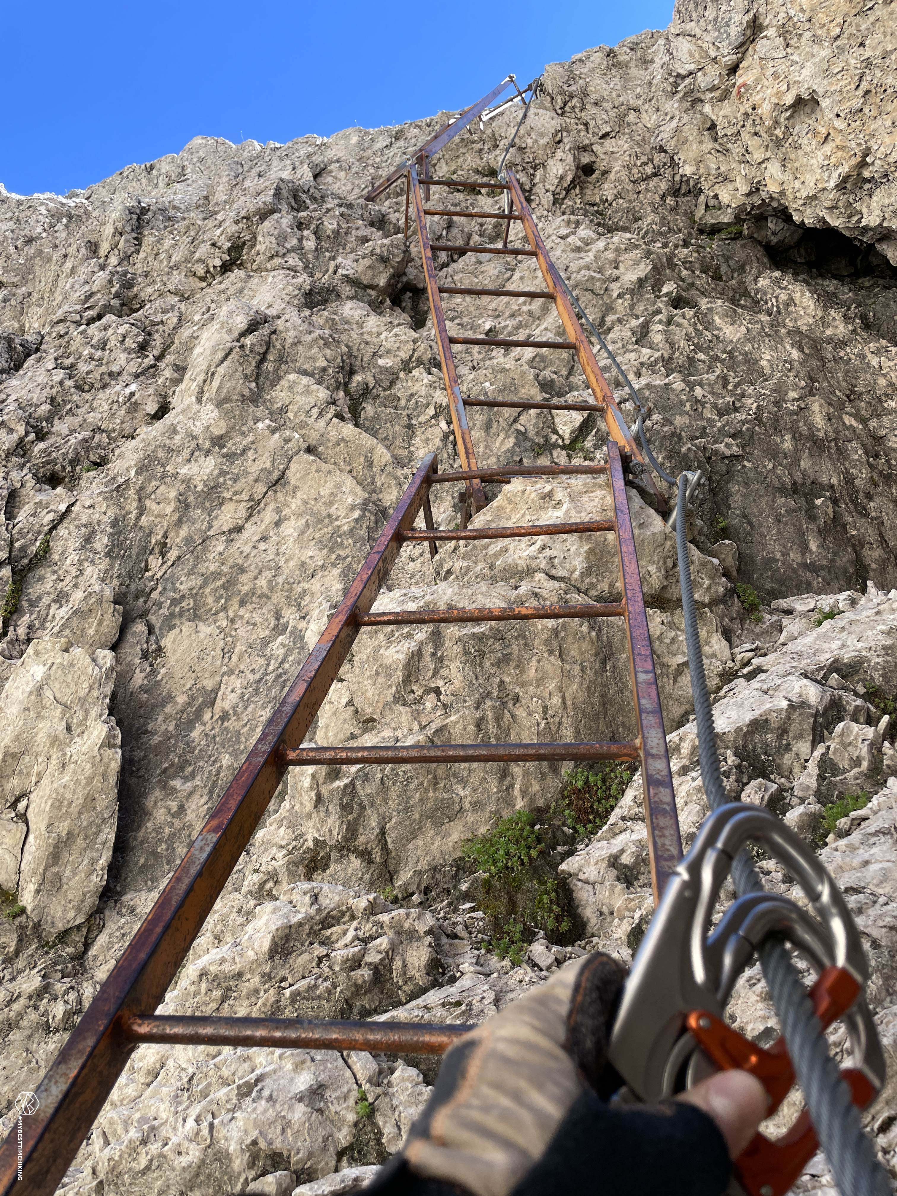
I continue on a stony path until I reach a basin with large boulders stacked one on top of the other. I find the indication of the fork between the fork of the Snow on my left clearly visible and the fork Verzi on the right wedged between the rocks that stand out to cover the final destination. The indication with CAI signs is present on the left pointing first to the fork of the Snow. Choosing to stay on the right and "cut" a few meters of path, you have to be very careful of the red marks on the rocks of the grava. From the stony basin, go up towards the E on a clearly visible track, where there are boulders with evident red arrows that indicate the folding towards the West first and, a little further on, towards the NW with very clear indication on the rock with the inscription "Forcella Verzi" and the arrow towards left. The red dots are constantly present and in the presence of one the next sign is easily distinguishable by following the path traced correctly. After a few steps the aided section starts immediately: metal cord and iron ladders allow you to overcome jumps of rock of a few tens of meters with ease and safety. The via ferrata kit is recommended to travel the route in peace. The route always juggles inside the gully that leads to the saddle. Sometimes tight and bristling, it is interspersed with stretched sections where there is no insurance cord. Some ladders seem "dancers" and some attacks on the rocks of the same show the wear of time. In some places the metal cord is loose. Maintenance should be carried out on the whole aided section which, in any case, always transmits safety of progression and solidity in the most exposed and vertical sections of the gully. At an altitude of about 2500, from the right orographic side where most of the ascent takes place (left side going up), you cross the gully without insurance. Pay attention and steady step. On the other side the via ferrata starts again in a stony corridor. A series of three steps in succession earns the last piece of elevation gain. One last crossing of the gully, last steps and here you have reached the Verzi fork! 2550mt (my GPS marks 2575mt even after calibration), turning around you have a splendid glimpse of the climb just completed and a beautiful window on the Marmarole almost arranged in a row. On the other side the view, towards the north, is closed by a rocky mass that invites you to the next destination: the Forcella del Nevaio.
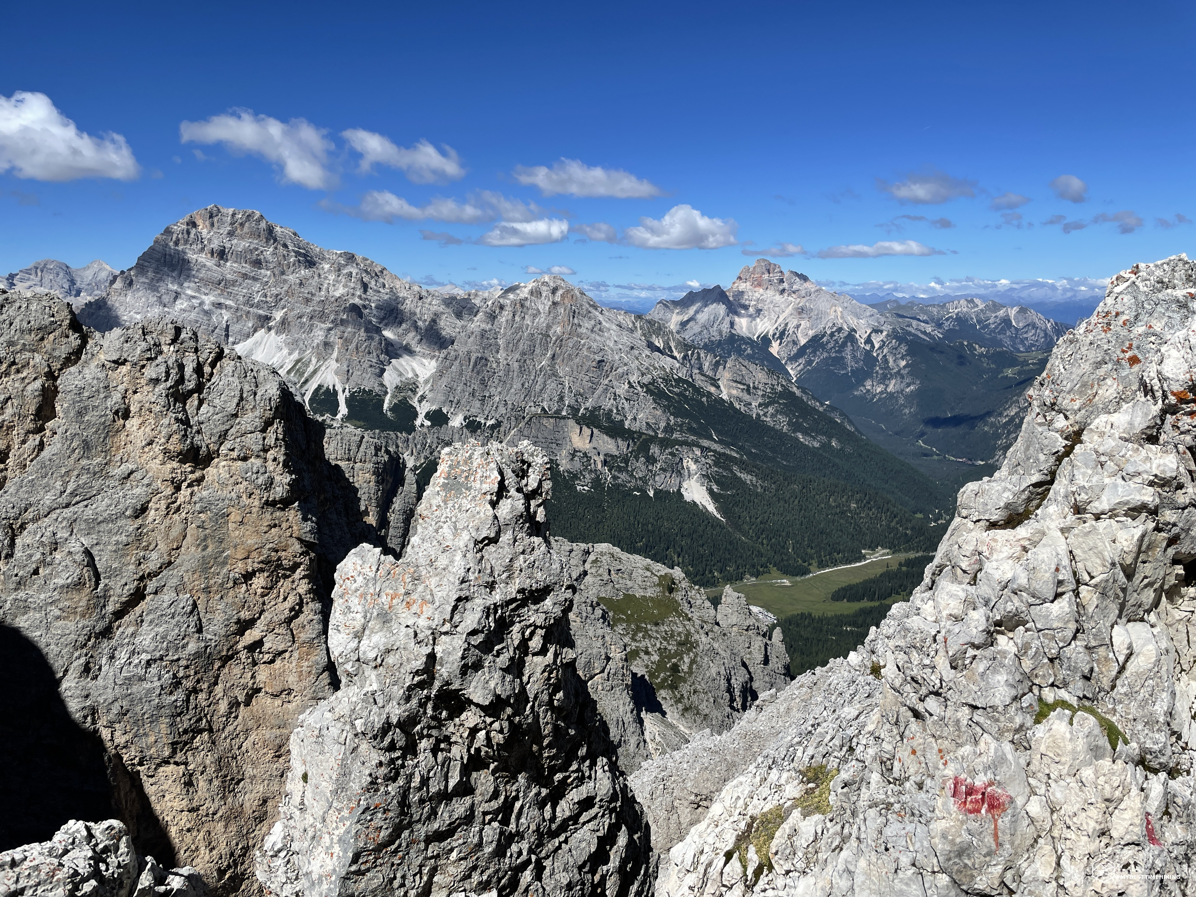
The path resumes climbing to the right with an attached metal cord. The climb is pleasant, the lanyard is just greater safety for a route that is in any case comfortable and without danger of any exposure. The stretch is short, pleasant with progression on some points where you have to use your hands to hold on and climb in climbing style. In a few minutes you arrive at a small gravel climb where very comfortable steps have been installed created by wooden planks in opposition to the slope. Fast and agile climb up to the crest in the fork: here is the Nevaio fork at 2645mt (officially 2620mt). The view from up here is truly spectacular: from the left you can see the sharp towers of the Cadini di Misurina and, in the various openings that they form, you can admire the Cristallo group, the Croda Rossa d'Ampezzo, Mount Piana, up to the characteristic Tre Peaks of Lavaredo. Towards the S you can see the thin Verzi fork entangled between the rocks, the Marmarole and the Sorapiss in the background. From up here it is already possible to glimpse the Cadin de la Neve (or Ciadin de la Neve) and the Cadin del Nevaio (or Ciadin del Nevaio), to be reached after a descent that seems pretty difficult.
In fact it is like this: the descent route is very steep on hard and very compact gravel. Fortunately, the usual metal cord comes in handy, allowing a safe and very pleasant descent. In the first section you go along a rocky tongue which, with a succession of short and continuous changes of direction, allows you to quickly descend and reach the bottom of the sweet scree with comfortable soft gravel. As previously said this is called Ciadin del Nevaio, here in fact, even in summer, the presence of an accumulation of snow in the upper part of the cadino has always been recorded. This year, unfortunately, there is a single dark gray spot, small, almost imperceptible, at the lower end of the scree. A bleak spectacle that in some ways makes you shiver. In some points of the descent, once the rocky tongue is finished, the route moves to the left orographic side leaning against the mountain. Here it is clearly visible how the metal cable is almost difficult to reach because it is too high! In fact, usually under the feet there should be a minimum amount of snow that allows them to be slightly higher than the bare rock below. I reach this small patch of greyish snow and you can see how it is melting creating streams of water that are channeled towards the Passo dei Toci. I pass the snowy car (so to speak) and continue on path 112 not always clearly distinguishable. In any case, it is possible to choose the most comfortable route on the boulders that have now become larger and a little more difficult to overcome. At an altitude of approximately 2400m you can see the Fonda Savio refuge at the foot of the Wundt Tower that overlooks it. Next to it the splendid Three Peaks crowning a postcard panorama together with the Cadini amphitheater and Le Ciampedele, on the right. In view of the refuge, the path becomes well defined, wide, clearly distinguishable and marked. After a last turn to the left at high altitude, the track descends decisively in the direction of the refuge and in a few minutes it reaches the Fonda Savio an then the Toci Pass.
Date
21-08-2022
Distance
18.85 KM
Hike type
Hike
Ascent
1340 mt
- Mountain
Cadini di Misurina
- Address
Misurina, Veneto, Italy
- Altitude
2645.00 m
- Refuges
Rif. Col de Varda, rif. Città di Carpi, rif. Fonda Savio
- Information
Rifugio Col de Varda Rifugio Città di Carpi Rifugio Fonda Savio
The refuge can be reached from Misurina with the CAI 115 trail and is a destination for all ages and levels of preparation. In fact the saddle where I am is very crowded. I enjoy the view of Cadin del Nevaio from which I arrived, the view of the towers reachable with the Durissini path (for a future itinerary), up to the splendid view open towards Misurina. I close the panoramic ring in the SW direction where a track climbs gently on a scree to reach a saddle with an important and peremptory name: the fork of the Devil. To reach it, I take path 117 named after Alberto Bonacossa, mountaineer and founder of the academic group of the Italian Alpine Club. The complete route connects the Col de Varda refuge with the Auronzo refuge at the foot of the Tre Cime di Lavaredo. I leave in the direction of the last fork of the day. The track takes place comfortably on well-trodden stony stretch, pleasant to travel, where it is easy to quickly gain altitude. There are several clearly distinguishable routes on the scree, everyone can decide whether to take a gentler stretch and then go back up decidedly or choose the route that immediately remains high and points to the saddle. I recommend staying in the central part, slightly on the left orographic side to avoid some compact impluviums that would require slightly more tiring ascents. In about 45 minutes from the refuge, you can easily reach the famous Devil's fork!
For those who have always climbed it from the Fonda Savio side, they cannot understand the reason for this name. You have to take the other side, the one that turns to Cadin de la Neve. And that's where I'm going to go. The view from the saddle is wonderful thanks to the Cadini di Misurina which seem to support and frame the Lavaredo triptych. I harness again because I know what awaits me for the descent. Twenty years ago I crossed the saddle in the opposite direction and there are iron ladders waiting for me. At the time, I traveled it without insurance of any kind, even without a helmet. Now, with more awareness and criteria, I do not see why to risk when we have the opportunity to enjoy these insured routes and then follow them in total tranquility. After a few downhill bends on the N side where the path on a stony ground is comfortable and safe, the small section aided with the first ladder begins. Be careful not to move the stones from above. After the ladder, the path continues smoothly, broadly and gently descends for a short distance. Here a double ladder allows you to descend on a very steep impluvium with protruding rock. The descent on the ladder is pleasant, it is almost vertical. At the end, pay attention to the support of the foot on the path that has smooth and slippery rocks. The aided section comes to an end and, although it is very short, it can be difficult for some people who do not like exposure or in any case a pronounced verticality, even if the metal cord and the ladders allow to overcome these obstacles with relative ease.
Apart from the particularity and difficulty that, for some, the ascent or descent from this side may present, I believe that the saddle owes its name to a characteristic peak placed in its presence: the Torre del Diavolo. As described in the "Guide to the Ampezzo Valley and its surroundings", edition of 1905: It is interesting the very daring ascent to the Devil's Tower, passed for the first time on 4 August 1903 by Signorine Rolanda and Ilona Eotvos, with the guides A. Dimai, A. Verzi and G. Siorpaes (they named a summit of Cadini to the young ladies at the Verzi fork named after one of the guides who accompanied them) . After careful examination and thoughtful reflection, it was found necessary to throw from the adjacent rock, called "il Gobbo", a rope, the end of which, crossing the opposite edge of the top of the Devil's Tower, was stopped at a boulder placed at the base of the same. This is still the case: the intrepid guide must therefore cross the space between the two rocks, hanging down on the rope stretched over a 100-meter abyss; when he reaches the other peak he pulls up the mountaineer with another rope, who has the opportunity to help himself by holding on to that stretch. The climb is tiring, but interesting, fun and full of attractions.
We then descend towards the Cadin de le Neve, skirting the rocky base of the Devil's Tower on the right. Pay attention to some impluvium created by recent landslides that are slippery and with unstable ground. After this short stretch you reach the real Cadin de la Neve with a clear view of the fork in the background. On the side, the top of Cadin de la Neve with other minor peaks that keep it company. It is impressive how, on this side, there is not the slightest presence of snowy patches. Only scree and rocks, the whole cadino is stripped of snow. It seems impressive to me when compared to the transcriptions in Ottone Brentari's "Historical-Alpine Guide of Cadore" of 1886, in which he describes the ascent to the top of Cadin della Neve passing precisely through this gully: You can climb in about 4 hours starting from Misurina. You first pass through marshy and then stony ground, and in 1 and a quarter hours you will arrive at the first saddle of the mountain. First going down, and then going up, you cross a mass of broken rocks, and you reach the foot of a long and steep field of snow, which extends to the aforementioned basin, which is in the shape of a semicircle, and is surrounded by many points of Cadini. Having arrived, without great difficulty, at the base of the highest peak, which is Cadino della Neve, the climb becomes difficult, because you have to help yourself by cutting steps in the ice, and by climbing the rock, in some places with the help of the rope. From the basin to the top it takes about 3 hours. . At the time the peaks were reached in the summer season, possibly with good weather, so read between these few lines " you reach the foot of a long and steep snowfield " and, above all, " you have to help yourself by cutting steps in the ice ", seeing this little cadin in the shape of a semicircle so bare, without a tear of snow must absolutely make us think.
At the end of the scree, on the basin reached, there is a clear signpost with all the possibilities on the neighboring paths. I choose track 118 and, as reported by Brentari, I first retrace a stony stretch in the opposite direction and then reach a path in the woods where I find a lot of humidity. It is therefore not difficult for me to think that, with some more rain, it can become "swampy". I always keep to the right in the two crossroads that present themselves to me to avoid cutting the ridge in the SW direction. It is true that by taking one of these paths I would reach the car much earlier, but my final stop is the Hotel Dolomiti Des Alpes where a fantastic paninazzo awaits me. The descent into the woods is fast, pleasant, fast, in some places I even run. At an altitude of about 1880m there is a descent formed by a shore of a dry stream that points directly in the direction of Lake Misurina. So I leave the track and throw myself headlong into this "direct route" which, in my opinion, almost turns into a ski slope for the winter season. In the blink of an eye I reach the parking area at the start of the Tre Cime di Lavaredo and Monte Piana. In a few minutes I return to the SS51 where the comfortable Hotel Dolomiti Des Alpes stands out!
As I dreamed of during the descent, I enjoy a splendid speck and cheese sandwich with a nice cold beer. The presence of a minimarket full of typical local products invites me to stock up on every good thing: from dumplings, to cheese ending with a series of cold cuts.
I retrace my steps towards the parking lot in the morning, I walk the entire edge of Lake Misurina on the W side, where the water mirrors the magnificent Cadini di Misurina that stand out above it. I reach the car and close the exploration loop 6 hours after departure.
A magical excursion, in quite remote and little known places if we refer to the Verzi fork which, usually, is mistreated at the expense of the more comfortable and simple Snow fork. On the side of the Fonda Savio refuge, however, the routes are all famous and well-known, but the vastness, and the possibility of discovering new tracks even on the beaten paths, always allows you to enjoy an exploratory mold. An adventure for hikers who are certainly physically prepared given the length and difficulties that can be encountered. I identify an EEA only for the Verzi fork, while the rest of the exploration can be a simple E. On average, therefore, it becomes a route for experienced hikers. A special mention for the views that these places offer: always different, majestic, grandiose as opening, unpredictable views that make the crossing unforgettable.
DifficultyExpert hikers - are generally signposted itineraries but with some difficulties: the terrain can consist of slippery slopes of grass, mixed rocks and grass, stony ground, slight snowy slopes or even single easy-to-climb rocky passages (use of hands in some places) . Although they are routes that do not require particular equipment, equipped sections can be presented even if they are not demanding. They require a good knowledge of the alpine environment, a safe step and the absence of vertigo. Physical preparation must be adequate for a fairly continuous day of walking. |