

A new exploratory excursion together with the mythical companion of adventures Diego. Today the goal is the Croda Rossa d'Ampezzo, a rocky colossus famous for its bright red color. A mountain that I had already explored in the southern part through the Forcella Colfiedo ( here you can find the report complete of that adventure).
Today, however, we are in part E, on the Trentino side, in fact the departure is on the roadside of the SS51 between Passo Cimabanche and Carbonin. Exactly halfway between the departures of the CAI paths number 18 and 37, there is a little known track: the "Troi dei milezinche". Literally "Path of the fifteen hundred", also called "Troi de Mariano" or "Blue Path". The explanation of the various names can be found in the detailed article by Ramecrodes here . The track is clearly visible to the left of the road towards Carbonin at the exact altitude of 1500m. We park the car in a rest area a little further on, we prepare properly and leave.
The weather, according to all major news portals, shouldn't be very good. Indeed, from the early hours of the day there could be showers. Looking up to the sky, however, the blue color with only a few patches of white heartens us and gives us hope for a wonderful day in the mountains. Immediately the track climbs into the damp undergrowth that makes us begin to sweat. The way is always clearly distinguishable and clear. It appears to be a relatively well-trodden path. At an altitude of approximately 1700m you ford the Rio Specie and pass on the orographic left of the Val di Specie. Up to this point we do not notice the "blue stamps" which, as described in Ramecrodes, had to cover the entire track. Once we have crossed the river we see the first stamp on a rock on our right. A little further on we arrive on a small clearing where we notice the blue symbols present on the trunks of different trees. Here the troi deviates to the right pointing to the CAI path 37. We, on the other hand, first enter the clearing and immediately afterwards into the thick wood following a very timid track that should approach us to Rautkopf (rough mountain). We plan to make a short variation and try to reach this minor peak. The wood does not give us a clear and simple way to cross the river Specie and aim for the top of Rutkopf and therefore we retrace our steps and focus on the main objective of the day: the Cadin of the Croda Rossa Glacier to be reached in dry conditions. without taking rain!
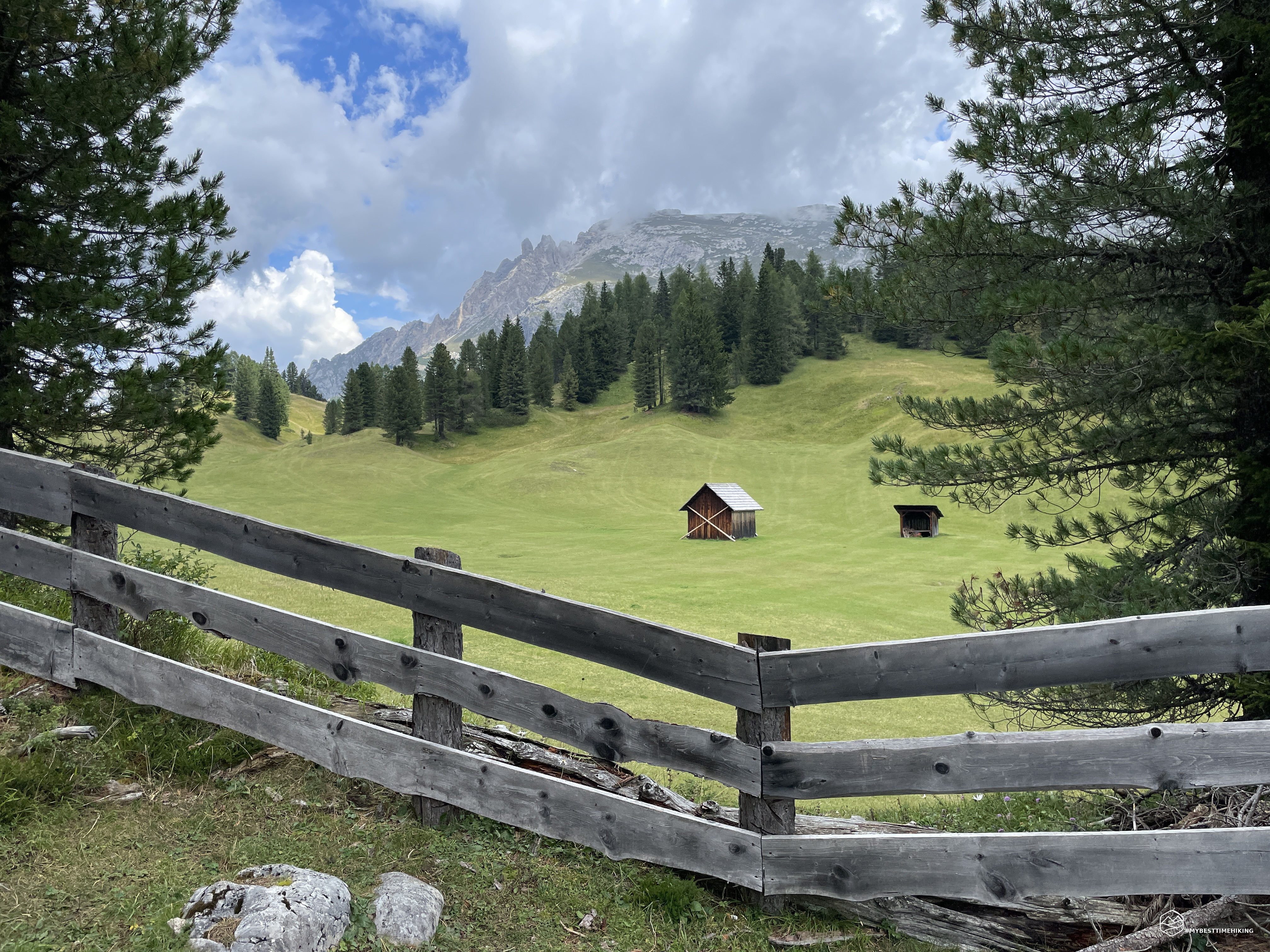
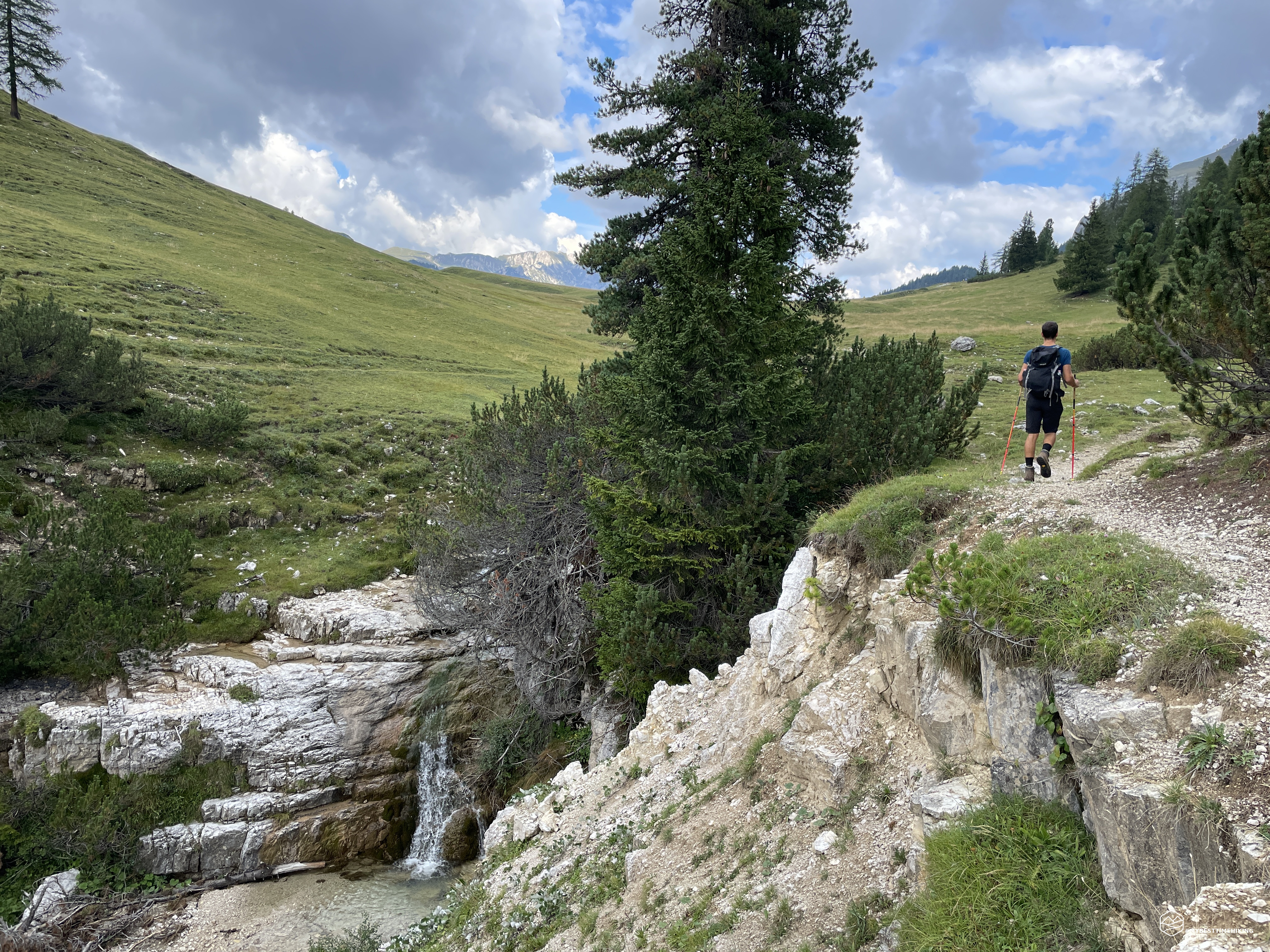
We find a track on the ridge in Val di Specie that runs along CAI path 37 at a lower altitude towards the Vallandro refuge. We remain low, we do not have to reach the refuge but aim directly for the meadows. We juggle the pines to follow this well-marked track, even if not present on the map. We find ourselves on the rocky ridge that joins the Pratopiazza meadows at the height of a beautiful waterfall created by sheets of horizontal boulders that gently degrade in the first section and then let the river disappear into a deep impluvium created by the ridge where we are in this moment and the Knollkopf, or Col Tondo. We are on the splendid Pratopiazza meadows: a boundless green expanse dotted with small huts offers a relaxing and spectacular view. On the right stands the Picco di Vallandro while on the left the legendary Croda Rossa awaits us.
We cut through the meadows and enjoy a nice gallop in the short grass still wet from the last rains. We reach the CAI path number 3 which leads to Malga Stolla. We pass the crossroads that would lead us to the hut, we continue until we cross a large river bed that points in the direction of the hut itself. At an altitude of about 2000m there is a bifurcation with a track not present on the map and which points in the direction of the Croda Rossa. We take the left track, leave CAI number 3 and, between grassy ledges and isolated boulders, head towards the final part of the Cime Campale. We go straight up choosing the most comfortable way, the grassy cushions soon give way to comfortable rocks. The Cime Campale are getting closer and closer and divide Cadin di Croda Rossa and Cadin del Ghiacciaio. On the way we find numerous war relics. The surprise is that they are not from the Great War but from the Second World War. This place, in fact, was a shooting range during these dark years. At an altitude of 2300m we reach the base of the Cime Campale with the red rock of the Croda in front of us. Here we find large boulders stacked on top of each other where you have to be very careful to proceed without getting hurt. The rocks are sharp as blades therefore, also to make a grip with the butsni and support yourself, you must have the utmost prudence and foresight. We proceed northwards, bypassing the rocky ridge of the Cime to reach the Cadin del Ghiacciaio.
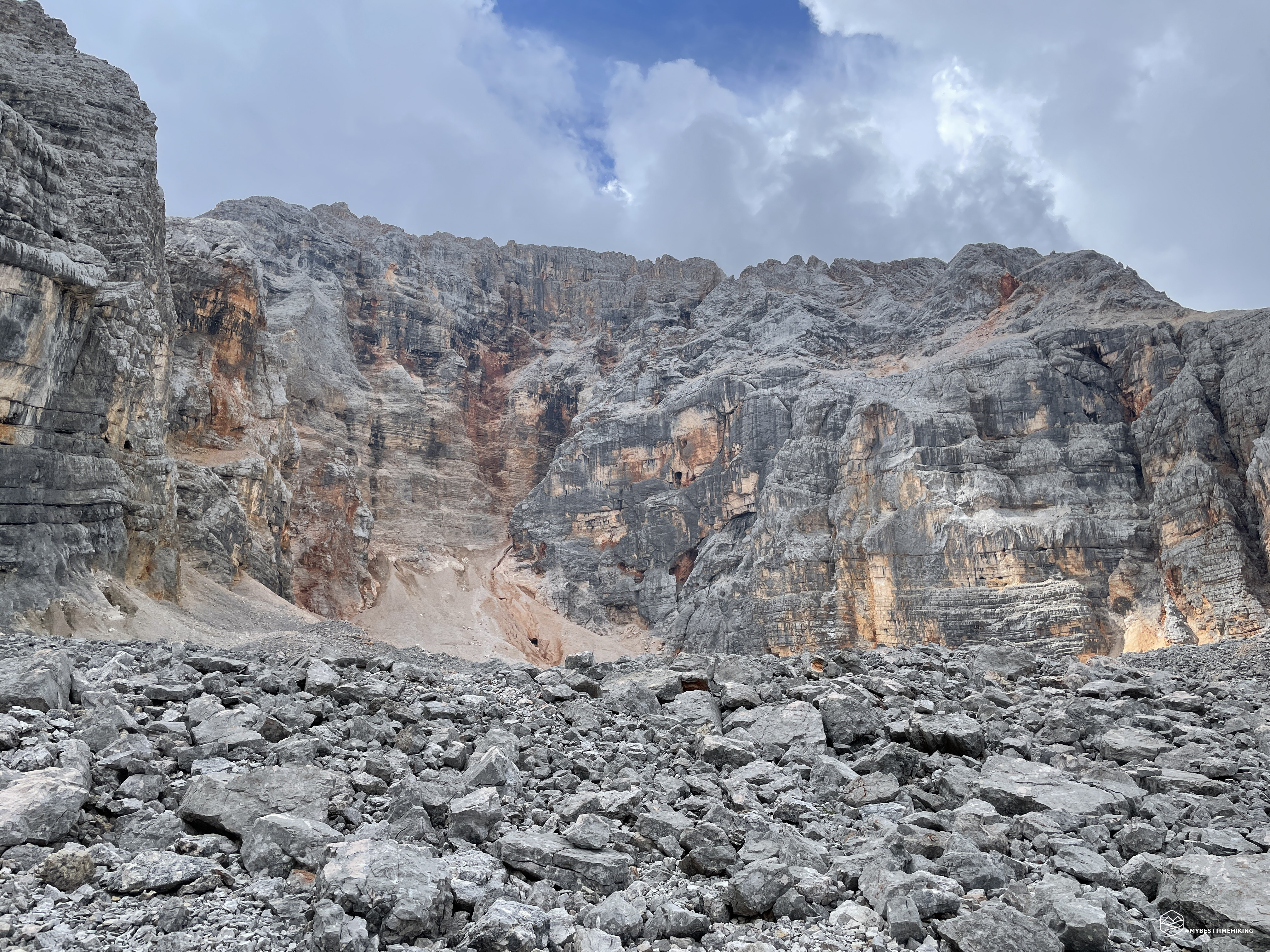
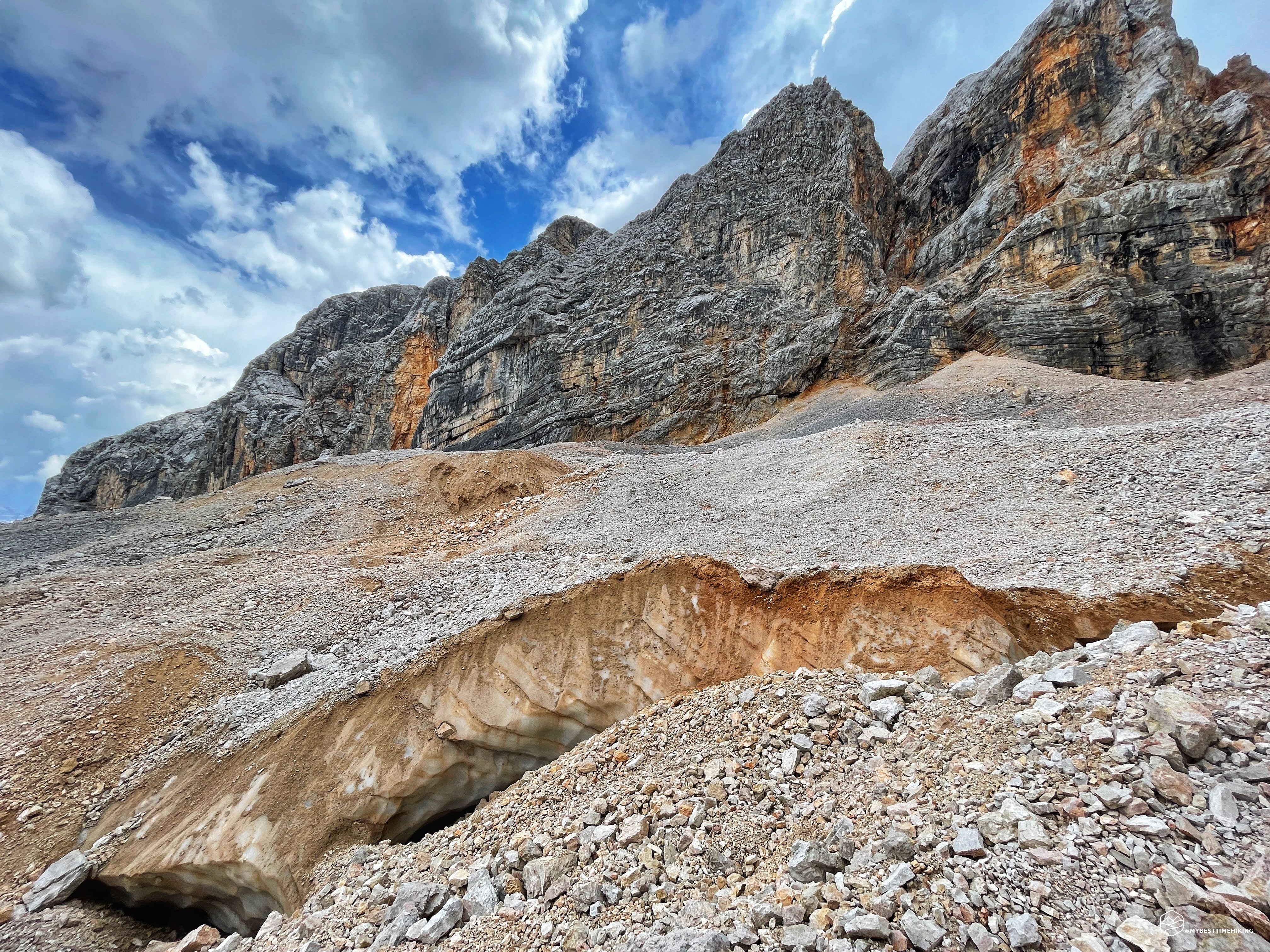
The rocky boulders give way to smooth stones stacked one on top of the other and create a natural terrace on the Cadin del Ghiacciaio. Here we see the first show of the day. I start from the sky, of an intense blue in the cloudy patches of pure white that kiss the spiky peaks of the Croda Rossa. The short pinnacles descend and gradually become more substantial and one with a series of rocky walls first of an intense gray color, then pale gray to vary to ocher yellow, orange and finish in the most intense brick red that can be seen in the eastern Dolomites. At the base of these walls, which form a natural amphitheater, a stony valley formed by more or less regular stones, stacked to form several sinuous hills and which end in front of us in a vertical vertical wall formed by compact gravel of an orange color: the glacier moraine! It seems impassable, but thanks to a series of comfortable rocks we can reach a point where the portion of gravel to "climb" is minimal. With a little difficulty and sinking the boot to create mini steps we advance until we reach the end of the wall.
Date
12-08-2022
Distance
18.06 KM
Hike type
Hike
Ascent
1194 mt
- Mountain
Croda Rossa d’Ampezzo
- Address
Pratopiazza, Trentino Alto Adige, Italy
- Altitude
2402.00 m
- Refuges
Rifugio Vallandro
- Information
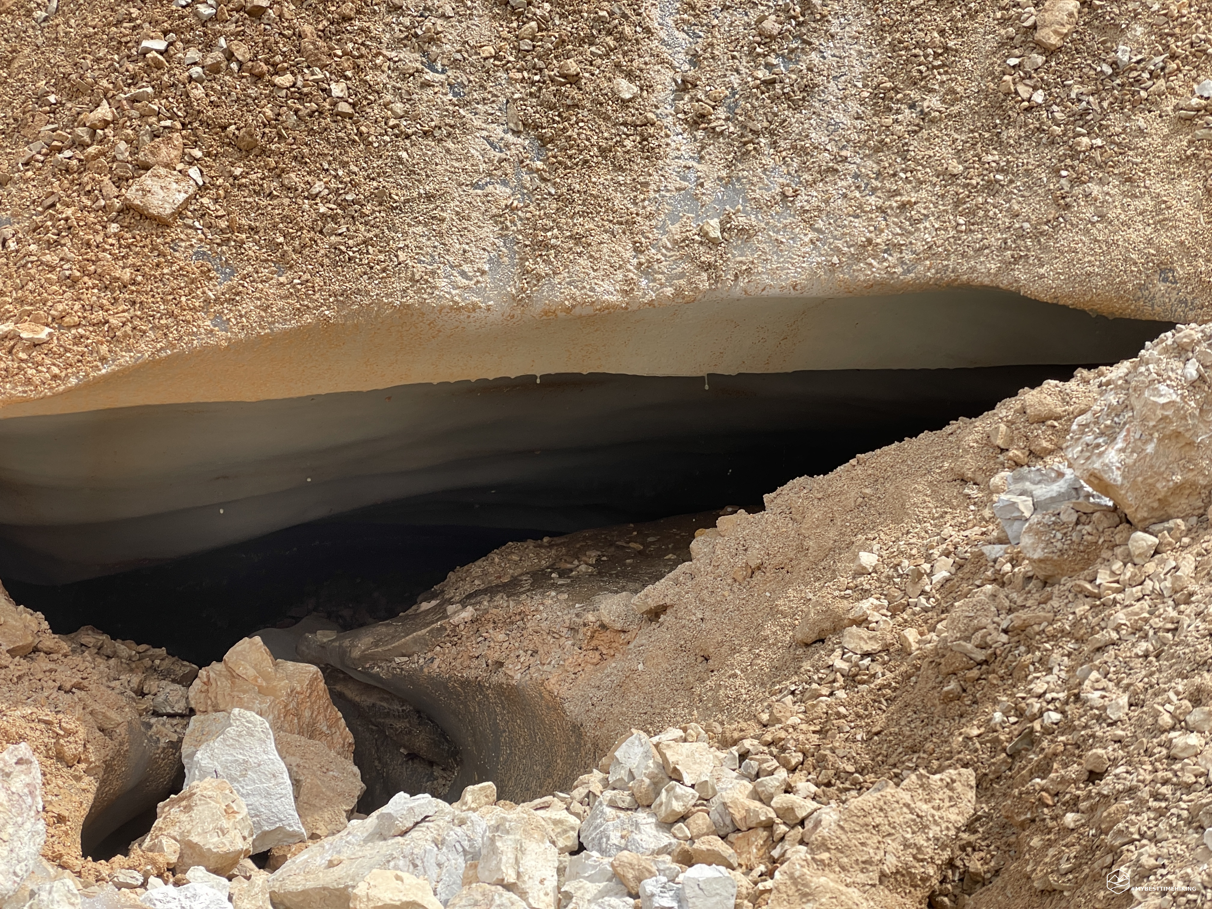
We have the whole valley in front of us, the Cadin del Ghiacciaio is here in all its beauty but… no view of ice. We are in fact in a rockglacier and the ice is under a thin layer of rock that covers it. Basically we are on an invisible glacier, which resists the harsh weather of our time and the great heat of recent periods only thanks to these rocks. The spectacularity of this place is that below us, under our feet, there is a world in continuous evolution: underground streams that dig, melting of the glacier that can give life to crevasses made invisible by rocks in balance just above. The mere thought of being on top of this hidden world fills me with immense happiness but also reminds me to pay the utmost attention to every single step: we are still on a glacier! The exploration of this valley begins and we discover that the glacier splits into two fronts. We are able to identify large cracks from which we can see the considerable layer of ice present under a thin rocky blanket above. Below, real and very deep caves return the sounds of water flowing constantly. Occasionally we also notice circular depressions which are certainly to indicate an underground cavity that is being created with the melting or movement of the glacier. The glacier is obviously suffering, but it is thanks to the presence of the rocks that it exists and that it still resists in these difficult years. We enter the valley up to an altitude of about 2400m, Diego points out the various rock jumps he had to face in the descent of the Campale fork ( here his report of the splendid adventure) right in the cross-section of rock of the Croda Rossa with the most characteristic color.
We move towards the N and, passing the northern front of the glacier, we discover an exceptional gem: a thermo-karst lake formed by the melting of a part of the glacier. I have not seen such a thing in the mountains and surely this is the most beautiful, interesting and unusual feature I have ever seen! A lake that is continuously fed by the superficial melting of a layer of the glacier of the northern front near the final moraine of the same. An evident ice wall surrounds it on the S part, while on the other side there is a wall of unstable stones. On both sides you can see continuous discharges of stones into the pond, the melting and movement of the glacier does not allow the lake to be still and calm: it seems almost populated by a myriad of small fish seen in continuous sketches, which however arise from impacts with small rocks. I immortalize him and document this marvel and we move again towards the N, in the direction of the unnamed valley.
On comfortable rocks we go around the moraine and arrive in the valley in a very short time. On our right stands the Crodaccia with a ridge of gravel that ends right where we are. In front, a rocky amphitheater is the end of the Crodaccia Alta, while on the left an imposing rocky spur divides the Cadin del Ghiacciaio with this Cadin di Crodaccia. This is how we baptized this nameless valley: Cadin di Crodaccia! It seems it is possible to reach the two Cadini through a thin saddle on this rocky spur that divides them. And here is the last beauty of the day: a chamois runs on the scree of the Crodaccia and reaches the ridge with extreme elegance and ease.
We now go down towards E to rejoin the CAI path 3. We skirt a small impluvium keeping to the left along comfortable rocks and grassy crags. We thus reach the front of the glacier moraine on the NE side of the Cadin del Ghiacciaio and we notice a little further on the evident trace of the CAI path. Once reached we have a splendid view of the Tre Cime di Lavaredo. At first stony, the road crosses a grassy plateau with grazing cows, and then returns to a track of stones and gravel with even fences and wooden protections to make it very comfortable for anyone. We reach the crossroads in the morning again and this time, however, we head straight to Malga Stolla to enjoy a well-deserved lunch.
From appetizers to desserts, we are filled up and, after a short break, we resume the track in the direction of Pratopiazza. Black clouds appear on the horizon, so we increase the pace (even if very heavy!) And retrace the same route of ascent. We have a spectacular view towards the Cristallo group where we see the perturbation that is running out right there and has left a shy fresh snow cover on the peaks of the Cristallo and of the Piz Popèna. The first raindrops begin fortunately very rare. However, we harness ourselves with the classic k-way and decide to walk the CAI path 37 for safety. At an altitude of about 1784m, just after a wide bend in the path we notice a track that cuts through the woods with lots of blue stamps on the trunks of the trees: the Troi dei milezinche! It takes us as soon as possible to the car, then we take it. This part we skipped in the morning is dotted with blue stickers everywhere, it's impossible to get lost. Even at the height of a fence there is a clear blue stamp with attached sticks to allow a comfortable straddle. We return to the fork in the morning where we left the troi and run back to the car. We can change before the flood begins!
This concludes a new exploratory adventure which had the legendary Croda Rossa d'Ampezzo as its protagonist. I never imagined walking on… an invisible glacier! Furthermore, the unusual sight of a lake formed by the melting of the ice with a looming wall to protect it is an unforgettable pearl! An excursion that he gave me and that will surely give emotions never experienced before to anyone who wants to repeat it. A route for expert hikers which, however, does not reserve any surprises from the point of view of mountaineering equipment or other critical issues.
For an even more complete and in-depth view, you cannot miss the reading of detailed report by Diego on the Windchili blog!
DifficultyExpert hikers - are generally signposted itineraries but with some difficulties: the terrain can consist of slippery slopes of grass, mixed rocks and grass, stony ground, slight snowy slopes or even single easy-to-climb rocky passages (use of hands in some places) . Although they are routes that do not require particular equipment, equipped sections can be presented even if they are not demanding. They require a good knowledge of the alpine environment, a safe step and the absence of vertigo. Physical preparation must be adequate for a fairly continuous day of walking. |