

"Wonderful weather, very sunny with clear skies in the morning and clear or partly cloudy due to modest mounds close to the peaks in the hottest hours." This is the latest ARPAV bulletin for the day that awaits us in the Dolomites. Diego and I leave early in the morning in the direction of Cortina where our rock awaits us, the Alpine guide Edoardo who will also accompany us in this new adventure. The weather seems anything but "wonderful": clouds upon clouds even tending to dark gray ... If a good day starts in the morning ... We are a bit discouraged: we don't want it to be a bad omen for today's expedition.
The goal is the ring of Monte Rudo, a peak that rises in the Val di Landro right in front of the lake of the same name. It can be reached from Cortina by continuing on the SS51 towards Carbonin in the direction of Dobbiaco. This mountain was the stronghold of the Austrian army in the First World War. It was here that several forts were located from which howitzers were aimed in the direction of the Cristallo group or the closest and "under fire" Monte Piana. We took inspiration from different sources, among all the report by Fabio Cammelli of summer 2020 published in the magazine "Le Alpi Venete", spring-summer 2021.
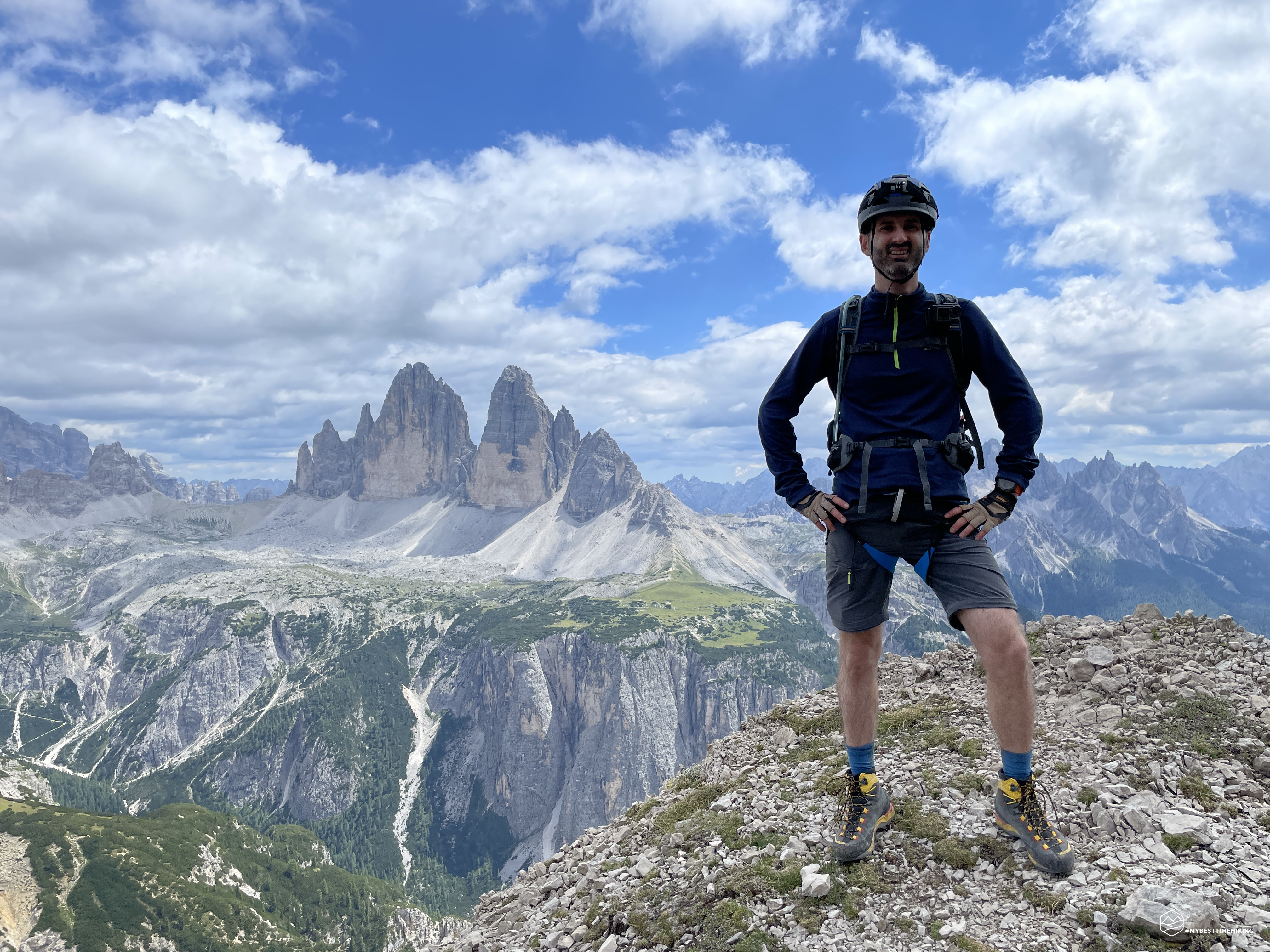
We pass Lake Landro, from which you can stop for a photo-postcard on the Three Peaks, and head a little further on the former Fort Landro on the right. A convenient open space allows you to park several cars. Here, waiting for us, we find Marco: a new member of the group of wild radishers!
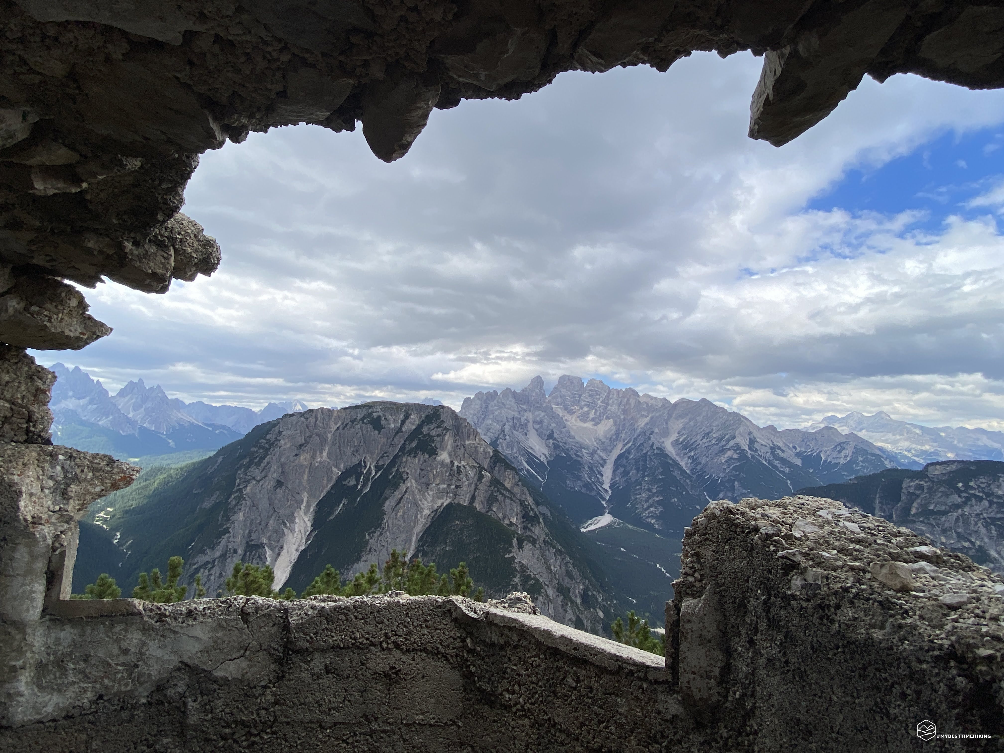
We start on a track that goes into the woods towards the NE. After a few minutes, turn sharply to the right (SE) overcoming a short stony stretch that has recently collapsed and return to the vegetation. On our right we see the former fort of Landro a few meters below our feet. We climb accompanied by shrubs of mountain pines (also recently cut) and gain altitude up to about 2000 meters where we begin to see the first dry stone walls, there for over a hundred years. You go up constantly in a zigzag way with sharp close bends until you come out on a gravel channel at an altitude of 2175 meters where we find the old Austrian fort. At one time, dotted with masonry shelters and bunkers, it was also the destination of a cableway. Today the remains allow to have unprecedented views on the splendid group of Cristallo, Cristallino di Misurina and Piz Popèna. In front of us, very close, the flattened shape of Monte Piana. Precisely from these positions, on July 14, 1915, repetitive bullets were dropped on Italian soldiers. Antonio Berti in the book "War in Ampezzo and Cadore", wrote as follows:
[...] At 9 o'clock precisely from Col San’Angelo a rocket rises: it is the signal for an attack. The infantrymen begin to advance in the direction of the Carducci Pyramid. When all the artillery of Monte Rudo, Prato Piazza, Col di Specie appear on the edge of the South Plain, they open fire at the same time. [...] An infantry battalion comes as a backup and also occupies the entrenchment that flanks the Pyramid. The soldier, on that uncovered plateau, sees the mighty and sinister mass of Monte Rudo rise in front of him, close by, with cannons hidden in caves that fire safely, uncontrollably, from their latèbre.
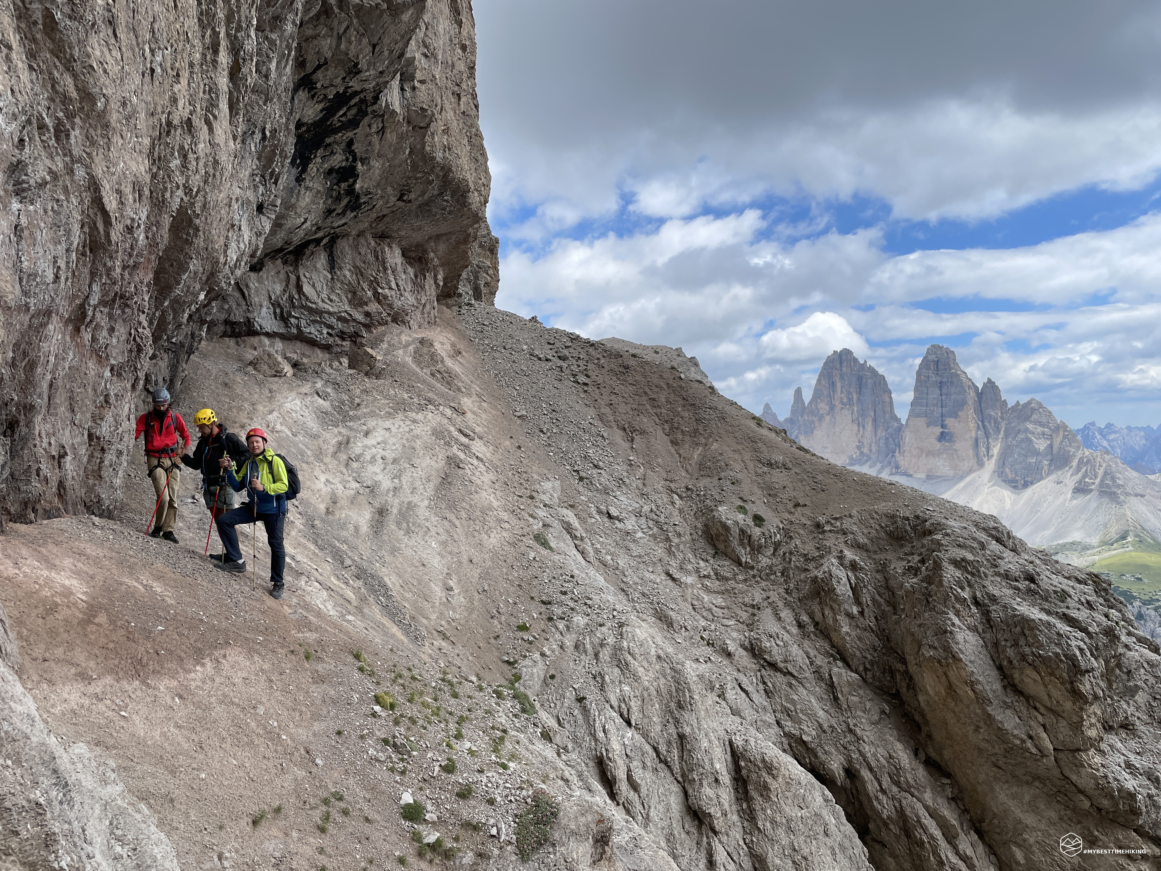
A short break and we leave again in the N direction on a path of stones (various cairns that indicate the way) and easy rocks that we climb at speed to reach the apex of a ridge. We arrive at the slopes of the Teston di Rudo wall, turn right on a very narrow ledge from which we notice a decisive rocky jump towards the valley. We continue to climb thanks to this uncertain path, until we reach a steep road created by rocks and debris from which we exit on the left to make an exposed passage on a rock jump of a few meters. From here, continue along the coast on a wider detrital ledge than the previous one. The chasm at the end is always marked, but it is possible to progress quickly, without difficulty. Particular attention is paid in some stretches where the more protruding rocks require a support with the hands for greater safety. At the end of the ledge the track opens onto a small valley of grass and stones that we go up in a zig-zag way. On the right we see a large gallery from which you have an exceptional view of Lake Misurina.
Most likely this place is the same one mentioned by Antonio Berti in this passage from "War in Ampezzo and Cadore": May 24, 1915. At 8.45 a roar makes the men start, petrifies them on the forks, standing upright, with suspended in hand the hoes and spades. A few seconds and another roar, a cry from all the breasts at the same time: "the war!". The two shots were fired on the Monte Piana plateau from that stony, massive, grim mass that looms over Landro and dominates Monte Piana: from Monte Rudo that the Austrians transformed into fortress. […] Throughout the 24th May and the morning of the 25th, Austrian medium-caliber pieces, stationed in the tunnels of Mount Rudo and Mount Specie, continue to beat the Forcella Lavaredo and Forcella Col di Mezzo. Numerous bullets, from 4 pm onwards, hiss over and explode in Misurina: the sheet of ice, which still covers a large part of the lake, melts in 48 hours. (note that at the end of May in those years there is it was still the frozen Misurina lake !!!).
We thus reach an altitude of about 2500 meters, we go out on a grassy shoulder that gives us two spectacular views: one on the majestic wall of Monte Rudo Ovest with the obvious track that we should travel, and the magnificent view of the Three Peaks accompanied by a imposing ruin of the Great War. As reported by Fabio Cammelli in his report: This construction formed, together with numerous artillery and observation posts, the so-called “Kampfanlage Schwalbenkofel”, an integral part of the Landro barrage. Between 1915 and 1917 it was used as a warehouse and as an inhabited shelter. We need a short pause to study the visible path in front of us. We also notice a couple who are anticipating us on the route but deviating in the scree towards S-SE: they have decided to use the last "escape route" to reach the Rienza Valley and not continue on the war path.
We, on the other hand, safe, take the path that first descends until we reach a gravelly ridge that goes towards the Three Peaks from which we have a splendid view for a souvenir photo. This is the point where the couple of hikers chose to opt for the alternative to the Rienza Valley. We reach the base of the western rocky pillar and from here our adventure on the southern side of Monte Rudo begins. As before, it develops first on a landslide ledge, and then continues on ups and downs and steep sandy slopes interspersed with recent impluviums created by landslides and landslides. We arrive at an altitude of approximately 2510 meters where we finally rest our feet on a wide grassy saddle and guarded by a large cave, also dating back to the Great War. From this point begins the most demanding part of the whole route.
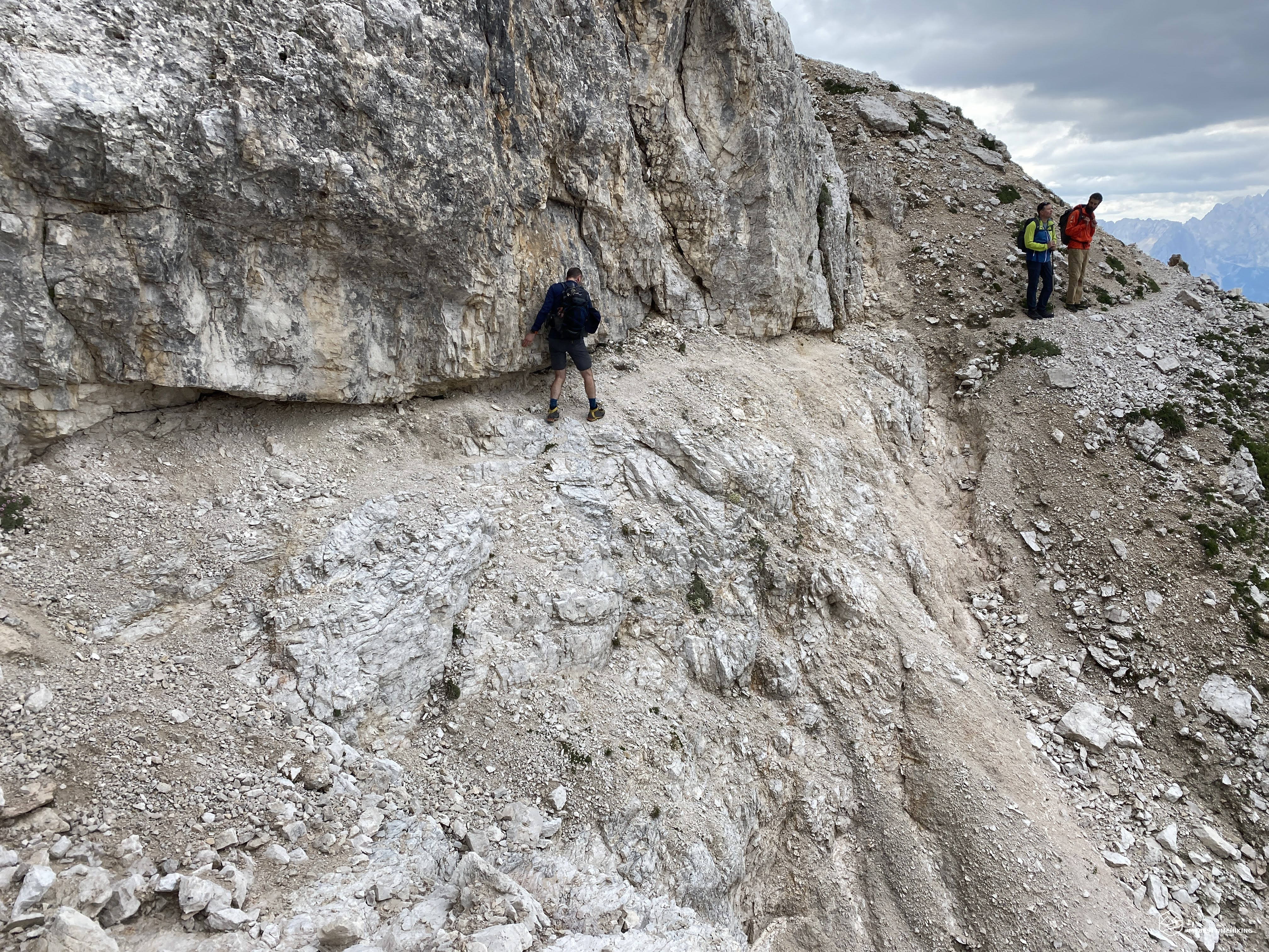
The path descends and then evidently climbs up sharply on collapsed slopes towards an edge from which an unmistakable little man stands out. At the end of the first part of the descent we find a piece of track swept away by a landslide. Fabio Cammelli also mentions it in the 2020 report but, in my opinion, only marginally. You have to go up briefly relying on turf and then continue on a very narrow rocky track. The collapsed stretch is so short but very exposed, you need to pay the utmost attention to every step and not hesitate too much: who knows how long there will still be this minimal passage in which there is hardly one boot in front of the other. Once you set foot on the ledge scree, it feels like you are on a highway in comparison!
Date
31-07-2022
Distance
15.29 KM
Hike type
Alpinism
Ascent
1481 mt
- Mountain
Monte Rudo
- Address
Val di Landro, Trentino Alto Adige, Italy
- Altitude
2675.00 m
- Refuges
- Information
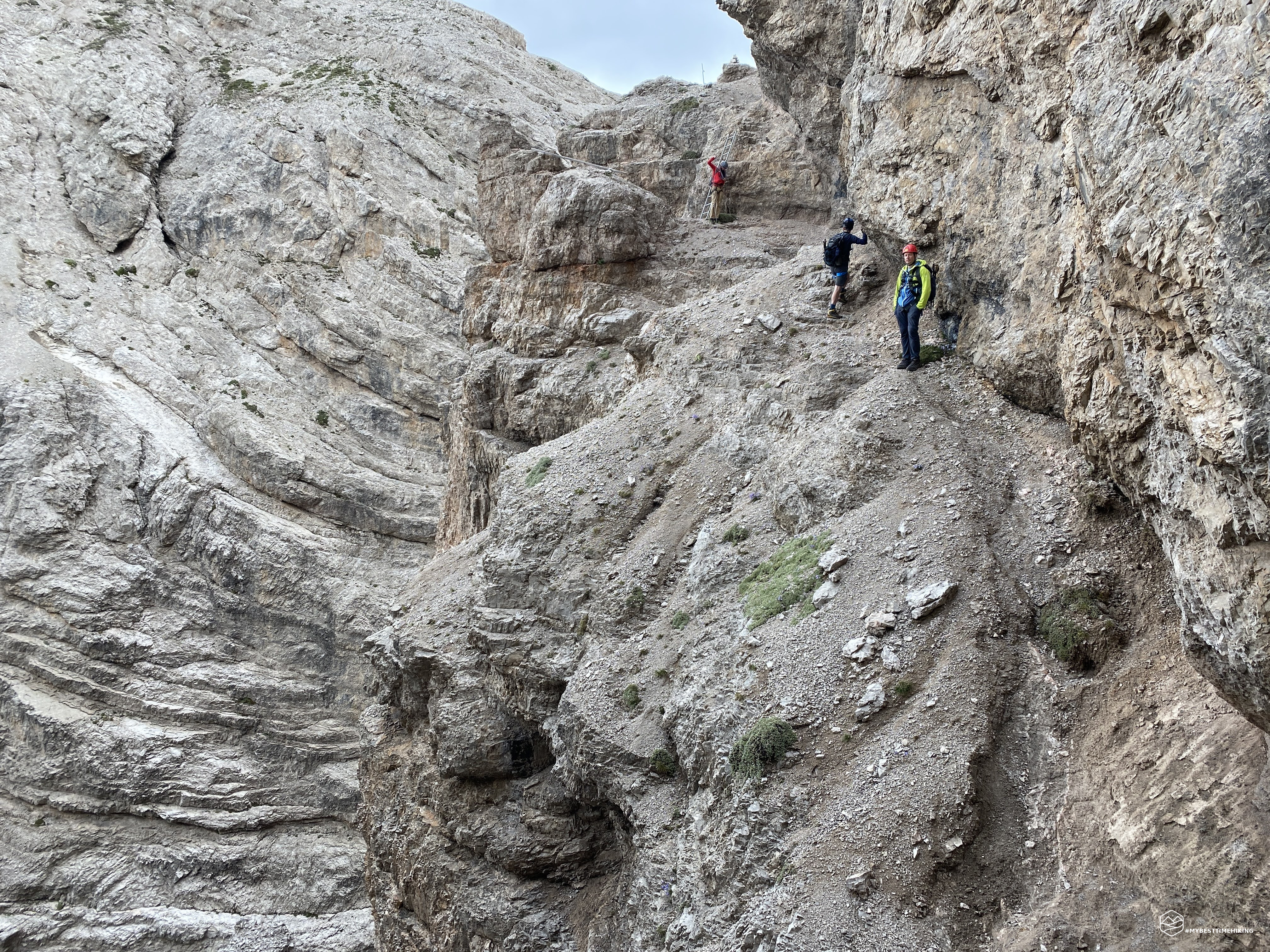
We reach the top of the rocky edge with no little effort given the slope and the presence of fine gravel in some points. The view leaves you breathless: in front of us the Three Peaks stand out and looking down the legendary ladder! From Fabio Cammelli's report it seems that this is the key point of today's adventure. The first difference that I notice is the old wooden staircase that was literally thrown over a rocky ridge. The way to reach the rock jump with the ladder is a very narrow strip of land, on the edge of the wall, with a very exposed overhang. Indeed, with calm, coolness and a steady step, you shouldn't have difficulty passing it, but we opt for safety. Edoardo goes ahead to see if there are points in which we can ensure. The only grip is an iron tap root well planted on the ground in the widest part of the rocky edge where we are waiting. Diego leaves first. He safely walks the exposed stretch, overcomes the mini steps and reaches the edge of the rocky jump. Here, an (electric ?!) wire is attached to an iron taproot, which is in turn tied to the metal ladder. Diego tests the solidity of the taproot and… it remains in his hand! Literally the piece of iron comes out almost without resistance as a pencil comes out of the sharpener. Between shy laughter and growing concern, Diego leaves the taproot on the ground to prevent others from relying on this now obsolete tool. The perplexity is the stability of the ladder now that there is no wire or fine rope to keep it fixed (as if a wire could keep a ten-rung ladder fixed). The ladder wobbles, but Diego with the weight towards the mountain manages to descend it completely. He touches the ground, he releases the carabiner and so Marco and I retrace the same steps. Diego holds the ladder steady and we safely descend towards the limited gravel base. We are now waiting for Edoardo who, once the rope has been recovered, reaches us in a flash. We note that the ladder is anchored with a nail fixed in the rock, and with a couple of ropes (very fine in my opinion). The worst seems to have passed… and instead. The stretch that awaits us is as exposed as the one just passed. We decide to proceed safely, but there are no safety holds, apparently. Edoardo tries to insert a nail, for several attempts, without success: the rock is really rotten and does not guarantee a minimum anchorage. He then decides to use the only fixed nail already present: that of the ladder. Diego is the avant-garde and finishes the short exposed section in a very short time. Marco and I follow suit. Edoardo joins us with his usual gracefulness.
We proceed uphill with detrital terrain, we turn continuously to observe the piece just traveled: it is really characteristic with sheer pinnacles and the narrow stony tongue that allowed us to stay on the coast. We go out on a new grassy terrace with a clear military post with a dry stone wall to protect the cliff. A little further on, a second war post on the edge of the cliff. The view is priceless: an amphitheater on the Tre Cime di Lavaredo, Monte Paterno, the Sasso di Sesto and the Torre dei Scarperi. From the stations it folds left onto a mixed grass ridge. Pay particular attention to the cairns present: it is necessary to continue climbing the ridge on rocky steps and not to lose the evident signs arranged along the progression which lasts for about 50 meters in altitude. The last piece is the most challenging with a passage on easy rocks which, however, is a bit exposed. You climb onto a safe and beautiful wide saddle that concludes the circumvention of the Rudo di Mezzo coast.
From now on the path becomes less exposed and simpler. The track continues at first at high altitude and then climbs up rocky steps, in some places it seems to have slabs of marble under your feet. We go up on grassy zigzag crags and then continue on wide detrital ledges dug in some points by landslide impluviors. In this section the path is always quite wide and constantly marked. We arrive at a final stretch where the rock and the earth under our feet are bright red. From here, past the last protruding rock, we see the white gravel gully that takes us to the saddle.
The path that leads to the right leads to an unnamed saddle and then to the track that allows you to reach the Passo Grande dei Rondoi and consequently the Rienza Valley is very evident. We, on the other hand, aim to the left straight to gain the last 40 meters in altitude to conquer the Forcella dei Rondoi. We chose to go up the hill on the left (orographic right) because we found some gravel that guarantees excellent progression together with occasional grassy pads. We are at an altitude of 2672 meters where a small cave and some military remains welcome us in the fork. We enjoy the splendor ido panorama towards Lavaredo on one side and the unknown Val Bulla on the other.
We mentally prepare for the descent. From the various reports all agree on the difficult starting piece with hard gravel. Surprisingly this is not the case and we almost have fun in a "ski" as in the most classic screes. In some places the gully becomes more difficult but not to be counted among the most difficult screes made so far. Once you reach the base, a grassy terrace opens up with the presence of pines and more voluminous boulders. We are at an altitude of about 2080m in the medium-high Val Bulla. Imperious boulders from a massive landslide have crashed in this area. We find a shy path between the grass and the boulders (little man) and we move to the orographic left of the valley. We continue on these obvious traces until we reach a dense patch of pine trees that blocks the road: about 2000mt altitude.
We note that there are two possibilities to overcome this limitation: go back a little, gain the position of the pines on the orographic right of the valley and then pass several (theoretically 3) impluviums whose composition and position we do not actually know where we are it is not possible to have more details. Or, descend into the impluvium bristling from the edge of the "wall" of pine trees in front of us, proceed along the scree and reach the confluence of the Rio Rondoi. We choose this second option which means mini ravanata in the pines (I was actually starting to miss) and descended 20-25 meters in the impluvium. This time I lead the way and, once Edoardo has wisely anchored me to a mountain, I safely descend towards the dry shore. I release myself and await the arrival of the next one. I don't move far enough and, at the beginning of Marco's descent, I see myself being reached by a series of crazy stones. I don't know how, but none of them hit me! At a good pace, therefore, I descend quickly leaving room for descent for my companions. At Edoardo's time I see a chamois, or as Diego has labeled it, a "spider" that reaches us in no time at all. The descent is not as playful as the beginning of Val Bulla but in any case without difficulty we arrive at the confluence of the Rio Rondoi impluvium. Now we deviate decisively towards the West and walk along the dry shore on large stacked boulders, choosing the best route by eye.
Once you are almost at the bottom of the valley, where the groove of the impluvium widens and becomes less steep, you can easily go up the gravel barrier on the left that acts as a bank. We walk along it quickly and at the height of a powerful Austrian fort clearly visible on the left we see an easy path that descends into the vegetation. In this fort there was an Austrian cannon directed towards the Cristallo, photo from a book by Antonio Berti. Going around the military post we find the old mule track now almost swallowed up by the vegetation but still wide and clearly visible. Last meters of elevation gain that lead us comfortably to the parking lot of the departure and consequent closure of the ring.
Thus ends an excursion that is stimulating to say the least, demanding from a mental point of view less from a physical point of view but which contains significant mountaineering problems due to the strong exposure in some points. The itinerary is certainly complete from every point of view:
- Historical, due to the presence of a war path that allows us to relive the sweat, the danger, the cunning and the ardor of an indelible page of our existence;
- Landscape, thanks to the incredible panorama of the Ampezzo Dolomites such as the Cristallo group, Piz Popena and Croda Rossa. Passing through the Cristallino di Misurina, Mount Piana and the majestic Tre Cime di Lavaredo;
- Exploratory, Mount Rudo due to its conformation is constantly evolving and eroding. The path changes from year to year and the difficulties begin to be more and more evident. Val Bulla is the typical expression of how a valley can be upset by continuous landslides and landslides.
For an even more complete view, I invite you to also read the splendid and detailed technical report of the legendary adventure companion Diego!
DifficultyExpert Hikers with Equipment - The equipped routes (or via ferrata) are indicated, they require the use of self-insurance devices. |