

Sedico, Belluno Dolomites.
Clear and pungent day in the early morning. Companion of today's adventure is the legendary Diego: when there is to "ravanare" and discover new routes, it can only be him! Today's goal is Mount Peron, a mountain block that some attest to as the final part of the Schiara group.
Also named by the historian mountaineer Ottone Brentari in his " Historical-Alpine Guide of Belluno-Feltre-Primiero-Agordo-Zoldo " of 1887: " Peron, a few houses built near a large boulder (pietrone = peron) who gave the name to the place ". The historian does not report more details regarding the ascension of this rocky block which gives its name to the town below. For this reason, it is imperative to try to reach it and to do it in the best possible way: by exploring the area through unprecedented and spectacular routes.
From Belluno we quickly reach the town of Peron, leave the car on the left of the state road, in a parking lot overlooking a Tibetan bridge that allows you to reach the fascinating Certosa di Vederna with the imposing Piz de Vedana that overlooks it.
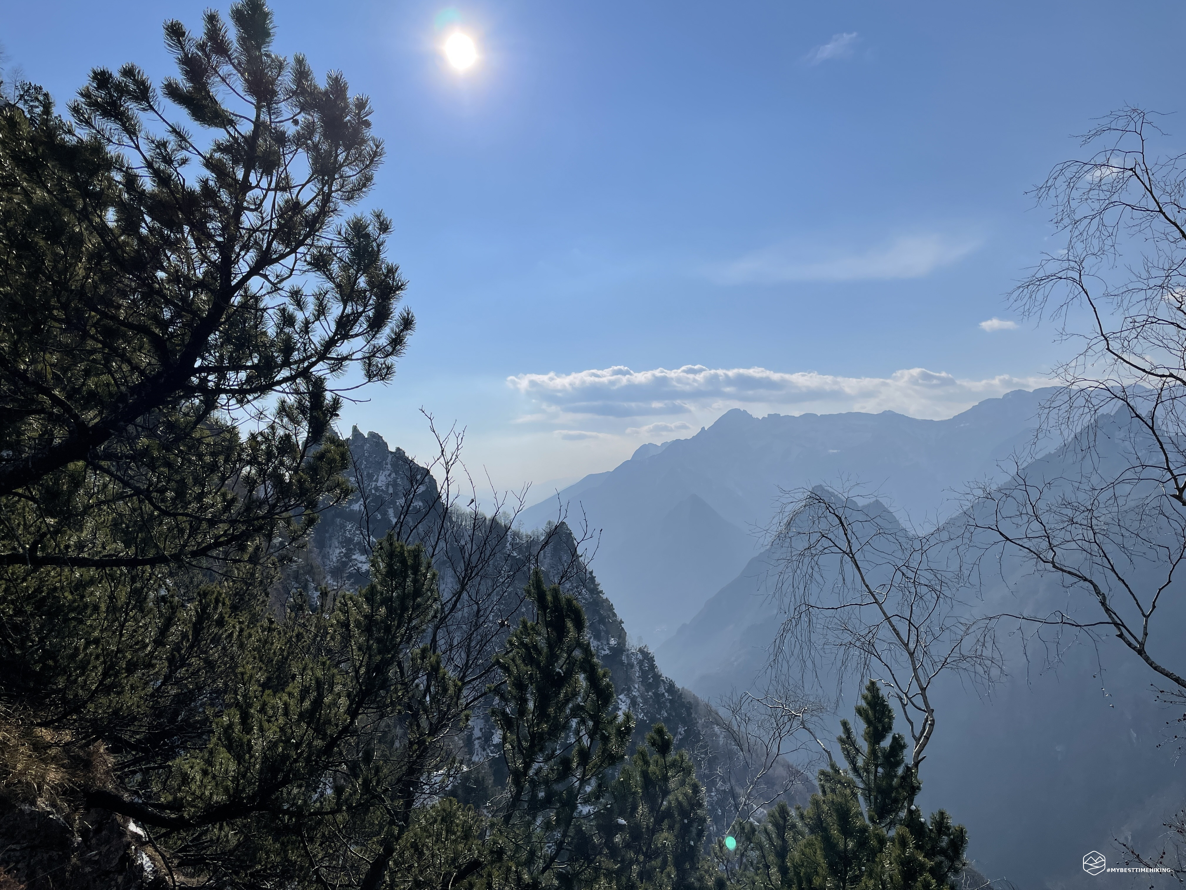
We fasten our boots, rucksack and head to the town of Peron, climbing a narrow and bristling street. After a few hundred meters, the road gives way to a shy path well delimited by small dry stone walls. The area is semi-wooded born on an old landslide of which you can still see large boulders stacked on the sides of the track. This path is a CAI route marked on the map as "Themed Path Chiesette Pedemontane", this path continues to the right crossing a landslide just below the looming peak of Peron and continues towards Pian de Fraina. Obviously we choose the deviation to the left, at an altitude of 600m, on a path that was at first clearly evident on a new grassy stretch. This track tends to the northwest following the Peron coast. You gain altitude very slowly until you reach a small rock jump of a couple of meters to climb with ease. We soon arrive, with the path that gradually disappears, to the Col delle Pere from which you can glimpse the magnificent gravel bed of the Cordevole stream below us among the foliage.
Our idea is to reach the saddle to the east of Colle Salere and then go up towards the crest of the Pale di S. Giorgio. We make this prediction by carefully studying the Tobacco map, where only green is marked, which equates to portions of vegetation only. We leave Col delle Pere heading north, trying to gain altitude in the direction of Colle Salere.
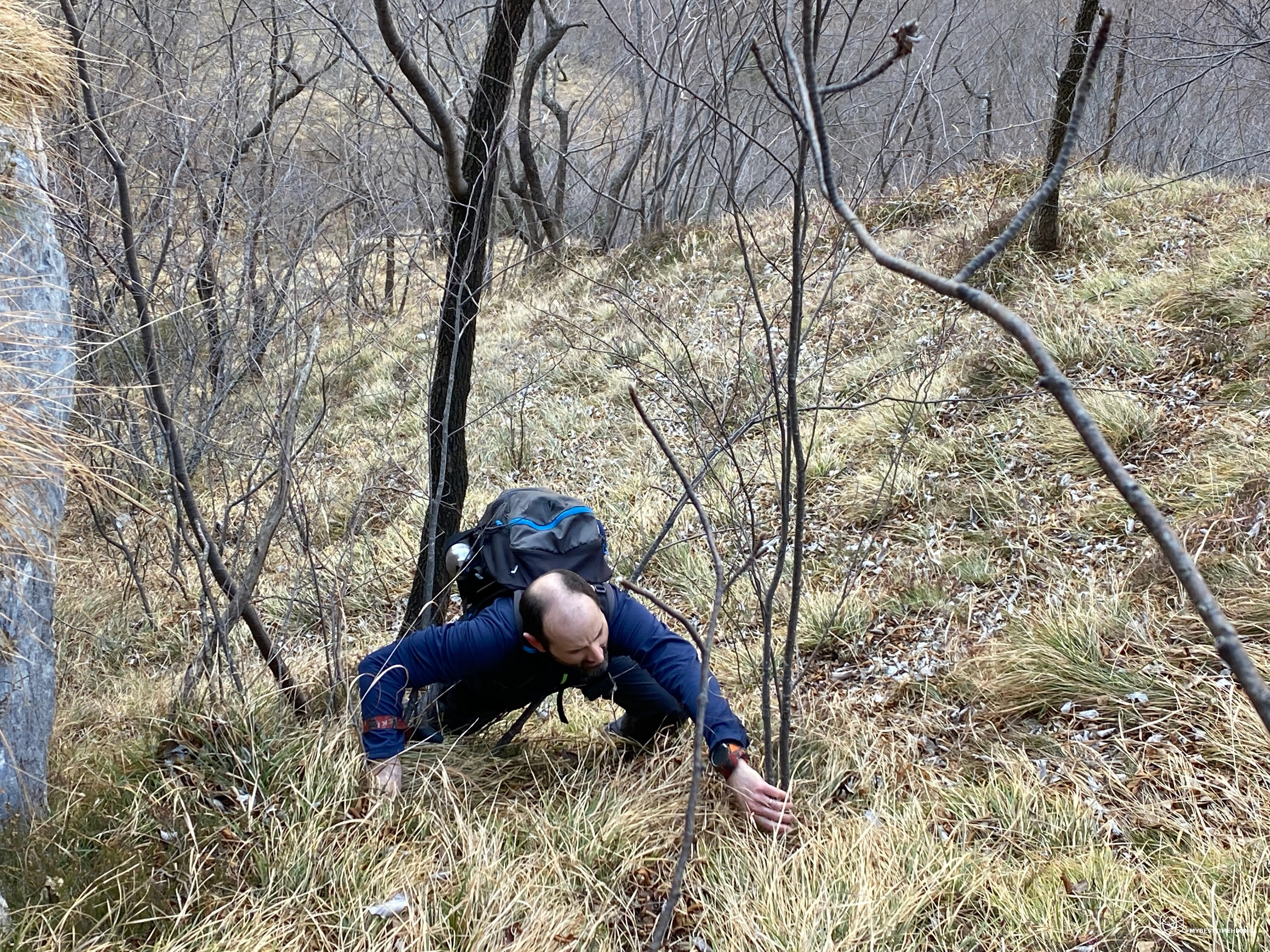
In fact, we leave the faint trace to begin the real exploration on a ridge that becomes more and more pending and difficult. One can imagine Ottone Brentari in 1887 that from the Cordevole valley, he looks in the direction in which we are: “ […] you arrive towards the stream. Beyond this, the Cordevole valley opens up. […] The valley begins to get narrow closed by high walls. Beyond the stream is the Col di Salet [...] ”. The Col di Salet is in fact the Colle Salere and the "high walls" have remained intact from 1887 to today: the slope in fact becomes more and more sustained. We have to climb between grassy crags and shrubs which fortunately allow us to secure and advance by holding on to force. We overcome a stretch at the base of a rock wall of about ten meters. The climb is increasingly vertical. Thanks to the birches, the tufts of grass and the roots you continue to climb easily but, turning around, you can see that the progression is taking place almost on a vertical wall. It is here that among the slightly denser foliage I place myself on a tree to gain a more comfortable position and that allows me to catch my breath and strength: a branch acts as a sling and from below lets my water bottle out of the external pocket. A dull thud, followed by two others, then a continuous succession of hissing towards an unknown destination. For the last time I see my bottle, a memory of Mont Blanc, disappear into the ravine and with it the liter of hot herbal tea inside it. The cold is bitter on this northern side and a hot drink would have been very tempting. I do not despair, I greet the bottle knowing that I will not be able to retrieve it (who knows where it stopped ...).
We are over 960mt, we see a softening of the wall and here is Colle Salere. From here the problems begin: our goal was to go down towards the bed of the stream east of the hill and go up on the grassy ridge in the direction of the Pale di S. Giorgio: impossible! To the east of the hill we see in front of us a very deep gorge with sheer rock walls. The same hill on this side is practically on live rock. Diego tries to go on a reconnaissance to see if it is just an appearance, a small trait: no. The entire bed of the stream, tens of meters below us, looks like a canyon bordered by two inviolable rock walls. We are many disappointed by such a serious lack on the part of the Tobacco cartography: these jumps of rock are absolutely not marked at this point!
Date
06-03-2022
Distance
13.40 KM
Hike type
Hike
Ascent
1238 mt
- Mountain
Monte Peron
- Address
Sedico, Veneto, Italy
- Altitude
1371.00 m
- Refuges
- Information
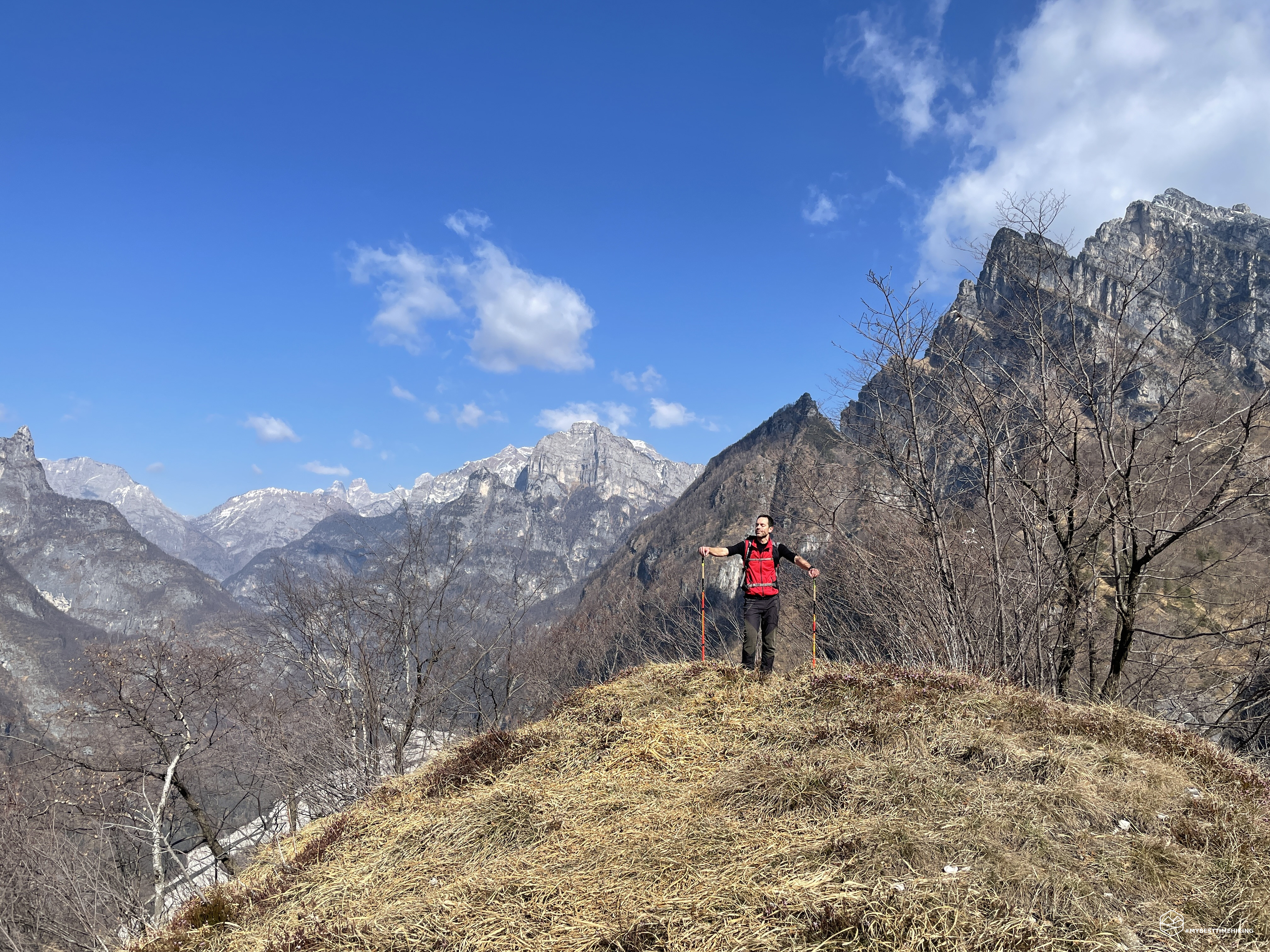
We return to the top of the hill and then decide to reach Colle Scalon and from there resume the trace of the path just below towards the West. We walk along a comfortable grassy ridge and reach the top of Colle Scalon. From here a beautiful view of the Monti del Sole. The matter here is again critical. We think that the best way, again with respect to the Tobacco map, is to go down towards the north, on a fairly gentle slope to then rejoin the marked track. In short, we realize that there is a chasm in front of us! On the map it is marked further east, and in fact, after a brief survey we notice that there is a ravine there too! Our only way out seems to be towards the West on a truly risky slope, where only mountain pines, birches and other shrubs allow us to remain standing and proceed. A misstep here means being directly on the Cordevole! Diego continues in the reconnaissance of the safest route, but we constantly have to make changes and suddenly we have to force a return to the south to avoid some rocky jumps (again!). All the movements are made with extreme attention, an almost Zen calm always with an incredible cold: the thermometer marks 2 ° C and we begin to really suffer from it. After several changes of direction Diego notices a patch of snow further down: maybe it's the right time, could it be the path? To reach it, we spend a lot of time studying the right grip on the branches. It is close, we are almost there: yes, it really is the path! We are exhausted not only physically but also mentally: we know how to read a map and find ourselves in this tangle of difficulties, which at times seemed really insurmountable, have evidently marked us.
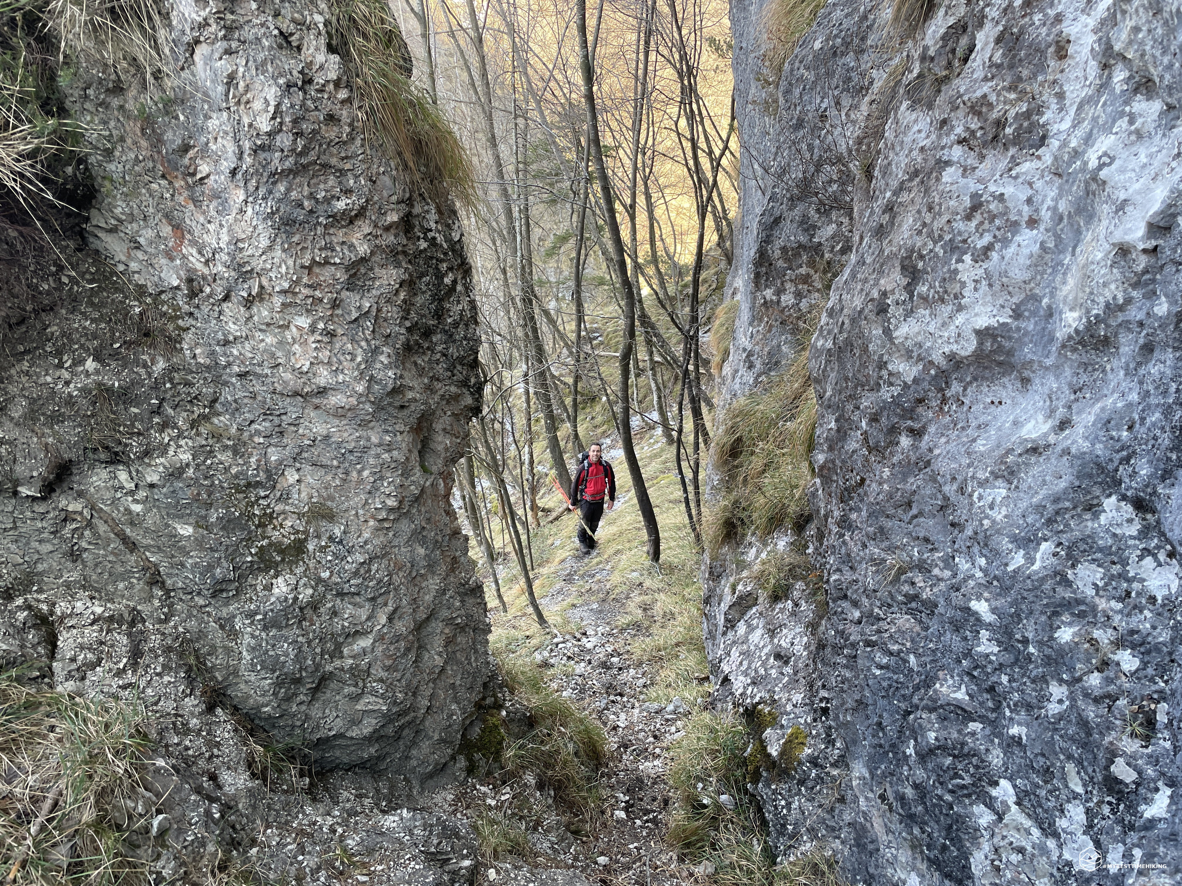
On the track you pass through gorges with rock walls of at least 20 meters: where were they on the map? They are not young rocks created following a recent landslide. These walls have been there since the time of Ottone Brentari: how can Tabacco cartography explain these gaps? We continue to struggle with these questions until we reach the first safe "oasis": Val Madonnetta with a comfortable bench covered with frost that allows you to have a beautiful view towards the Agordo Canal. We go down again until we rejoin the stream that must have been our original road, here we find an ancient charcoal pit and a sign "Forcella Costacurta". We are on the right track. Now there should be no more problems (…).
We gain a few meters in altitude and stop on an open space to make a short stop. We turn and notice the top of Colle Scalon from where we came down a little while ago: it looked like a crest overlooking nothing. We were incredibly impressed with where we were, with what slope and with the series of rocky walls that actually surrounded the entire hill. Even more satisfied with our exploratory expedition, we set off on this ridge which has again become mainly grassy. We then continue to Val Modunuta (Val Madonnetta) towards Col de le Frare. We arrive at the border with the Natural Park of the Belluno Dolomites and deviate, always on the ridge, to the east. The presence of some stamps and men reassures us that we are on the right path, even if we are definitely out of track with respect to the Tobacco app. Towards the Val Greva we see a straight abyss. We always keep in the direction of Pale di S. Giorgio at an altitude of 1100m the snow begins to peep out, there are no more signs of progression, we orient ourselves more by instinct than with the map that we now leave as our last choice. Suddenly we see a little man who heartens us just above 1200mt, altitude where crampons are needed. We go up not without difficulty the snow-covered ridge and with a considerable slope. The temperature drops below freezing (-1 ° C) and it's 2:30 pm. We reach the ridge, we see signs of boots, then a sign on a tree, we approach the CAI marked path. Here we are at Forcella Costacurta! Let's look at the Tobacco map and even the indication of this fork is totally wrong!
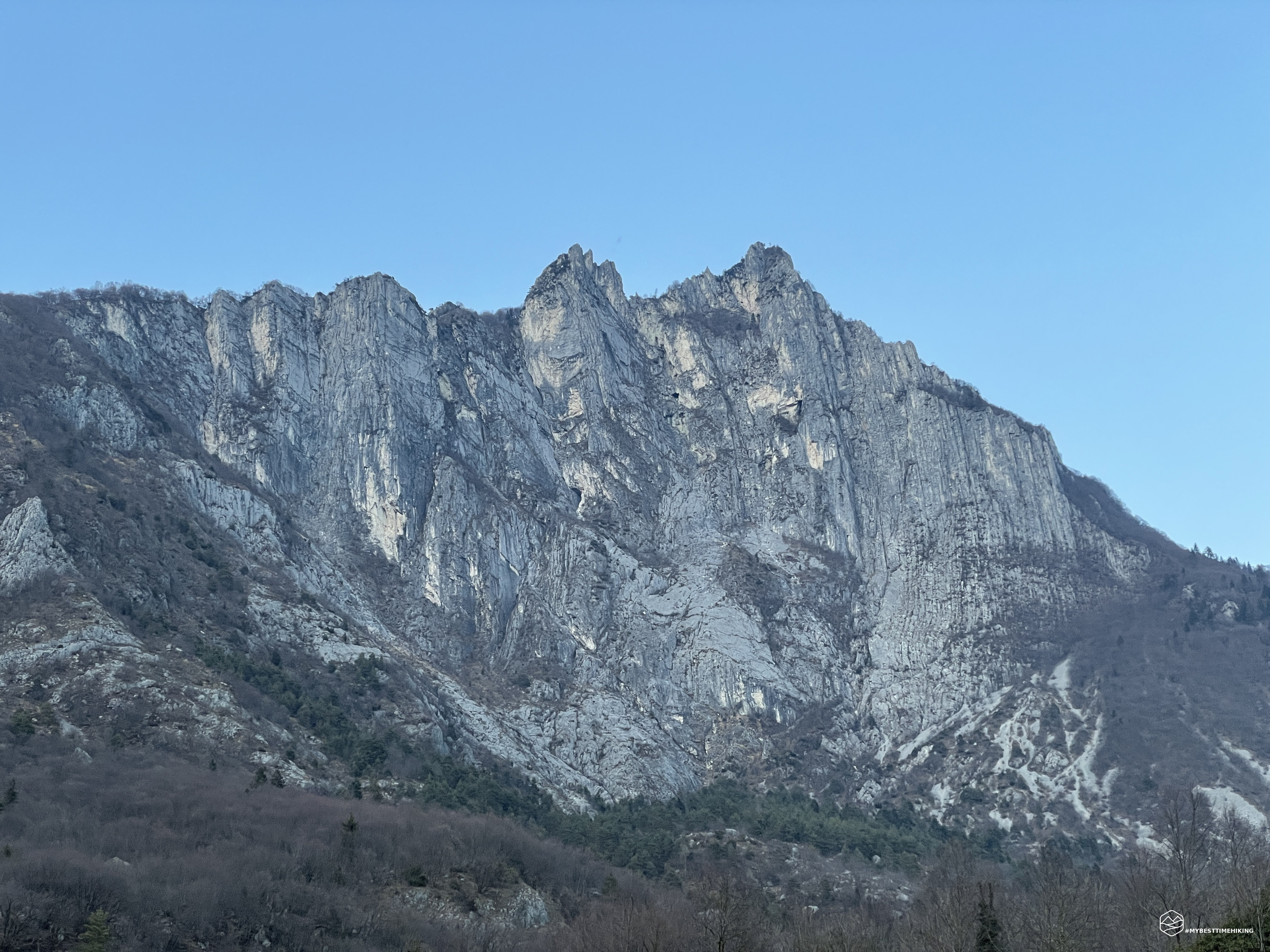
We keep to the right and walk along the ridge path that leads to the summit of Mount Peron. The climb is simple at first and then leaves room for more technical and exposed parts. At an altitude of 1371m I give up on the summit. A very treacherous crest for the season is ahead of us with sections secured with metal cables. The tiredness of the vicissitudes encountered in the morning makes itself felt and I am not happy in undertaking the ridge. Diego continues up to 1500m on a forerunner of the Peron, but he too gives up for the short time available. It is 3:30 pm and we have to get off. For this season, being still on top at this hour can become dangerous. While I wait for Diego on the ridge, I enjoy a wonderful view of the Monti del Sole: Col dei Rondoi, Mont Alt, Pizet and Cima delle Corale. Now we understand how to go down to the valley, it seems that a passage on the ridge is necessary but, surprisingly, returning to the Costacurta fork we see a beautiful sign "Pian de Fraina" and a mule track that goes down. Obviously, this track is not marked on the map. We trust the indication and throw ourselves headlong down the descent leaving the crest of the Pale di S. Giorgio. After passing an ancient furnace, now destroyed, we reach the Pian de Fraina car park where we see another anomaly: there is a sign with the words "Monte Peron" on the opposite side from which we arrived and, as usual, we don't this street is marked on the map! More and more dejected, we go down the paved road and try to reach the town of Peron as soon as possible.
At an altitude of 892m, near Costiet, we choose to take a track that should be a shortcut to Peron: once again we have cursed the Tobacco. The previously evident route disappears almost immediately, there is no longer any sign, no slightest stretch that could suggest that there is still a shy path here. We go down practically straight ahead on a slippery ground given by the leaves to resume the thematic path of the Pedemontane Churches as soon as possible. In the search we come across a path marked by signs indicating the presence of trenches from the First World War and a road descends in the direction of the town of Peron, apparently. This street is also not marked on the Tobacco map and therefore we take as a reference the map we have on our Garmin watches: here the track is there and it is marked! We walk along it, go down very quickly and continuously in the direction of the casere called Comui Bassi and, from there, we quickly return to civilization and the parking lot where we left the car.
Thus ends today's adventure made unforgettable by continuous surprises and program changes compared to what was estimated by studying the map in depth. A real exploratory excursion that allowed us to closely observe the conformation of the Peron from all its sides. A study that we would have pleasantly done at the table. We have seen the true harsh and rude nature of Peron which requires a great deal of experience, a spirit of adaptation and the ability to orient. An itinerary not to be underestimated especially for the western part.
For an even more complete and detailed view, I invite you to also read Diego's report on his blog WINDCHILI – AROUND THE WORLD.
DifficultyExpert hikers - are generally signposted itineraries but with some difficulties: the terrain can consist of slippery slopes of grass, mixed rocks and grass, stony ground, slight snowy slopes or even single easy-to-climb rocky passages (use of hands in some places) . Although they are routes that do not require particular equipment, equipped sections can be presented even if they are not demanding. They require a good knowledge of the alpine environment, a safe step and the absence of vertigo. Physical preparation must be adequate for a fairly continuous day of walking. |