


Autumn 2021 still offers wonderful sunny days and this Saturday at the end of November is perfect for an adventure in the wonderful Alpago! Today's hiking companion is Enrico, a friend and fellow mountain lover and photography enthusiast. The mild temperatures allow us to organize an itinerary with some mountains that can exceed 2000mt.
After a long search, given the large number of itineraries that can be undertaken in Alpago, the choice falls on an unprecedented peak with a very particular name: Cima delle Vacche! The name evokes a meeting place for grazing cows, where they can find sought-after fodder and above all tranquility. I had noticed and studied the summit a couple of weeks earlier in my experience on Mount Guslon. I was struck by the beautiful ridge that forms a ridge that constantly rises to the top.
We park in the usual large and convenient parking of the Pian Grant hut (or Agriturismo Monte Cavallo), backpack on our shoulders and go! Enrico already knows this area: he has traveled the Val Salatis, behind the Guslon, until he reaches the Semenza refuge. Even for him, however, today's summit is unprecedented. We walk along a piece of the Alta Via delle Dolomiti 7, pass the Pian delle Lastre hut, reach a crossroads for the Alpago Natura path. Here we find the indication for Cima Vacche. We enter the vegetation on a dirt road and after a while we see a path on the right that starts immediately with a sharp climb and enters the larch and beech forest.
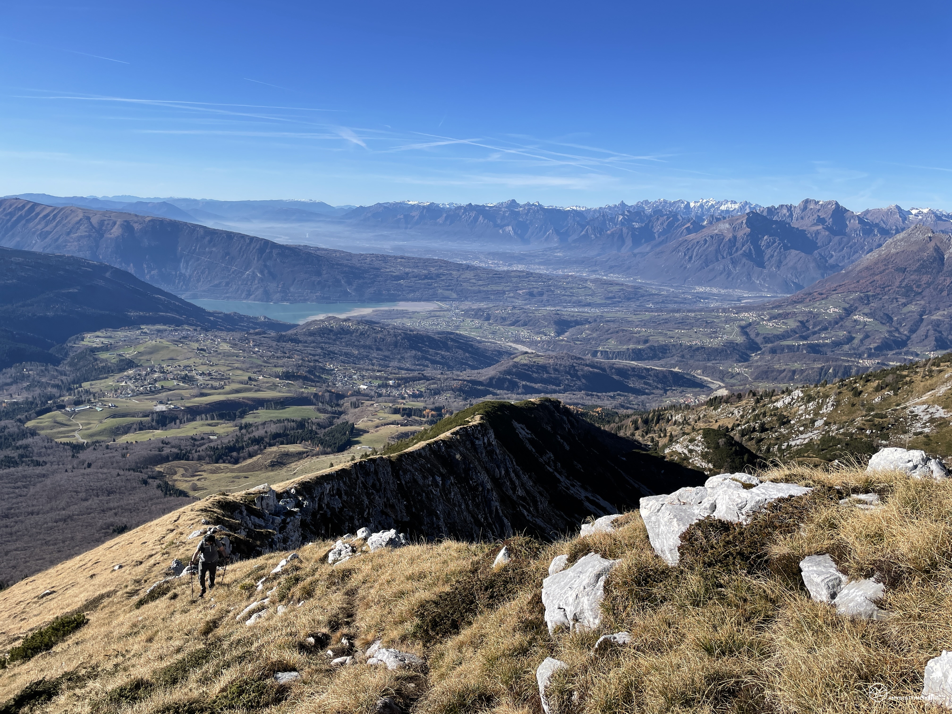
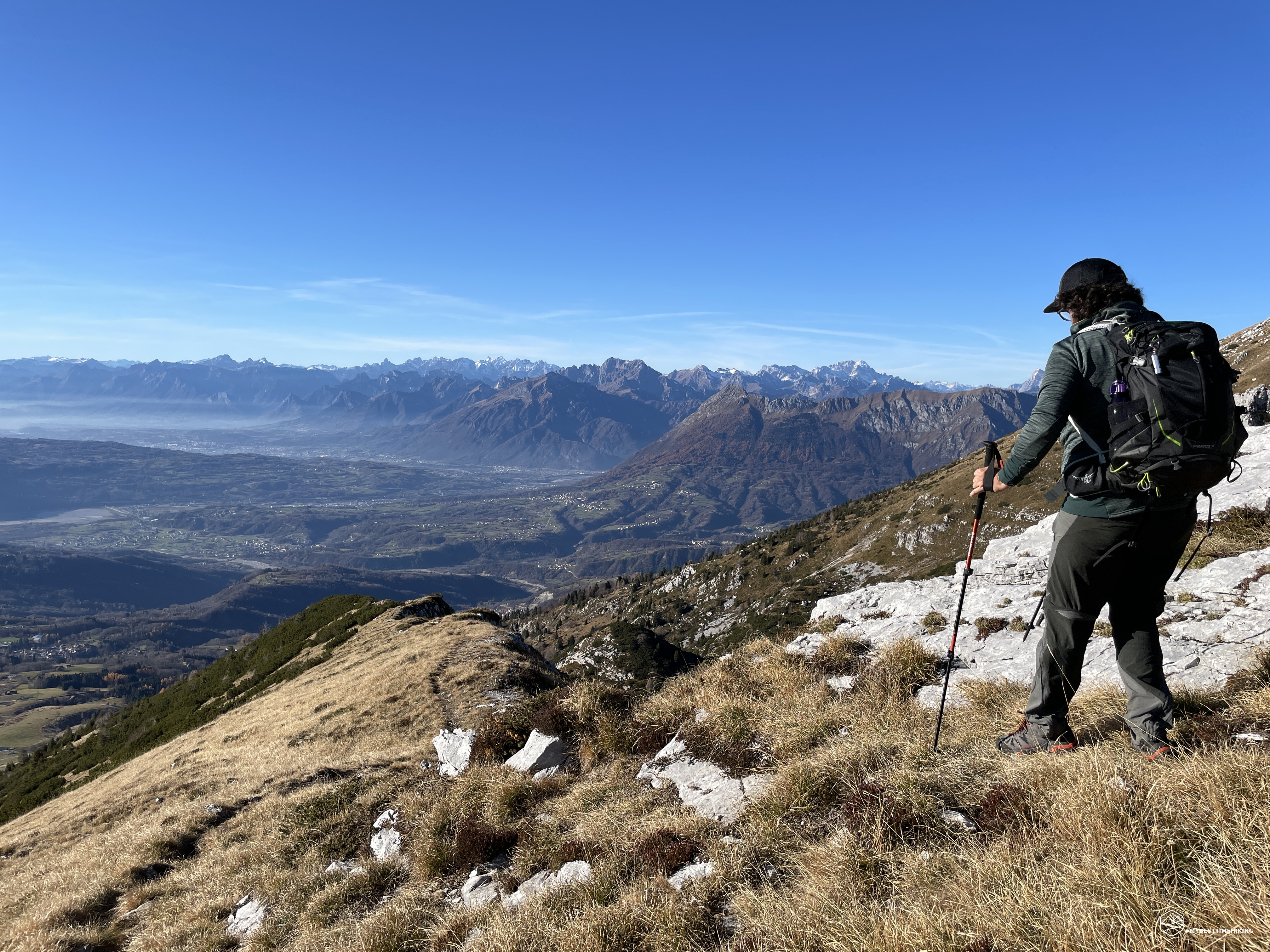
The undergrowth is magical with the sun filtering through the branches of the beech trees and reflecting golden shadows on the yellowed ears. The climb is quite gentle and constant, it allows you to gain altitude with ease. The path at this point is practically a carpet of dry leaves that crunch under our feet with every step. At an altitude of 1500m the forest thins out and gives way to a series of very low and sparse pines surrounded by grassy bands. This opening allows us to enjoy the first view of Lake Santa Croce and the Alpago behind us. In front of us instead we see the Cima delle Vacche and on the left the ridge leading to Guslon.
We continue on the ridge called "Costa Schienon" and, now that we are out of the woods, we feel the sun on our skin in a decisive way. On some occasions it seemed to be on a summer day, in August! The constant presence of a light cool breeze allowed us to advance without sweating excessively.
Date
20-11-2021
Distance
9.12 KM
Hike type
Hike
Ascent
755 mt
- Mountain
Cima delle Vacche
- Address
Tambre d’Alpago, Veneto, Italy
- Altitude
2058.00 m
- Refuges
- Information
As we advance, the coast we are traveling on evolves into a real crest. A blade on which the path continues to travel: on the left a chasm that increases with every meter of difference in height, on the right an expanse of dry grass that is lost in a southerly direction until you reach the woodland. At an altitude of 1800m we find a large clump of very tall mountain pines. In this case, the path has moved to the right, leaves the ridge and internally runs through the needle-like flora. Fortunately, today I don't have to fight with the mountain pines and the crossing is enjoyable even from the shadow they manage to give.
The short interlude of pines gives way to the last few meters of altitude difference made on a razor's edge with a stronger wind whipping from the Cadin Valley to our left. The summit is getting closer and closer, and in the last 100 meters of altitude the grass gives way to an increasingly rocky presence. The official path, marked by red dots on the boulders, is difficult to identify here. The fact remains that everyone can choose the way they like best: the goal is always in sight. Last rocks, last part of unstable stony ground but not at all dangerous, and here: Cima delle Vacche, 2058mt!
On the summit stands an Italian iron flag supported by a steel pole, at the base a large boulder on which you can read the name of the summit and its height above sea level. The view from here is exceptional: on one side the Cansiglio with the splendid recognizable plain, the Lake of Santa Croce, the Alpago, the entire Valbelluna, the Schiara, up to the unmistakable Pelmo! On the other hand, Guslon, Castelat, Mount Cornor that we see covered in snow, Lastè peak, Cimon del Cavallo (Manera peak) and Palantina. Today's splendid day also allows us to scrutinize the plain submerged by a very dense blanket that makes it seem suspended on a sea of clouds. We enjoy the well-deserved ration in the presence of these beauties and we notice runners who run along the rocky ridge that connects the Castelat and the Cornor: a valid alternative for a new wild and sought-after adventure!
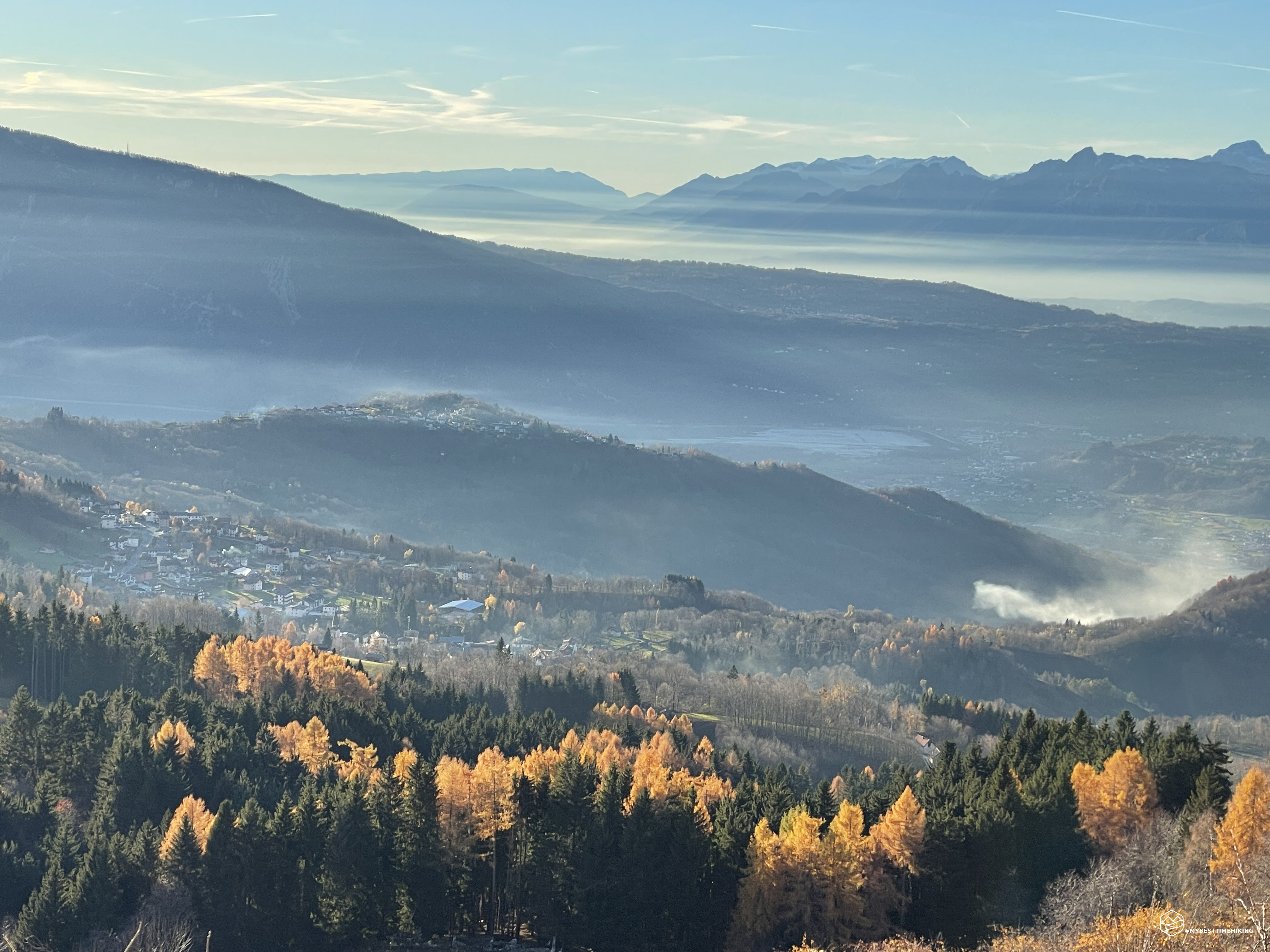
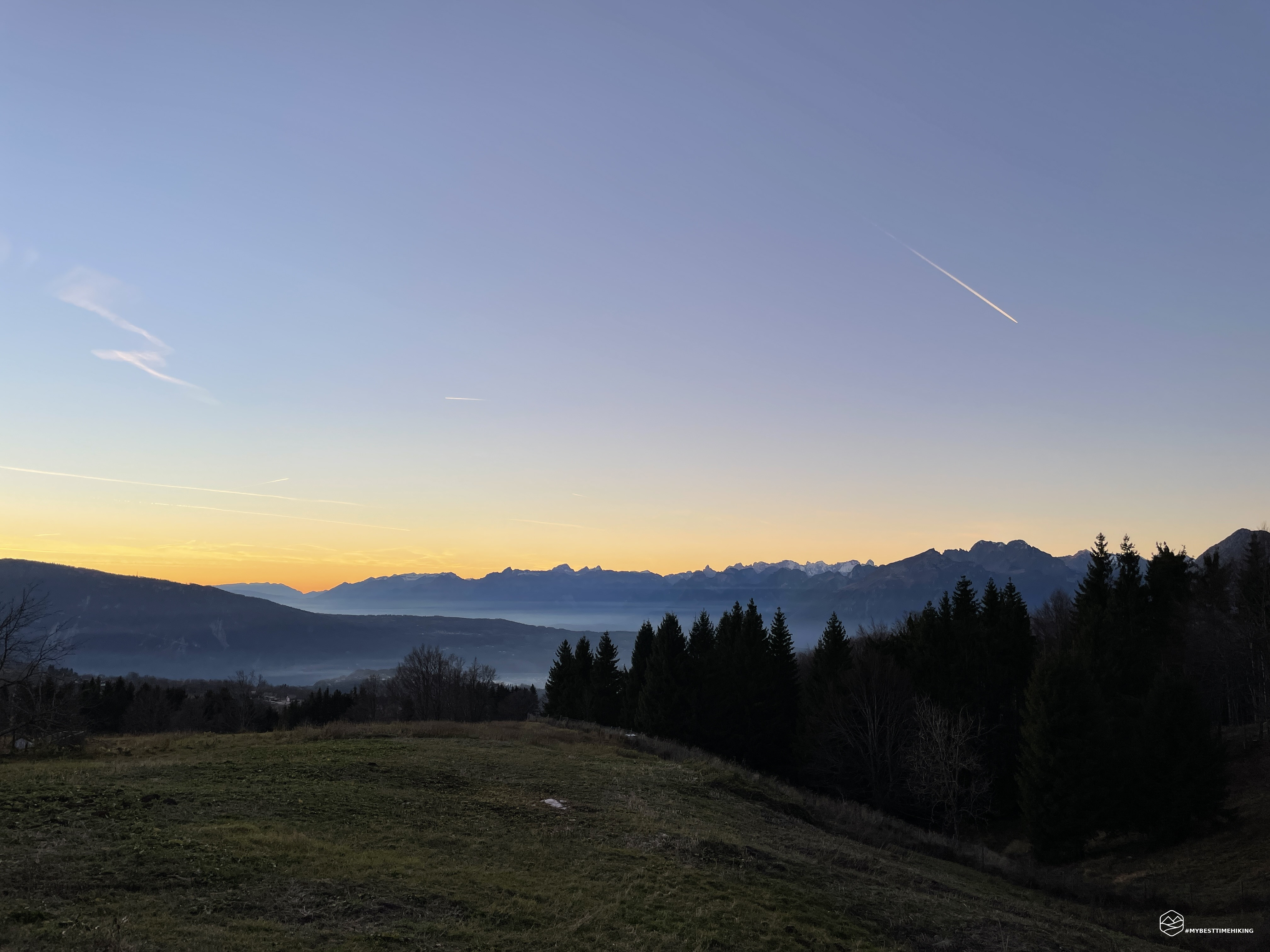
We resume the descent route for the same route as the outward journey. The chasm is now on the right, the ridge is truly original and exciting from this new point of view! Downhill everything is more agile and we quickly reach the pine scrub and then the wood. We already retrace the 800m altitude difference we have just climbed and immediately label the excursion as "exceptional". We return to the Pian delle Lastre hut and, thanks to the season, the sun is already about to set. It therefore gives us a splendid warm light that paints the landscapes and the nearby Dolomites with a special color.
Let's stop at the Pian Grant Malga to enjoy a widely earned fresh beer! Worth mentioning is the variety of homemade products such as salami (spectacular), ricotta, casera cheeses and jams of various flavors. This break, with related purchases, allows us to delay a few minutes and when we go out we are faced with a spatial sunset! We also see the famous enrosadira that brushes the Prealps all around.
An adventure on an almost unknown peak that has given us emotions like the most beautiful Dolomites. The view is exceptional, the route is simple for any trained hiker. A top to absolutely redo. I recommend it in winter, autumn and spring. Thanks to Enrico who shared this summit with me and who I hope to take with me on other new itineraries!
DifficultyHikers - Itineraries on paths or evident traces in various types of terrain (pastures, debris, stony ground ...). They are generally marked with paint or cairns (pyramid-shaped stacked stones that allow you to identify the route even from a distance). They can also take place in snowy but only slightly inclined environments. They require the equipment described in the part dedicated to hiking and sufficient orientation skills, walking training for a few hours. |