

A new exciting adventure: we are in the Fanes-Senes-Braies Natural Park, between Veneto and Trentino Alto Adige. The splendid Fanes Dolomites host us for an epic excursion that I share with the inseparable explorer Diego! Today Edoardo Valleferro, a mountain guide from Cortina d'Ampezzo, is also one of us, radiant to take part in this unprecedented and wild expedition.
The objective of the itinerary is the ring tour of the Furcia dai Fer, the scene of the final battle of the legendary people of Fanes. It is said that right here between the fork dai Fers and the top of the Furcia dai Fers, the Fanes tried in vain to resist with all their might before the final capitulation on the aforementioned peak.
The route taken, however, is not the usual access that from the Pederù refuge allows you to reach the apex of the mountain. Our choice, carefully studied by the meticulous Diego, starts from the Tamersc valley, a few hundred meters from the town of the same name. An old track that goes up a valley facing north, unnamed, never considered by the local guides.
We park the car a few kilometers from San Vigilio di Marebbe, on the road that wedges itself into the splendid Rudo (or Tamersc) valley. Between Tamersc and the Pederù refuge, at an altitude of 1462m, our adventure begins! The morning is crisp, there are a few degrees above zero, the unfortunate exposure to the north forces us to dress a little heavier than usual. Together we patrol the area to be able to identify a semblance of a trace in the bush to take the correct valley. Among the vegetation and with the help of the inevitable GPS, we find a hint of a path between the foliage. We go up in a zigzag first towards the east, and then proceed decisively on the opposite side, always surrounded by the mountain flora that welcomes us.
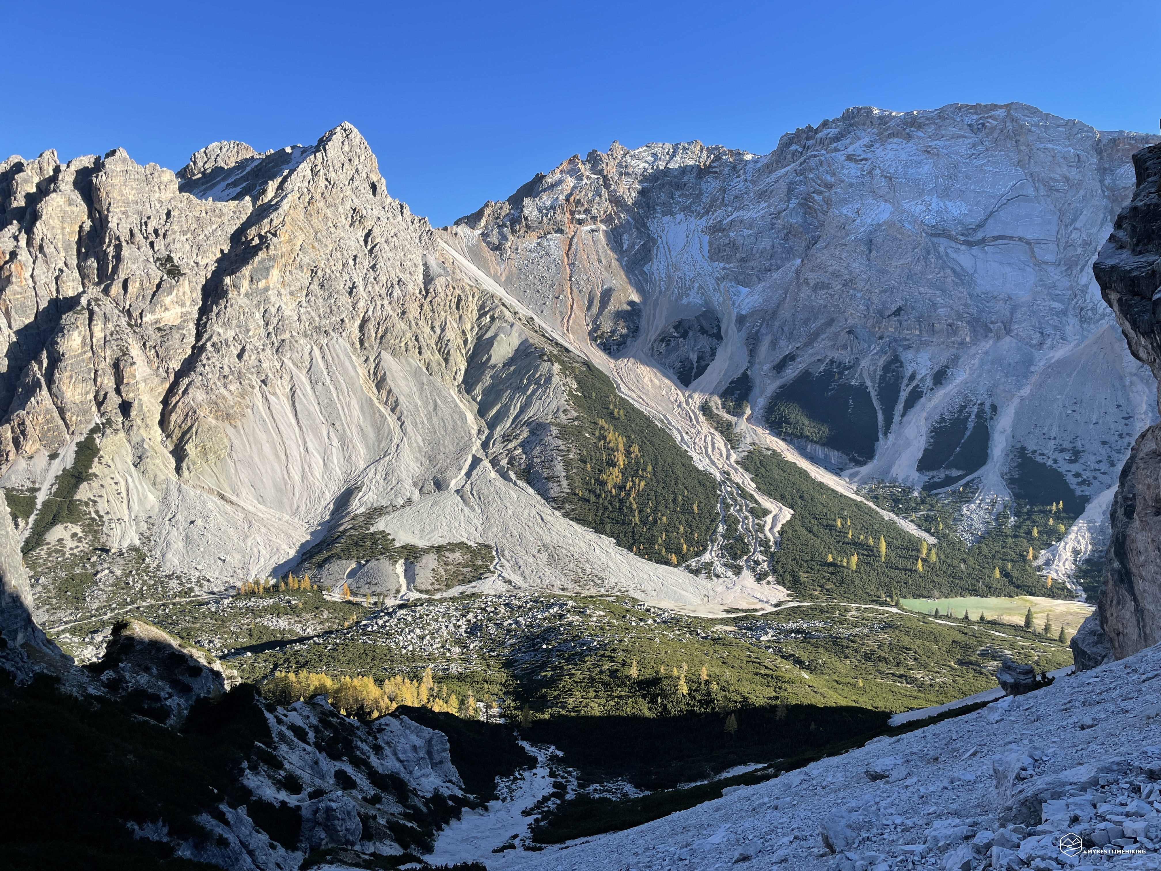
Suddenly the path stops and in front of us a dug and considerably eroded impluvium bottom appears. It is one of the many landslides that characterize this valley. We descend into the impluvium and proceed easily on the boulders. We check the map and we notice that we are moved to the west with respect to the black dashed trace on the Tobacco. We have to go up to the east and leave the impluvium. Here we face the first difficulty: a leap of compact gravel, very steep and hard to scratch even with blows with boots, separates us from the grassy path surrounded by pines. Our guide easily overcomes the vertical portion that separates it and awaits us on the safe grassy front. Diego and I favor a safer progression: Edoardo is confident on the strong pines behind him. With the rope wrapped around the waist we have greater security in moving forward. So first Diego and then I (with an improvised pendulum) go up the gravelly leap.
Now the track definitely changes appearance, the grass becomes the constant for a long time. The frost does not help the easy progress and we must properly check the support to avoid slipping. The path is always poised on a little exposed but deep window. Fortunately, the young mountain pines make it easy to take out insurance. We arrive at a rocky wall where we notice faded marks that allow us to precisely identify the old trace. We then continue along the rocky ledge, bypassing it on the right. The climb becomes gentler, in some places almost at high altitude. There are no more crags or overhangs, we proceed calmly towards the south in the woods among crashed trees. We thus reach a crossroads where we notice a little man and a series of trees that almost indicate a "door" of access to the "mother" landslide that distinguishes the unnamed valley.
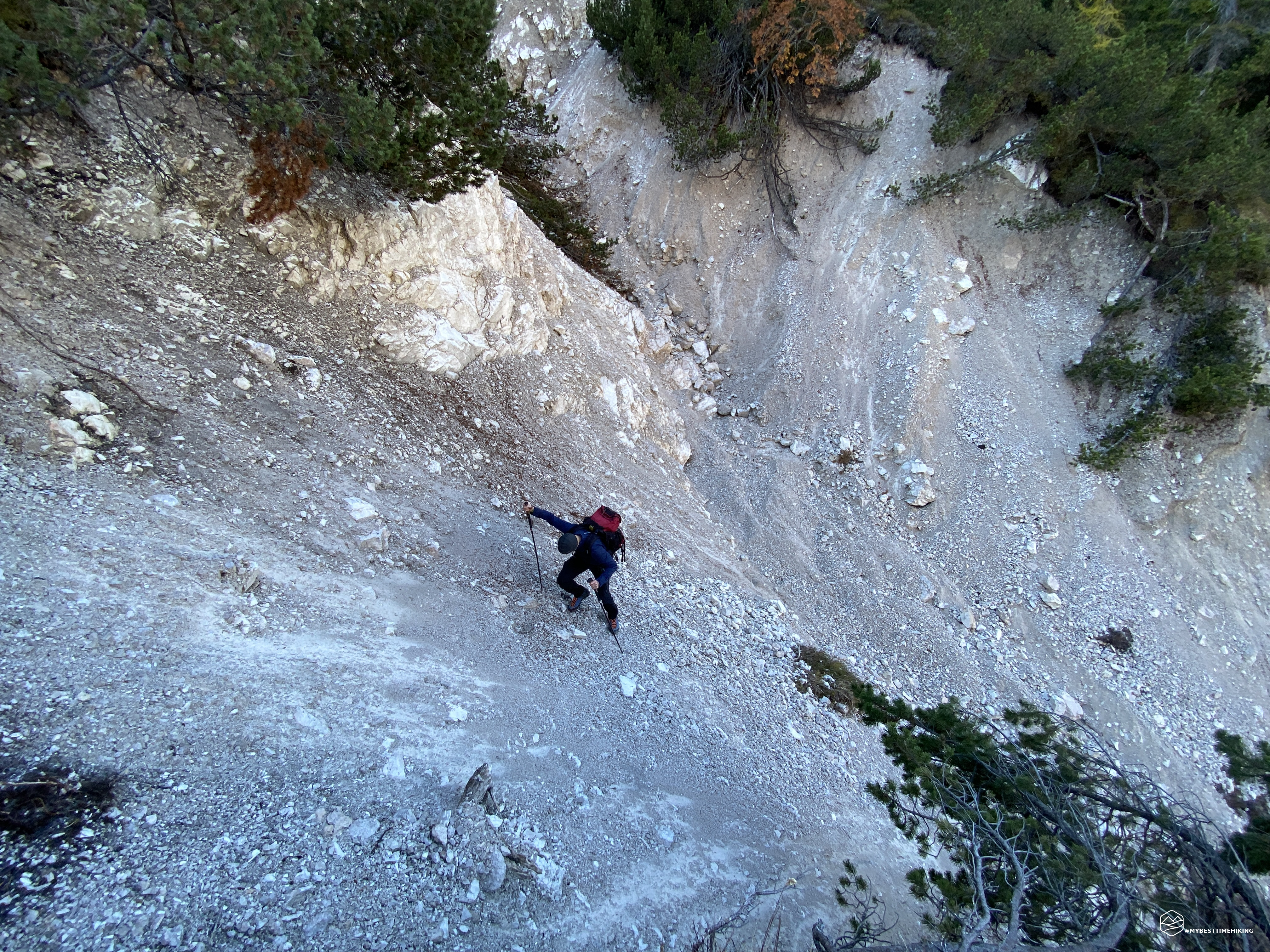
Here then is the majestic dry pebble that cuts through the valley. Continuous landslides have shaped it by destroying the way of the historical path that we are trying to retrace. The sun begins to peek out from behind the Furcia dai Fers. We notice the ice sheets that occasionally cover some rocks with a very thin layer. We do not lose concentration and proceed keeping first to the right in the direction of a scrub of larch which is turning a golden yellow with the first warm rays of the sun. After a crack in the impluvium, we decide to skirt an imposing rocky watershed block and go around it on the left. Here the gully becomes narrower, with smooth rocks on the left, a small rivulet of frozen water in the center. On the right, on the other hand, a gravelly crag leads up to some comfortable baranci which thus skirt the gully from above. Diego, wisely, immediately goes up to the right and ensures a very comfortable route for the progression. Edoardo and I, on the other hand, continue among the rocks on the left. After a few hundred meters the guide deviates to reach the right side. The difficulties he encounters are overcome with extreme ease which denote absolute admiration for him. I arrive in a "cul-de-sac": I am surrounded by rocks as high as me, under my feet the frozen stream and in front of a small waterfall also frozen. I can't easily find a way to overcome that obstacle without risking slipping and falling backwards for several meters. Edoardo comes to my aid by securing the rope to a mountain root. Now, insecure, I carry out the steps I had planned to do: without problems I can go up even without the help of the rope. Being insured allowed me to overcome the difficulty more lightly. I can say I made my first frozen waterfall!
Date
17-10-2021
Distance
11.08 KM
Hike type
Hike
Ascent
1020 mt
- Mountain
Furcia dai Fers
- Address
San Vigilio di Marebbe, Trentino Alto Adige, Italy
- Altitude
2534.00 m
- Refuges
Rifugio Pederù
- Information
The difficulties are not over: in front of us there is an access on friable rocks with behind a nice jump of rock that ends in the gravelly gully. We proceed with caution, until we reach a patch of inseparable mountain pines. We must go into this tangle of baranci to emerge on a new impluvium (the last one), before going up again on an easy grassy ground. Here the cartographic Tabacco marks a crossroads: the left track stops shortly after, while the right track climbs up sloping rocks at the foot of Piz de Sant'Antone (or Muntejela de Fanes). We choose to take the easy way out. We definitely make the best choice because we go up a steep scree, very easy, and we come out on a splendid, open and sweet valley. We do not understand how the old path could have chosen such an inaccessible route when on the other side the track is so beautiful and simple.
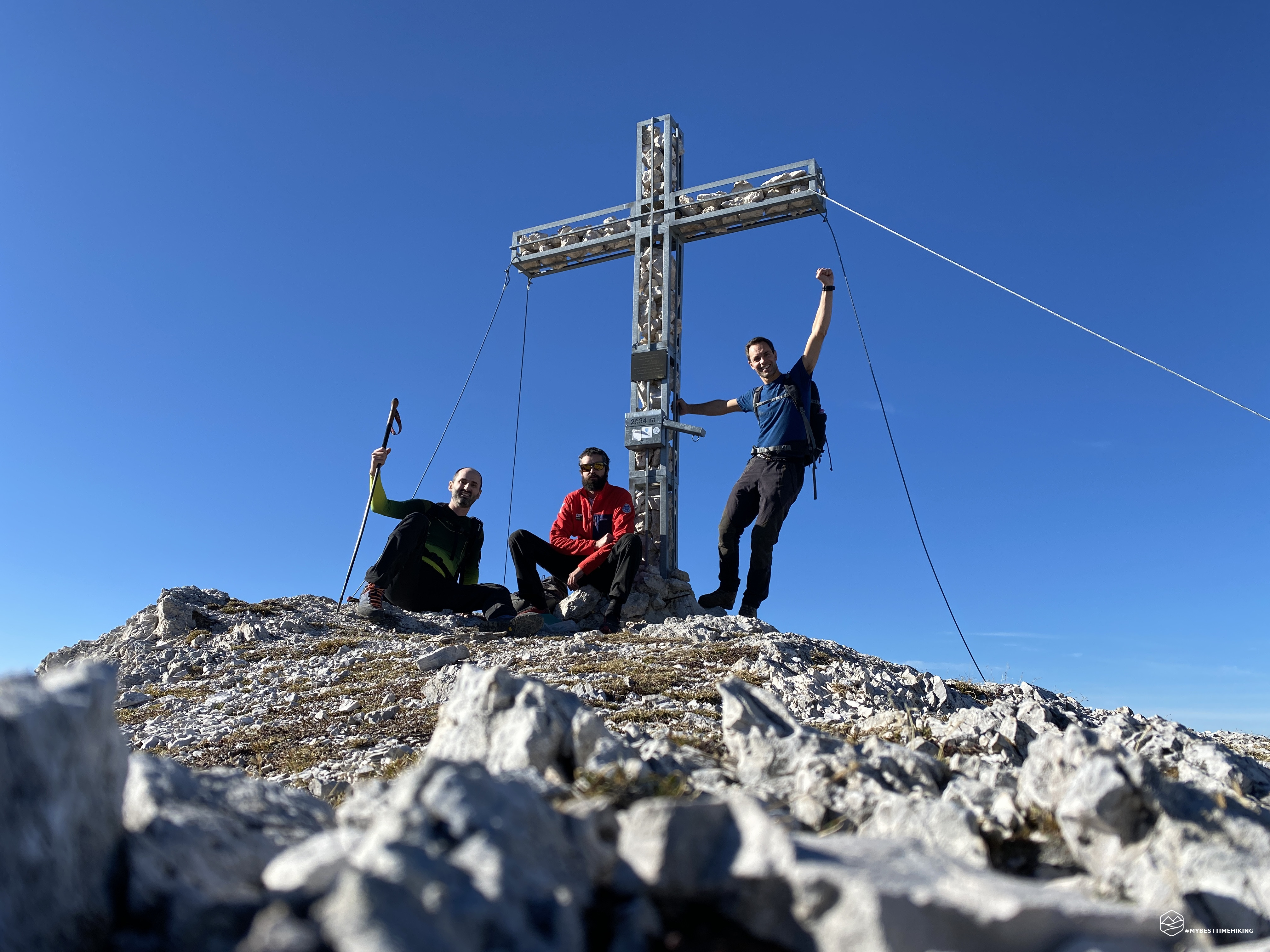
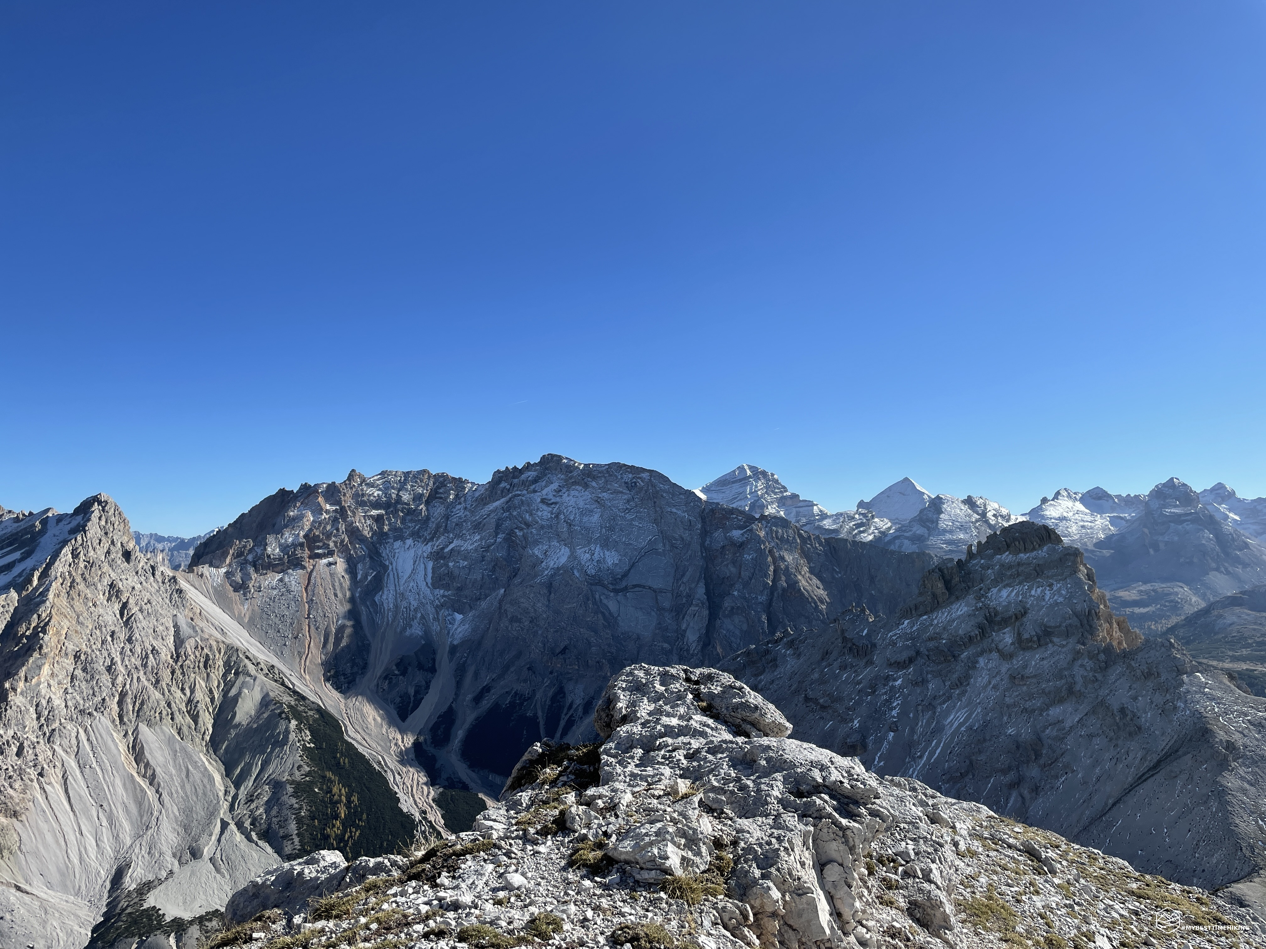
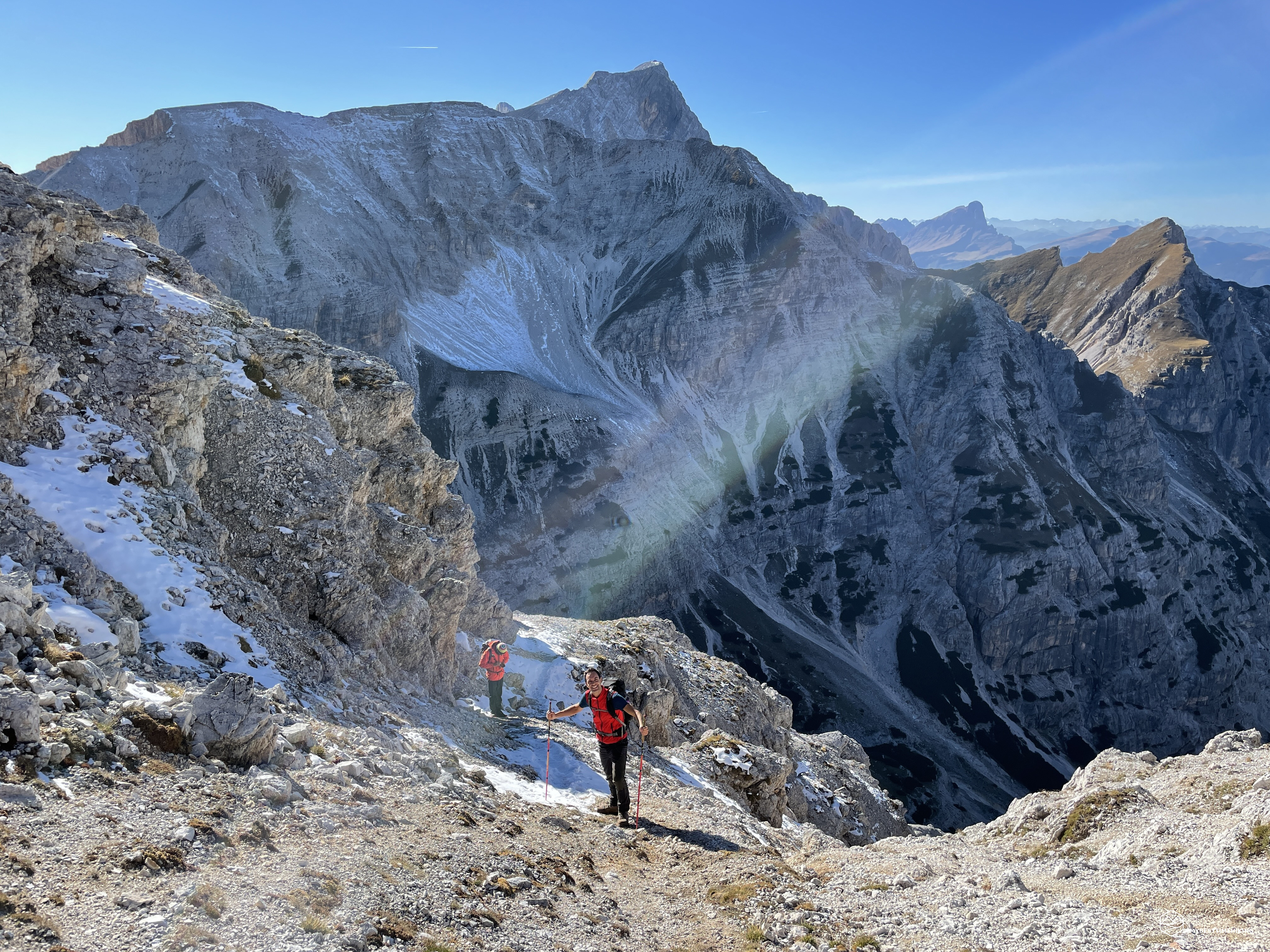
The view is already breathtaking, on this splendid silent valley we see an immense group of chamois at the foot of the Furcia dai Fers. They will surely have seen us and, in a hurry, they are using makeshift ledges to protect themselves from our prying eyes. I had never seen such a large group of chamois, a sight! We keep to the left and try to gain altitude on the slope that points straight to the top of the Furcia dai Fers. A ridge with grassy steps interspersed with fine gravel. The steps allow an easy ascent, the slope becomes decisive and in about an hour we gain more height difference than what we have done so far. We thus reach the ridge, which is exclusively gravelly. Here the panorama becomes more and more aerial and we have an optimal view of the magnificent Croda Rossa d'Ampezzo, we distinguish precisely the Camin fork and the Gran Valun explored a few weeks ago. Behind the Col Bechei Dessora you can see the already snow-covered Tofane and the unmistakable Tofana di Rozes. The crest climbs to the left, so we go around the top of the Furcia. In the shade we find patches of snow from a recent snowfall. Last steps, last easy rocks to overcome, and here we are: we are at the top of the Furcia dai Fers!
The day is beautiful, not even a cloud in the sky. The sun warms up like on a mid-June day, we are at an altitude of 2534m! The imposing summit cross makes it possible to identify with dignity this splendid peak, the solitary lookout point of the Fanes Dolomites. Our gaze crosses Piz de Lavarela, Sass dla Crusc, Sasso delle Nove, the peaks of the Aurina valley and the most distant Austrian peaks. In front of us the legendary Croda Rossa in all its splendor with the magnificent Colfiedo fork. Diego notes our passage on the summit book by recording the unprecedented access route from the Tamersc side. After a short break to savor these wonders, we take the path of descent.
We retrace the crest backwards, staying firm on the left in the direction of the clearly visible saddle. Once reached we have an optimal view of the valley below. The direction to take is east where there are no signs or traces marked. Also on the Tobacco map there is only one ski mountaineering route. However, throughout the path there are clear stone men that perfectly identify the trail to follow. However, there is no danger of getting lost and, in the event of a wrong choice, it is easy to retrace your steps without difficulty. After a first part of grassy ground, we go down on a soft and fun scree (finally). We always skirt a patch of mountain pines. At an altitude of 1900m, the gully ends suddenly and a new feast of baranci (sigh) appears in front of us. Actually from the GPS track we have to deviate decidedly to the left (north-east) and immerse ourselves in the dense scrub. After a few hundred meters we find a timid track that leads us to a very pretty remote hut. Here the path stops again, we find it a little further on facing the last row of pines right in front of the entrance door of the hut. We thus reach the CAI path n ° 7 which leads to Pederù.
Our car, however, is in Tamersc and from the Tobacco map we see a track (always historical) that from there should skirt and go around the rocky ridge, stay at high altitude, and then arrive directly in the Tamersc valley. We try to find this route, but the presence of dense mountain pines, continuous steep gravelly slopes created by landslides in continuous movement, force us to fall back towards trail no.7. We continue to look in the direction of the track that should be there a few steps from us: the rocky walls and the various landslide gullies that we notice make us think that this path is now a distant memory and there is no viable path. The adventure comes to an end once you arrive at the Pederù refuge and the contiguous asphalted road that soon brings us back to the parking lot of the outward journey. The warm sun of the sunset tinges the peaks of Fanes with a soft yellow-pink, gives unprecedented shadows and accompanies us at the end of this magical excursion.
A new exploratory stage has ended, even our guide, Edoardo, was pleasantly satisfied with the unprecedented route. Retracing these remote places, without the mass tourism that develops a few kilometers from the paths we have traveled today, in silence and solitude, awakens something unusual and profound.
Now, a few days later I retrace the emotions, and I notice that I cannot fully describe them. I am here that I enjoy a nice glass of mountain pine grappa for two reasons: first to toast the feast of baranci and the help they have given me on several occasions along the route and, second, in honor of the legendary people of Fanes who fell on the majestic Furcia dai Fers!
For an even more complete and detailed view, I invite you to also read Diego's report on his blog WINDCHILI - AROUND THE WORLD .
DifficultyExpert Hikers with Equipment - The equipped routes (or via ferrata) are indicated, they require the use of self-insurance devices. |